


EPSG = 27700?
Sorry, yes converting it that way would be British National Grid 27700
1 Like
I feel for you. Coming from the land surveying side myself most recently with Topcon gear I had to learn how this different sect was used to doing things and how drastic of a change there is with going back to an L1-only device. Around 20 years ago when GNSS first became publicly available to us we only had L1, but in comparison to a total station for large topographic surveys it was still a huge benefit. Though we did learn that it has its time and place and how to integrate the data. Now that we have L1/L2 and almost L5 the L1 only devices can be frustrating. There again they have their new place in the world. I have a pair of RS+ and a pair of RS2’s and there is a drastic difference. I would definitely put the RS2’s on the level of Trimble/Topcon/Leica, but our RS+ units have been relegated to small site surveys less than 100 acres and/or PPK for drones and GCP’s.
I know the expense is a big thing, but I will say that even with the RS+ devices software was a drastic change. When we only had Reachview 2 and I could not get it to do what I wanted it to I purchased MicroSurvey Fieldgenius and it closed the gap quite a bit. I still had some issue with a strong RTK fix, but I could then use localizations, local coordinate systems and GEOIDS if I wanted. That’s the difference between GIS and Land Survey. Now that we are getting Reachview 3 tuned up it will be able to do everything except localizations which I can work around easily now.
You might think about emailing Emlid support to see if you can get on the RV3 iOS beta?
2 Likes
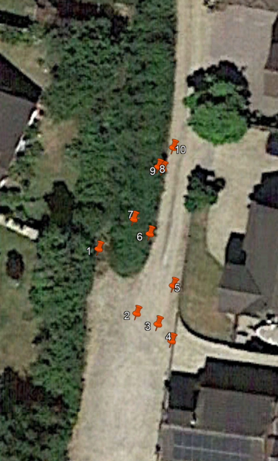
Yes that’s almost it! I had the same results when imported the onto a map but my garden is actually that bit to the left.
Points 1, 7, 9, 8 and 10 are the edge of the yard/paving and 2, 3, and 4 are edge of garden where there’s sleepers with 5 & 6 just being a couple of levels.
Once again i do really appreciate you taking the time to help with this and sounds like we’ve had similar surveying progress/backrounds.
I’ve looked into the Field Genius app the other day but i think it’s just from MicroSurvey themselves rather than available as an actually app from the Google play isn’t it? How did you get that for?
-“but our RS+ units have been relegated to small site surveys less than 100 acres and/or PPK for drones and GCP’s.”… ha ha that’s exactly what i want them for now!
No worries, I am learning new things on the fly as well.
With FG you still setup the base and rover in Reachview and the receiver are just a piece of hardware/equipment in FG. Pretty much the same we are doing now until RV3 is fleshed out. Setup in a browser in RV2 and survey in RV3.
https://www.microsurvey.com/products/fieldgenius-for-android/
I don’t know if you’ve ever used a localization before, but that is the solution to making the control match the field conditions for what is really there versus the CAD and can also put your site in relation to a totally arbitrary grid like 5000,5000. I will shoot you a CSV and DXF later today once I have figured out the transformation from WGS84 to OSGB36. My QGIS is acting strange.
1 Like
Ah brilliant thank you.
Where are you based?
With regards to RS2’s are they a game changer?
I am in The United States, Texas. I believe the RS2’s as far as hardware goes are every bit as good as the Topcon receivers and would be just as functional when RV3 gets to final form. Otherwise with FieldGenius for Android they are already as good if not better because data collection on the Android app is so much better than Windows CE. On par with a Windows 10 installation if not better because I think the big 3 are still adapting to full Windows.
1 Like
Already when we transform from WGS84 to OSGB36, The accuracy can range from less than a meter to 20 m.
So you have to be careful when you convert.
1 Like
There were 3 different versions that I can transform with, all being Inverse as it doesn’t seem to be using the default. There were many options of accuracy for different use cases.
1 Like
@michaeldroberts1975, I just got out my RS+ receivers to get them updated and had connection issues with my base. I could see it on my WiFi network and RV3 told me to update, but it would never pull up RV2 in the browser. I held down the power button for about 15 seconds until all three LED’s started blinking together and when it rebooted it went into hotspot mode, I told it to forget my WiFi and it worked out.
2, 15 and 21 metre accuracy?
Yes i can see the danger with conversions.
There must be a successful workflow though or it would make the units redundant for any type of accuracy?
I am not very familiar with transformations in your coordinate system, but this is what it gives me in QGIS.

…and actually there are even more options. I think the preferred was the 1m that failed.
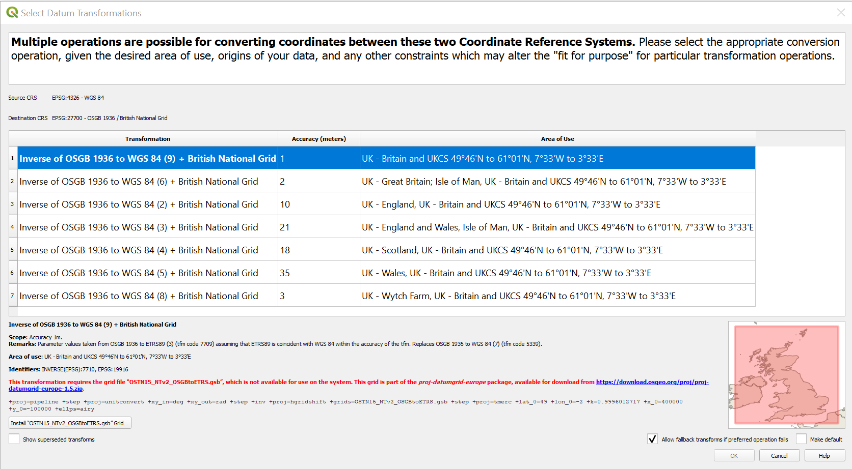
*addition, it does state different purposes for each transformation such
as the preferred 1m, 2m for oil and pipeline, 10m for military…
In our region this has always been something that we have to verify per the construction plans or a chat with the original surveyor. Once you figure out what conversion then just stick with it on that project. You’ll find one that is most common, but we always have to verify before establishing our control.
Thank you for trying that.
What would be your advice for getting the info from Reach View into a format that i can simply edit in autocad to produce a topo with no OS or coordinate orientation needed… so basically a dot to dot where all the points get imported and i create polylines to produce an old school topo plan.
My main goal at present is to just get an accurate set of data that’s just accurate to within itself if that makes sense and not require any conversion to a coordinate system.
What about if i change the settings for data collection to xyz rather than LLH?
I haven’t got any jobs at present for the gps so i just want to get the system working as a simple data collection unit and then further down the line when i’ve got an understanding and workflow sorted i can then start looking into NTRIP etc.
I think QGIS is the way to go until RV3 comes out (or even when it does if you get comfortable) and you can use you local meter-based coordinates. QGIS is free, you can load the native WGS84 points and drone data, draw linework, draw contours and make surfaces from points or TIN files and allot more that you may never need.
Once RV3 can get your points out in meters then the alternative is to get a Cogo style CAD program. I Googled “survey CAD” and a few popped up that are much less expensive. I have not used these, but the verbiage seems promising. I do not see a trial for this one. $299 for cogo and $399 with DTM’ing for creating surfaces and volumetrics.
Pricing | PC Survey (this seems a little too simple)
1 Like
This topic was automatically closed 100 days after the last reply. New replies are no longer allowed.
Hi there,
It’s been two years since the last message about AutoCAD format was published by Michael. Since then, we’ve added DXF data import and export in our free mobile app ReachView 3.
You can give it a try and feel free to ask anything in the new topic! ![]()
UPD: fixed wording
2 Likes