I’ve been doing some testing with my Reach units and I thought I would share my findings for the benefit of other users.
I’m an electricity surveyor and I’ve been using survey grade GPS for the last 10 years, so I have lots of experience using all types of survey kit.
I purchased my Reach units to use as part of my drone mapping business as I was looking for a system that was light enough to use on a small drone to enable precise geotagging of images.
I must say I was a bit sceptical about the accuracy of the reach system but I must say the results I’m getting are fantastic considering the low cost of the kit.
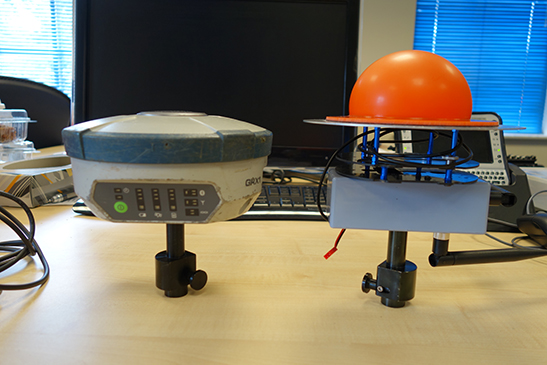
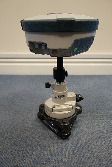
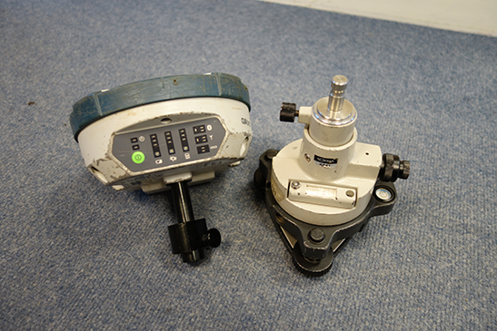
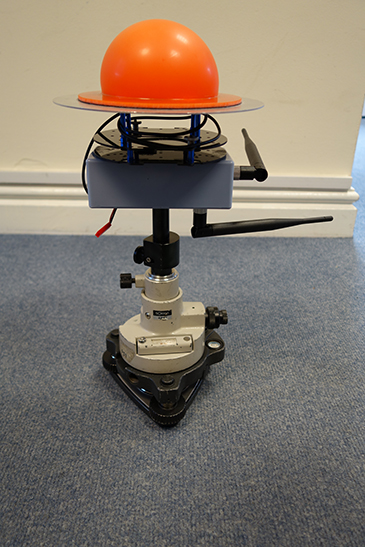
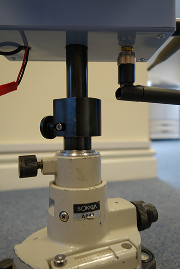
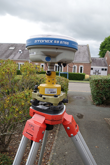
I fabricated a box to hold the Reach that fits on to a standard Leica tribrach adapter. This allows me to swap out the reach for my survey grade Stonex S9 or Sokkia GRX1 GNSS units.
I set up two tripods and placed the Reach on one and the Stonex on the other. I observed raw data for half an hour then swapped the units over and observed another half hour of data.
Once I had logged raw data I connected the Stonex to TopNet, a network correction service that I subscribe to from Topcon. I averaged 50 observations to get a precise coordinate to compare against the Reach unit.
After downloading the raw data from the Reach I post processed the data using Ordnance Survey RINEX data from a single base station 38km away from my location. This gave me a Q1 solution. I then calculated the median of the Q1 position log to get a single coordinate for each setup.
Results
Reach Setup1 - Lat - 53.04880608 Long - -3.013051639 Elev - 148.7011
Reach Setup2 – Lat - 53.04868874 Long - -3.012711844 Elev - 148.4017
RTK Setup1 - Lat - 53.025529929474 Long - -3.004577134315 Elev - 148.339736
RTK Setup2 - Lat - 53.025570188320 Long - -3.004698505612 Elev - 148.810647
My next test will be to see if the Reach can use my TopNet subscription to get a real time precise location to set the base up in the field to give an accurate real world coordinate.
All in all I’m very happy with the reach system and I can’t fault it as a relatively simple way of getting precise coordinates for a very reasonable cost.
I would like to say well done to the Reach team for producing such a nice bit of kit.
I need to do a bit more testing to work out the phase centre of the antenna before I can use the reach for measuring height.
As my reach mount is home made I plan to take several sets of observations to work out the phase centre by comparing each set of results.
I also plan to run a level loop with my total station using the same tripods as the Reach mount I made is compatible with standard survey tribrach’s and prism carriers.
Did plan to do it this afternoon but its pouring with rain at the moment, here’s hoping it clears up a bit later.
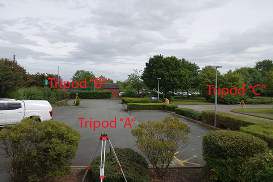
Well the rain has finally stopped so I managed to get out this afternoon to do some more testing with the Reach.
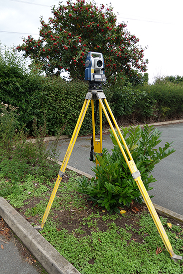
The test comprised of three survey tripods set up to form a triangle. I set-up the Reach on the first tripod, a Stonex S9 on the second and a Sokkia GRX1 on the third tripod.
I observed 20 minutes of data on each tripod then moved the units in rotation to get observations for each bit of kit on each tripod. With the Sokka & Stonex I also logged the points using TopNET to get a RTK fix.
I tried to use TopNET with the Reach and although the correction link worked and I was getting data, it didn’t get a fix. It just stayed on float for the whole time. I think this is probably because I am some distance from the nearest base some 38 km away.
After I got all the GPS data I recorded the location of the tripods with my Sokkia CX total station.
For the 1st station point and backsight I used the RTK points generated from TopNET hence the 7mm horizontal error and 33mm vertical error.
The results of my traverse are as follows.
Point A - B
Distance
Elevation
Calculated
25.830
95.598
Measured
25.837
95.565
Delta
0.007
-0.033
Point A - C
Distance
Elevation
Calculated
27.910
95.895
Measured
27.910
95.893
Delta
0.000
-0.002
Point C - B
Distance
Elevation
Calculated
22.220
95.484
Measured
22.220
95.482
Delta
0.000
-0.002
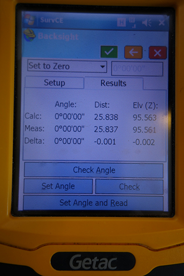
Point B - A
Distance
Elevation
Calculated
25.838
95.563
Measured
25.837
95.561
Delta
-0.001
-0.002
The next step is to process all the GPS data to be able to compare each set of observations to see what the differences are between each GNSS Receiver.
That poor old Sokkia has seen better days!!
Good to see some objective testing being done- Looking to get a pair of Reach Rs units soon so am keen to put them up against my various survey GNSS receivers and see how they compare.
Thanks for this test Peter. This is most valuable and objective information.
We all need to know the limit of this equipment as most of us are doing pro jobs.
Bought the GRX1 new four years ago and yes its been well used over the years but still works flawlessly, a testament to how well Sokkia & Topcon engineer their kit.
I do wonder sometimes if my surveyors use it for knocking the pegs in!
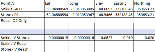
So after post processing each set of data here are my results.
Point A - Q2 Solution
I was unable to get a Q1 solution on the Reach - Maybe due to the distance from the base or the occupation time (20 min) I would appreciated some advice on my settings to see if there is anyway to improve the solution. (See settings below)
Both Sokkia and Stonex got a Q1 solution on this point.
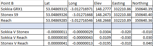
Point B - Q1 Solution
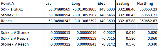
All three receivers achieved a Q1 solution on this point. The Sokkia and Stonex were within 20mm of each other. What’s more impressive is the Reach was within 40mm.
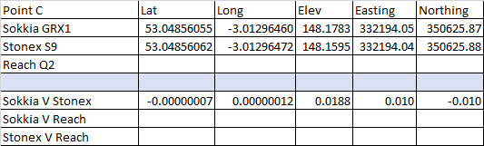
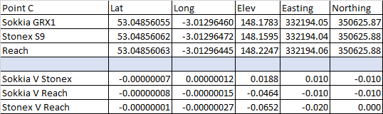
Point C - Q2 Solution
Unable to get a Q1 solution on this point with the Reach.
Both Sokkia and Stonex got a Q1 solution on this point.
Observations
Both the Sokkia & Stonex are L1,L2 & L5 receivers.
My first go at processing the data, I used L1 only on all receivers and the time to fix was quite long. L2 gave a modest improvement but when I switched on L5 the fix was instantaneous.
I would think a half hour occupation would allow for a Q1 solution but that would mean a fair amount of time spent on site collecting GCP. My next test will be to see if this can be sped up by fixing the Reach base using OS RINEX data. Then once a Reach base has been established I would use a second reach as a rover with RTK to speed up GCP collection.
Or I could always just use RTK on the drone and dispense with the GCP (Would still need check points)
All in all I’m still very impressed with the Emlid Reach. Even during the short time I’ve owned two, the system has been is a state of constant evolution, with regular updates that keep adding functionality.
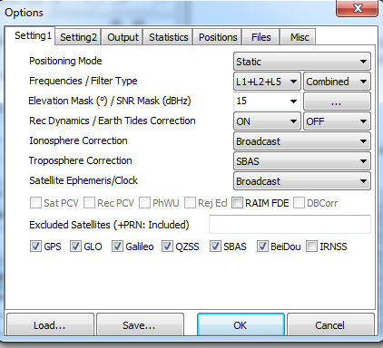
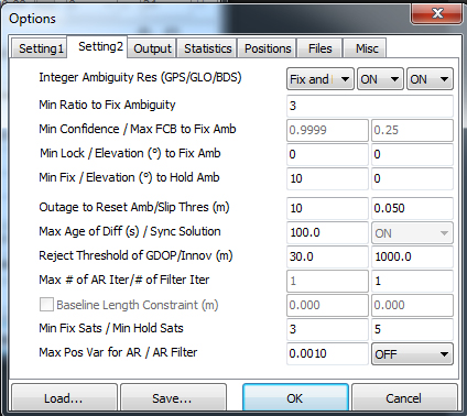
Use only L1, use continuous, turn off Glonass AR and BDS AR.
I also under my hemisphere get better resolution with only GPS and SBAS and/or in combination of another system.
I rarely gain better performance with all systems enabled
You use a base station 38 km away ? That is a bit optimistic for L1 only system. My bustiness typical case will be to keep Reach RS base inside 10 km from GCPs. Should I need longer baseline to catch a geodetic monument, no other choice in my opinion to borrow a pair of L1/L2.
As you say, for multiple GCP we have to keep reasonable survey log time. From what I see up to now, when RTK is not feasible, I plan 10 min log per point. But only if base is close enough to rover.
I’ve re-run my data with your recommendation and I now have Q1 solutions for all three points.
Point A
This one struggled to get a Q1 fix and as you can see its not as good as the other points. This may be anecdotal but this point was closest to my office and within range of three wifi networks.
Point C
Only 20mm difference between the receivers Very Impressive
I’m just putting the Reach through it’s paces in this test. Thanks to TB_RTK a Q1 fix is not beyond the realms of possibility even at 38 km.
My office is located smack in the middle of three OS bases so I’m about as far away from a base as you could get in the UK.
In my everyday job I use my Stonex S9 for surveying power lines. This uses TopNET RTK so I get a real time fix most of the time I’m out on site. The only exception to this is when I can’t get a mobile phone signal, then I have to break out the base.
My reasons for looking in to the Reach system is I get a lot of enquires from fellow UAV operators asking about affordable GCP. Hence my interest in the Reach.