Hello emlid community,
After marking GCPs on field we are using Stop & Go method for post processing. I am getting variation in height for same GCP point, when i took the reading of same GCP point after two days its value is changing from 50.667m to -17.442m. I am attaching Screen shot of corrected point using STOP & GO method taken on 19/03/2023 (Corrected_New) & 17/03/2023(Corrected_Old) which show the variation
In similar manner, today also we have face same issue.
We had took three readings for the day(GCP1_21/03/2023) and compared that result which was taken six day earlier(GCP1_14/03/2023).I am attaching result of Screen shot for both the days.
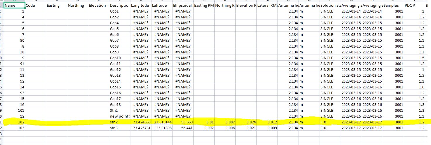
That’s bizarre. if you look closely at the latitude and longitude, you’ll see that they are slightly different for stn2. Is there a chance that your base position got adjusted accidentally? If you share the data, I would be happy to take a look. I would need the raw data and em flow csv.
I agree with @Zaz5400 – it’s hard to say what happened right away, but the data should help find the root. Can you please share the logs, CSV files, and the base coordinates you used in Stop & Go for a closer look? If you’d like to share the data privately, you can send it to support@emlid.com.
Also, just in case, did you enter the base LLH coordinates in WGS84 in all the tests?
Sorry For the late reply, I am busy in multiple testing on the field regarding instruments (If anything is wrong with Base & Rover).
1.We are getting centimeter level accuracy(6 to 7 cm) in current data in the stop & Go method from the last few days. Earlier when we are processing with base and rover file at that time we are directly use default option of (Rinex Header Position) but now we are selecting (Lat/Long/Height) option from the drop down menu of base setting and add manual base settings that we got from manual averaging. I would be happy if I got more thoughts on this topic as I want to reduce this error below 2cm (During Base shift on known point i am facing this issue as well)
but now we are selecting (Lat/Long/Height) option from the drop down menu of base setting and add manual base settings that we got from manual averaging
Thanks for sharing what worked for you! We indeed recommend entering the base coordinates manually in Emlid Studio for most applications. It helps you tie the results to a specific coordinate system and achieve absolute accuracy.
I would be happy if I got more thoughts on this topic as I want to reduce this error below 2cm
Centimeter-level accuracy is a standard for RTK and PPK techniques. The exact accuracy depends on different factors, such as baseline, satellite geometry, and so on. Still, you can try the following to improve it further:
Decrease the baseline. You can do it by placing a local base close to the rover.
Ensure that your results and the known points for comparison are in the same datum. Otherwise, you can see a shift from centimeters to meters.
Level the unit as precisely as possible and average points for a longer period.