hello, i bought a phantom 4 pro v2 and I want to convert it to a mapping drone that can do ppk. I’ve read the topics in the forum, and there are some things that I wonder about.
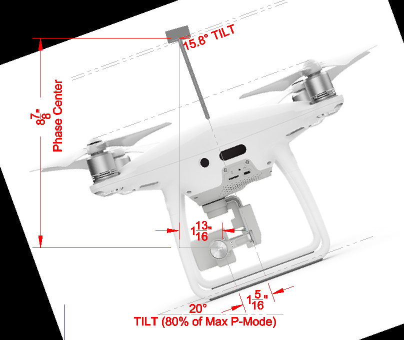
1-) While we are collecting some data from site with on motion drone, it will be an antenna tilt deviation error in collected data. How could we fix it? (tuffwing or teokit)
Are you setting up ground control in addition to the camera sensor GPS locations, or are you just trying to get better aerotriangulation with the Reach unit without verification of accuracy? PPK processing of GPS locations from an external unit on a Phantom 4 is an involved and potentially messy process and will only utilize 1 questionable GCP (takeoff location). Using adequate GCPs with the photo Exif information is a pretty solid solution for registering your drone mapping products.
As far as the tilt offset, the information is there in the Exif data to calculate the deviation, but the Tuffwing literature does not mention if this is considered (thought probably does). Teokit does mention this. You should be able to continue hobby flying and the Reach unit will just record locations when you take a photo with either solution and you don’t need to deactivate anything (DJI GO 4). The units do not control the camera, just record information through the infrared sensor (Tuffwing) or CAN bus (Teokit). As far as programs, you can use DJI Ground Station Pro for flight planning and mission execution, and Pix4D (these vendors mention) for map products creation (or OpenDroneMap if you are on a budget). Both units appear to do the same thing - record camera timing and other sensor information (Teokit) which you then match up to photos as a post processing procedure. They don’t require special programs - Reachview, RTKLIB, and Excel for processing Tuffwing data. Teokit uses it’s own TeoBox software. Special programs are required to produce the map projects, and with the exception of OpenDroneMap (high learning curve), they are not cheap (AgiSoft Metashape, Pix4d, Bentley ContextCapture, DroneDeploy, etc.).
Hope this helps.
Thank you for your answer. But ashot is not just a canbus sniffer. normally dji takes a photo every 2 second, but if we send command up down up down to gimbal, it will start to take photos every 1.2 or 1.7 seconds. İf I want to use ashot, @VanavaraDigital said “we must use litchi” for photos. I need more details for is there an other special programs I need to know.
Yes. If you don’t want lots of photos, don’t activate automatic shooting by moving the gimbal in the sequence that activates the shooting.
None before, RTKPost, GeoAdjust and Agisoft Metashape after.
Seems to be a way to convert your P4 into something as good as a P4 RTK by replacing the DJI GNSS antenna with a helical antenna mounted on the top of the drone, and integrating a reach M+ and ashot board into the drone.
Don’t know, but I doubt it.
Don’t know, but it seems highly likely to me that it does.
1-)Geoadjust is expensive for just a calculate. How can ı search this issue on google. (my english is very bad and I dont know keyword for this issue)
3-) I think, I need program before the flight for planning and flight. Because @VanavaraDigital said in a post " you must use litchi flight planner for ashot". Because their canbus works with this program. But litchi is not a mapping flight planner. I dont know which way I should follow for flight planning with litchi.
(also i forgot to say. I want to learn programs for ppk)
If you don’t program for a hobby, then the payoff may be worth the cost. Depending on how you value your time, how long you will spend doing the calculations, how long it takes to implement your own lever arm correction and photo positions extraction, etc. Search for ‘lever arm correction’ on a search engine if you want to go down the road of doing it yourself.
I have installed the Ashot board, and I use Map Pilot, not litchi. I have also used DroneDeploy and Pix4D for flight planning. RTKPost for PPK is all you need.
Hi, sorry for long reply, I was in the forest of the North of Russia.
Fly with Teodrone 60 km square.
1-) While we are collecting some data from site with on motion drone, it will be an antenna tilt deviation error in collected data. How could we fix it? (tuffwing or teokit)
— We made software for this - Teobox. After 4-5 days we will present new version - Teobox 1.5 - Please try it. Now there is Teobox 1.2 - you could dowload it here: http://teodr.one/cdn/soft/
2-) can i continue hobby flights with dji p4pv2 when i use ashot. can ı deactivate autoshoot.
— yes, you can
3-) which programs will I use when using tuffwing, teokit or ashot before, during and after the flight.
— any programs you like
4-) what is the teokit and teoboard, I need more details
— Teokit - is the Kit, including:
AShot
Teoboard + spiral antenna
Cables
Reach M+
5-)will I need special programs for teoboard
—Only Teobox - for more accuracy ( teobox is Free )
6-) teoboard gets power from DJI like ashot
—Yes, teoboard gets power from DJI GPS connector.
Please see our beta manual: https://teodrone2.tilda.ws/ruman
Sorry for Russian language. Soon it will be in English
You may use any software, but if you want use 1.2 or 1.7 s interval, you should use software which can fly with waypoints but NOT make photos, like Litchi.
We use Autocad and Global mapper for mission planning.
But I think, first you could use simple software like DroneDeploy, Mappilot or DroneHarmony for planning and flight.
Please see our English language manual for installation Teokit to DJI Phantom 4 adv | pro: Teokit.com/manual
software looks good. Could it include an option for changing the output decimal? For people working with lat/long as coordinate input it’s going to need 9 decimal places. I couldn’t see the option.
You means degrees coordinate system?
Next version will support degrees, but now is available only meters.
After 4-5 days will be available Teobox 1.6 - You can choose Left or Right coordinate system, visualisation of the flight, editing of the photos|timemarks, filter of the photos by Distance between shots, visualisation of the antenna offset setting.