Screwed survey (M+ and RS+)

Hi all

i have a Reach M+ (2.22.4) plus a RS+ FW (2.22.1) connected with its lora module. M+ is mounted on a large quad with Cube 2.1 w/ arducopter 4.0.2 correctly configured (it recognize ERB gps at startup, n.sats, etc).
I did a typical photogrammetry survey, then downloaded logs (which i attach here). Before taking off, base and rover had >20 sats.
I processed solution with RTKLIB downloaded from emlid website.
Plot is totally screwed, altitude is quite randomic (goes up and down by hundred meters). What i am missing to get this so bad result?
attached you can find both raw (rover), base, solution (in the root, post-processed).

Thanks for anyone that will help!
flight_20_08.zip (4.6 MB)

Hi Steve,

Thanks for the logs! We’ll look into them and I’ll be back with the news.

Hi Steve,

Thanks for your patience! I’ve checked your data. You can find my comments below.

Please, update your receivers to the last stable v2.22.7. It contains a lot of important improvements that enhanced overall stability with solution obtaining.

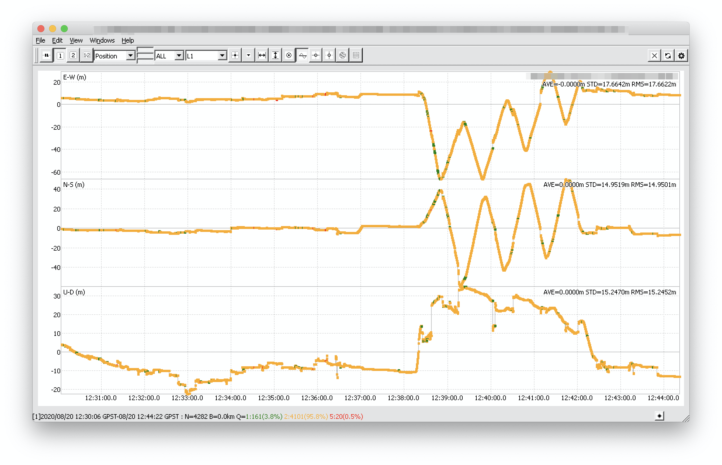
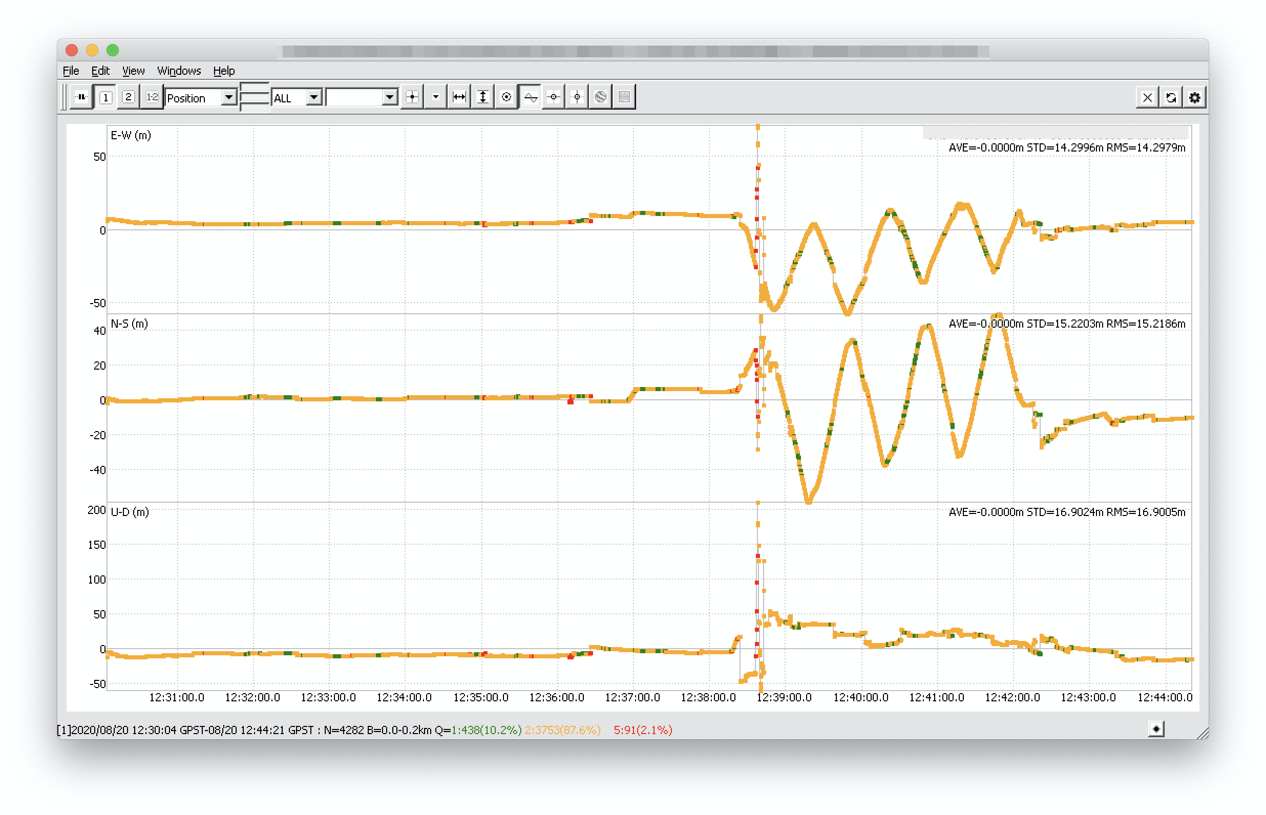
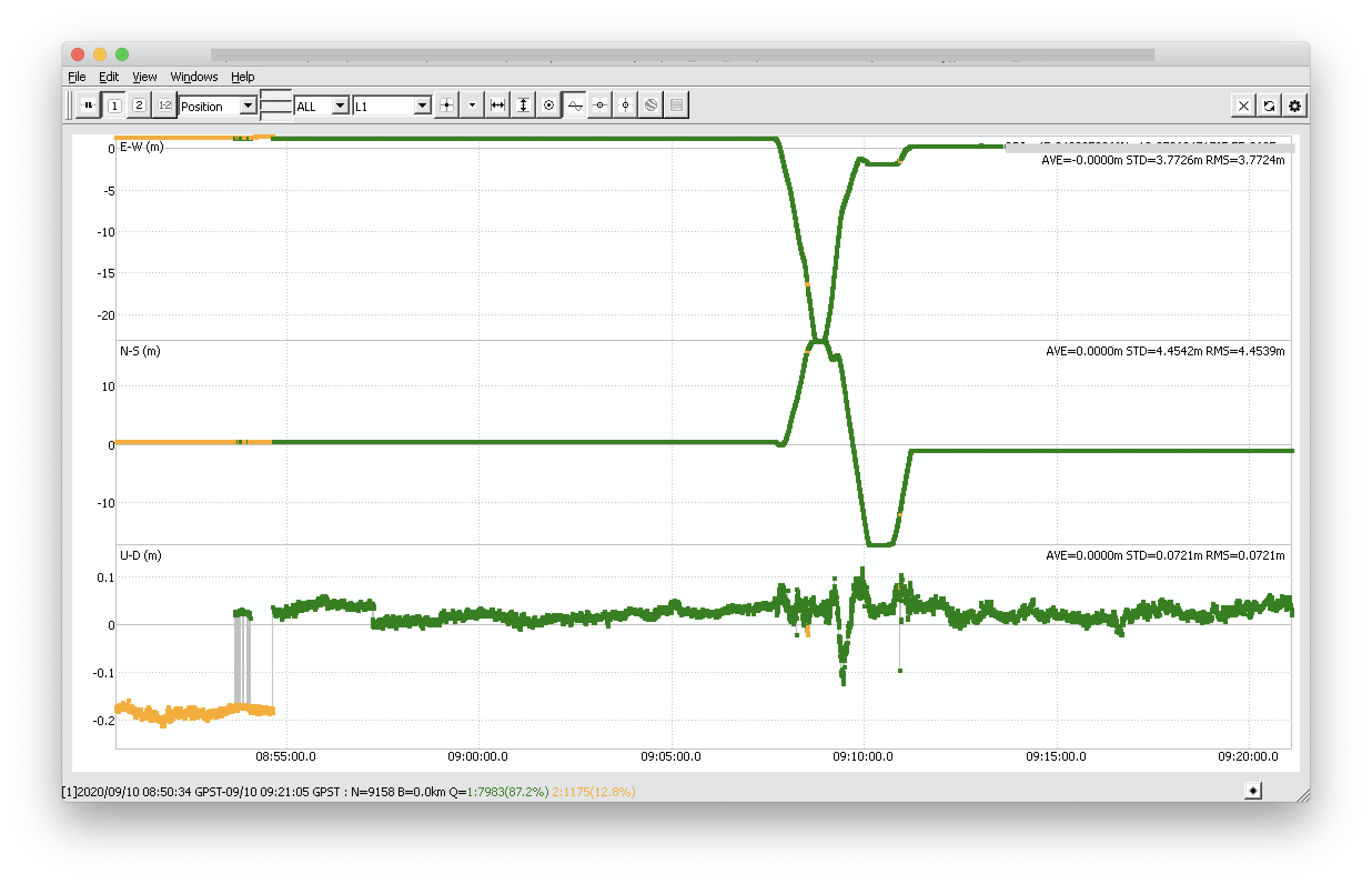
The altitude incorrect values since there is no solid Fix in the RTK and PPK solution. You can see on the screenshot below that there is 96% of Float in RTK and 88% of Folat in PPK.


Those issues are caused by the low quality of the observational data from the rover and the base.

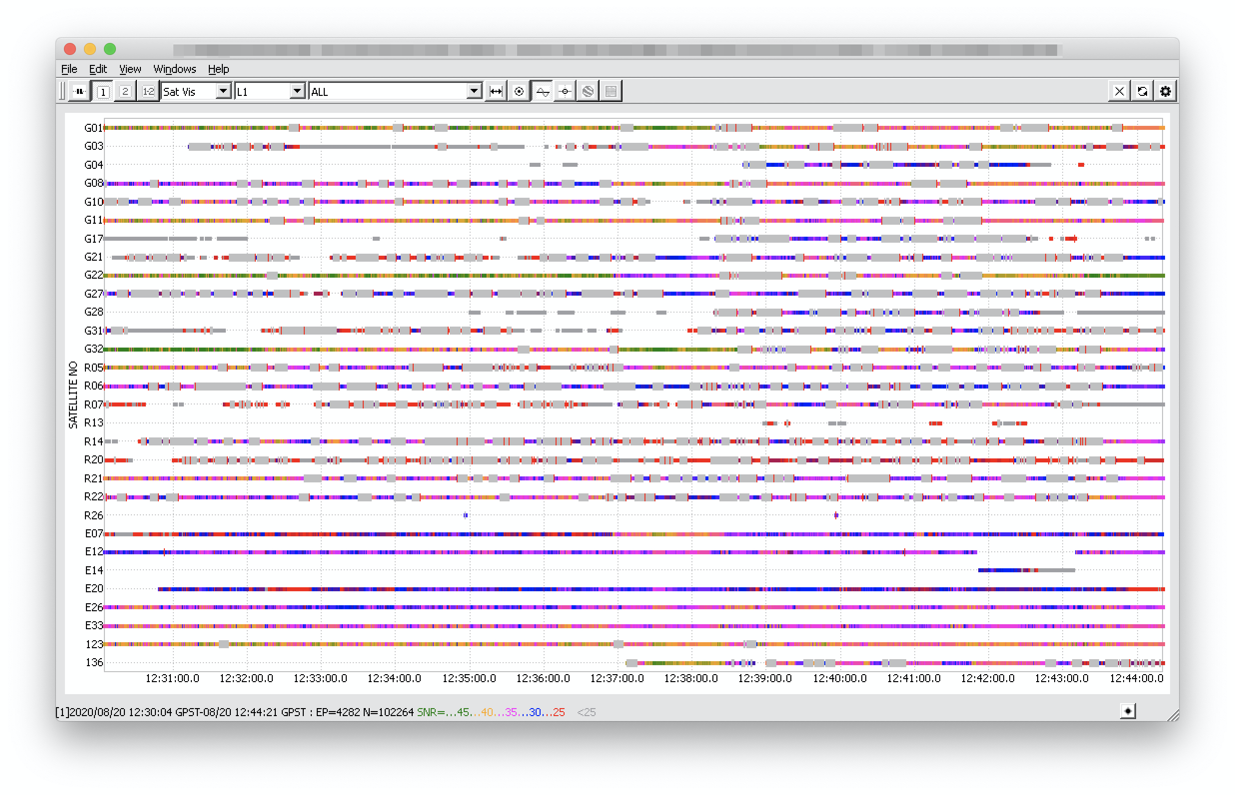
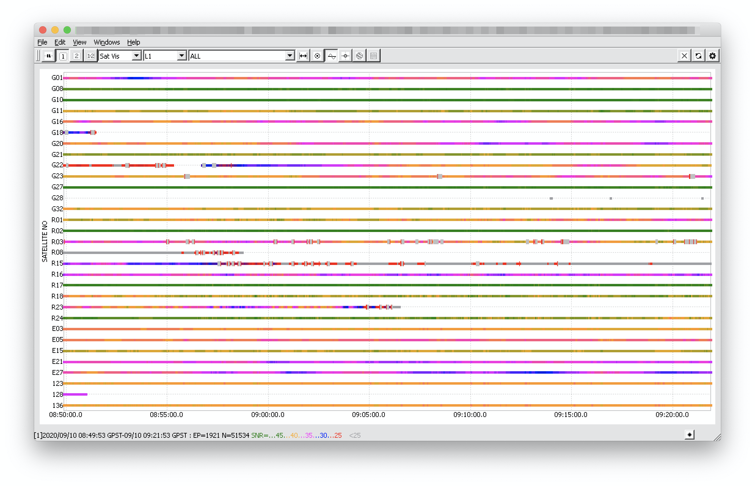
On the screenshot below, you can see the observational data from the rover. There is an immense amount of cycle slips and only a few signals have SNR above 40.

Such data quality can’t provide you with good RTK or PPK results. Usually, there are two main reasons why it happens:

  • challenging environmental conditions
  • the incorrect hardware setup

Let me address each below.

Environmental conditions

Reach M+ is a single-band receiver, so it’s essential to make sure that the receiver is provided with a clear sky view. Surveying with M+ in the dense forest or near electrical lines might cause significant issues with the observational data.

It’d be great if you could provide the photos of the environment you surveyed so that we could check it.

It’s also important to place the antenna correctly. Improper antenna setup can worsen the data quality even if the environmental conditions are good. You can check out our guide that explains how to place Reach’s antenna correctly for achieving better results.

Hardware setup

It’s important to keep the unit away from electronic components. If you’re integrating Reach in a complicated hardware setup with internal electronics, it can affect the unit’s performance. Please, share the photos of your setup so we could check it.

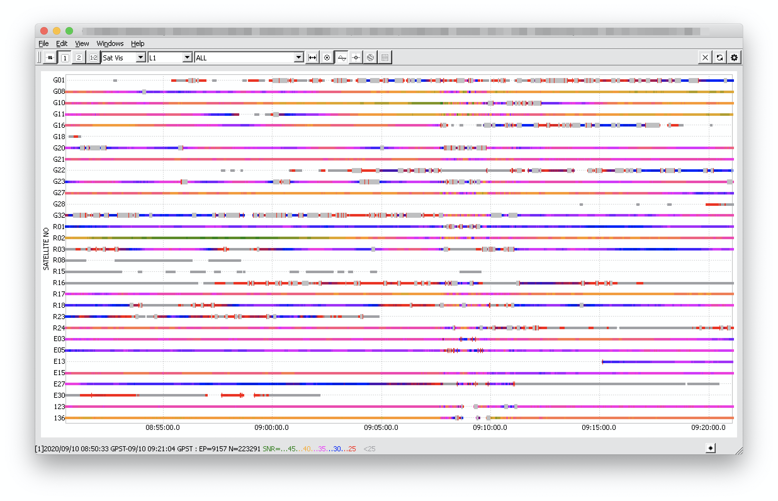
Also, in the base correction log, there are a lot of cycle slips there as well which might indicate issues with the receiver’s placement. Please check this guide on the Reach RS+ placement.

Moreover, we can see that the signal was disrupted. It might indicate that something got in the way of LoRa’s signal transmission. It’d be great if you shared the photos of the base’s placement so that we can check it and see if anything blocks the LoRa radio.

1 Like

Svetlana, i will provide you pictures. Just to better understand, can you tell me if BOTH rover and base have bad signal? or rover only? So i can better understand on how to isolate problem.
PS flight survey was in a sunny day with no clouds, in a open, rural area without obstructions, i cannot think better day/place to get a good GPS signal.
PPS do you think that power supply (5v bec) could lead to this consequences if power would not be “stable” enough, in your opinion?

Hi Steve,

At the moment, it seems that both the base and the rover had issues with the signal obtaining. It’d be great if you shared the raw data log from the base, so we could check it as well.

So this eliminates the issue with the environmental conditions. We can conclude that there might be an incorrect hardware setup.

I recommend revising the GNSS antenna placement on the drone. Reach M+'s antenna is sensitive to environmental interference. It has to be placed on a ground plane made of conductive material no less than 70x70mm. It should reduce multipath and provide better shielding. Also, try keeping all electronics as far as possible from the antenna.

I believe that with an unstable power supply your drone wouldn’t behave correctly. However, the close proximity of the power supply to the antenna might have induced a signal disruption.

3 Likes

Antenna is far from the power supply. I think we should continue privately so i can send you further info

Hi Steve,

Sure. Could you please send your files to support@emlid.com? I’ll take your ticket.

Hi Steve,

Have you had a chance to get the data from the receiver?

Hi Steve,

Thank you for the provided data! I’ll check it and write you back.

Hi Steve,

Thanks for your patience!

I’ve looked through the logs you shared with me. I can see that these data are from the other survey, not the one we discussed earlier on this thread.

RTK and PPK results improved in the new survey. I have attached the screenshots below. Now there are 85% of the Fix solution. The results are rather good. The Float status was at the beginning of the survey between 08:50 and 08:55 GPST.


The observational data on the base is fine. I see five satellites with a high SNR: G08, G10, G27, R02, R17. However, the rover’s observations share a fair amount of cycle slips, and there are no satellites with SNR above 45. Even though the rover observational data is not of such good quality, the receiver still was able to obtain Fix.


Is it possible that in your surveying area were electrical lines or other tall objects nearby? It seems that there is something that interferes with the GNSS signal the rover is obtaining.

hi Ludmilla,

no, there’s no power line or whatever, it’s a country place with open sky without structures apart a small house nearby.

Hi Steve,

Is there any chance you could share the photos of the environment you surveyed in? It’d be great to check where Reach receiver was placed.

1 Like

UAV is not in my hands right now, i will do it as soon as i get it again

Could you not just give us geographic coords to look at through Google Earth ?

This topic was automatically closed 100 days after the last reply. New replies are no longer allowed.