The receiver and the emlid survey pole arrived a few days ago, and after some tests comparing the measurements made with a HI Target V30 Plus Rover and with Reach Rx Rover using the same emlid survey pole, I noticed some horizontal and vertical differences between the 2 receivers .
The tests with a distance between points of 8 cm were performed on a fixed reference base at a distance of approximately 35 km and those with a distance of 6 cm were performed on an iMax 3.1 base from the same distributor.
From what I can see, hi target has approximately the same level differences, while with rx the differences are enormous between them.
The only difference is that for the measurements we used 2 different telephone operators, but both with 4G, COUNTRY : ROMANIA
The best way to understand what is going on is to do a test on a benchmark with known coordinates. Do you have one in your area? Can you collect it with Reach RX and share the results with me?
For curiosity you used the Rompos and where, why you do not use the messages with MSM 4 you pulled the engine brake at GPS, and more imported what software you used.
I will ask the moderator not to censure the message in Romanian
de curiozitate ai folosit Romposul si unde anume , de ce nu folosesti Mesajele cu Msm 4 ai tras frina de motor la gps , si mai importat ce Soft ai folosit .
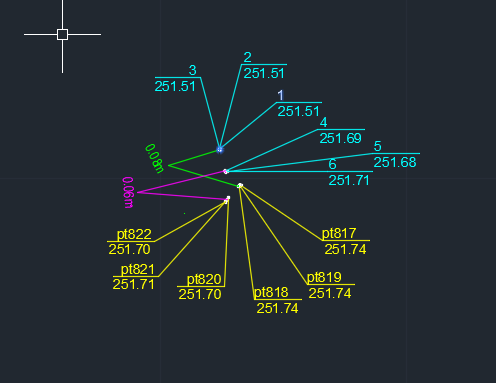
Hello, yes I used ROMPOS with iMAX 3.1 and Nearest 3.1 (pascani), as software for emlid I use emlid flow, and the hi target gps has Hi-Survey road’s software, I kept trying to compare them several times or with Syscad RTCM 3.2 and 3.0 and it still gives me differences between them sometimes even of 15 20 cm on the same network, the same stations, the same points. however, the fact that in the picture above, if you look at the level quotas for the RX rover, they are totally different from each other, and those from HI Target, even if there are 2 different stations, remained almost identical with a difference of 2- 3 cm.
RO- translate:Salut, da am folosit ROMPOS cu iMAX 3.1 si Nearest 3.1 ( Pascani) , ca soft pentru emlid folosesc emlid flow , iar gps-ul hi target are soft-ul lui Hi-Survey road , am tot incercat sa le compar de mai multe ori si cu Syscad RTCM 3.2 si 3.0 si tot asa imi da diferente intre ele uneori chiar si de 15 20 cm pe orizontala si 10-15 verticala ,pe aceiasi retea, aceleasi statii aceleasi puncte . totusi ingrijorator e si faptul ca in poza de mai sus daca te uiti la cotele de nivel pt roverul RX sunt total diferite si intre ele , iar cele de la HI Target chiar daca sunt 2 statii diferite au ramas aproape identice cu o diferenta de 2-3 cm .
Nu te baza pe emlid flow ,il folosesc doar pt configurare , pt lucru folosesc Surpad , syscad cu statia cu [ ] rtcm 32 msm , pascaniu foloseste glonas si gps ca corectii , asa ca ai comparat mere cu pere , nu tine .
setezi din emlid flow , corectiile pe bluetouh, la pozitie bluetouth pe nmea si cam asta e , la surpad te conectezi pe nmea cu bluetouth, setezi corectiile si nu uita sa bagi la inaltime setarile de la antena(dispozitiv ) , Pt Rs2 ai una ,pt rs+ alta, surpad gasesti demo la esurvey sau survx la syscad
In afara de setarile astea facute la proiectie , ce mai trebuie sa adaug, completez ? Sunt ceva fisiere care le pot adauga aici? si daca da de unde le iau?
I just wanted to say that all the calculations are carried out directly on Reach. So the app you use to collect the data doesn’t affect them. That’s why using a 3rd-party collector can hardly help if there is a difference in measurements.
Dorin, have you had a chance to run a test on a benchmark?
P.S. Please keep communication on the forum in English so that other users can participate as well.