i’m having trouble with coordinate system to convert…
so emlid supports WGS84 coords.
when i have observed a point i used average fix and it stored a point from my base.
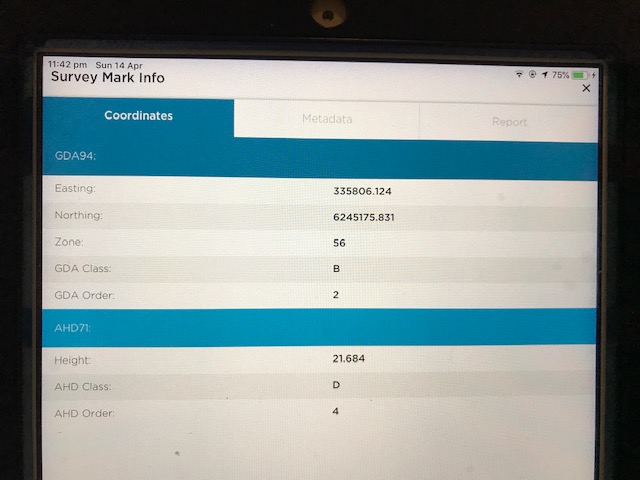
i have compared with actual coordinate its’ about 1-2m off which is fair enough because i didn’t put any coordinate and observed a bench mark with my base.
my current known coordinate system is in GDA94/MGA
so i think that i need to convert it to GDA94(actual coordinate) to WGS84 to put it in this RTKPOST
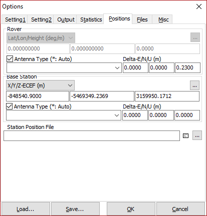
positions and base station input… to correct base coordinate.
do you guys know any converter to use? or what other method do i have?
I still do have a point i have observed average fix(base) and i can use that to process or i can put the real coordinate which is the actual bench mark coordinate after convert GDA94 to WGS84.
if i don’t put real coord there my survey will be all shifted 1-2m off because of my base coords all shifted isnt it?/
anyone know converter that i can convert GDA94 to WGS84 and WGS84 to GDA94??
this is what i’m getting at the moment, maybe i have selected the wrong coordinate system but from my understand GDA94 to WGS84. and i get really weird output coordinates…
thank you for your response! i could not select that zone 56 from GDA94. but you found it… i will try again see if i can view. i tried to type full GDA name and just GDA but that’s the only thing that’s close to where i can find. what about elevation? it’s not required to convert?
thanks!