RTK vs PPK fix discrepancy

I am using M2 as base and rs2 as rover in an RTK/PPK setup using lora. I made the two units stationary and once I get a fix on the rs2 I start going to a point of interest, stop and collect data for 15 seconds then move to the next POI and do the same. I made sure the indicator says fix before data are collected using the rs2. Data collection was done on 182 POI. Interested if the RTK points can be improved, I processed the log files from both units using emlid studio. The result indicated a fix was observed only on 32 points! Question: Why the drop in the number of points having fix status between RTK and PPK?

Thanks.

Can you share your raw-data? That would make it easier to help understand what is going on.

1 Like

Here’s the zipped rover and base .o files, base .p and the project csv. The file is apparently big as determined by the forum so have to upload it to gdrive.

Looking forward to understanding the discrepancy.

Thanks.

Looking into your data I have a few questions:

  • You have a lot of noise/cycleslips in your Rover data. This indicate breaks of the satellite lock, which can cause break of fix / not being able to fix.

  • Both observation-files only track GPS+GLO. In your case, also tracking GAL+BEI would probably have made more points be fixed.

On the discrepancy between RTK-fix and PPK-fix, then it seems the RS2 is sometimes making a false fix. This not uncommon for GNSS receivers in general. There are a few things you can do to minimize it:

  • When collecting points, pay close attention to the PDOP and the StDev numbers for each point. Anything above 2,5-3 cm on the vertical should be of concern. On your data, it seems you are hitting 5 cm.
  • You can set some more aggressive SNR and Elevation Masks (like 40dbhz and 20 deg).
  • Doing this will make it harder to fix under hard conditions, but, in my mind, give you a more trustworthy fix. Tweak the values until you are happy. One environment might be better off with one combination of settings, than your next environment.
2 Likes

Thanks for taking the time.

Generally, the drop from 179 rtk fix to 30+ ppk fix seems to be very dramatic! If there’s a lot of noise/cyce break shouldn’t rs2+reach3 NOT indicate a fix as it seems counter intuitive for it to still proceed with a lot of fix when algorithm wise it should not. I’ll try to breakdown points on which of the 179 rtk fix had the problem on the vertical. This also applies to the pdop and stdev. Definitely the stdev can be monitored within the survey measurement interface but the pdop is in the status section of the interface. One has to leave the survey tab go to status and then go back which sometimes is kind of difficult when in a difficult environment.

I tried using all 4 satellite constellations but getting a fix takes forever! When I narrowed down to gps and glonass, fix is more common than just standing in the middle of the field waiting for the fix status to happen.

False fix now that’s an interesting culprit. Need to understand that better.

I did another round on the same field to finish the inventory of trees. I did an overlap of the prior day inventory and as the base location was not the same as occupied before, I can understand why the overlap measurements were not spot on. I am assuming though that the geometry of the points will be similar for the two surveys. If you take a look at the image of the common points between the two surveys there are instances when the geometry could be discern as the same but two points were completely off (i.e., points 176 and 178). I can understand 178 as it was a float in the prior day and fix yesterday but 176 was fix in both! The solution files for the two day survey are attached.

Any thoughts will be appreciated.

Thanks.

Hi @rogerix20002000,

Thank you for sharing the data.

I’ll check it and get back to you.

Hi Roger,

I’ve checked the data you shared, and now I’m back to you.

First of all, I want to note that RTK and PPK results indeed may vary for the same dataset. It happens because of different algorithms of calculations. At the same time, PPK results may sometimes be improved: you can play with the settings and find a combination of them that gives you the best results.

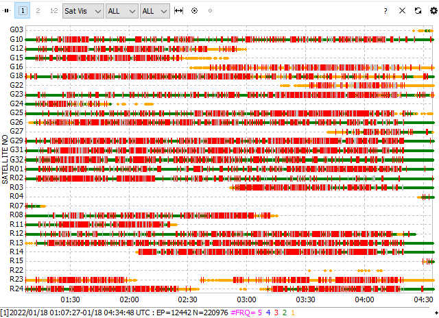
Nevertheless, I agree with Christian that logs from the rover are quite poor. I see numerous cycle slips, which means that the satellite signal was interrupted by obstacles. These are conditions in which we don’t recommend working even with multi-band devices.

When the conditions are challenging, it’s essential to check these parameters:

  • PDOP to be <= 2

PDOP shows the quality of the satellites’ geometry. In a forest, PDOP is most likely too high, which means the accuracy degrades.

  • Age of differential to be about 2 second

Age of differential shows the difference between epochs of the base’s and rover’s data. Increasing this parameter means that there are interruptions with the corrections stream.

  • RMS

RMS helps evaluate the solution’s changing. So it allows noticing its instability.

I’ll discuss with the team how to make checking these parameters easier.

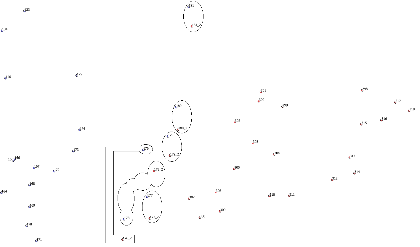
I see that 176 point indeed has a mismatch in 2 days, so it may look like a false fix. But to confirm it, we need to know the PDOP, Age of differential, and RMS.

If you face such an issue again, please enable the Raw data debug option, record raw data and solution logs, and share them with me. It’ll provide us with more info about the issue so we can analyze it.

UPD. Fixed the typo about AOD recommended time

1 Like

Hi @julia.shestakova Proper monitoring of these parameters in the field, especially in marginal conditions, would be a good subject for one of your excellent videos as well !

1 Like

Hi Dave,

I see this topic as complicated for a video, but I will pass your wishes to our video production team!

1 Like

I think they are up to the task. It sounds like best practice basics, but seeing the steps is very helpful for beginners (me).

Maybe hit up Rami Tamimi to share a run-through if not interested in-house.

For posterity, I will add that the best constellations to use in tandem for expedient, reliable results are GPS and Galileo.
Galileo was designed to be complimentary to GPS, and the combined constellation can essentially act as the same system.

1 Like

This topic was automatically closed 100 days after the last reply. New replies are no longer allowed.