I’m trying to get opinions from people using a pair of Reach RS+ for collection of points, bonus if you used it for ground control points.
My typical use case would be an unknown point for the base, observing over 4-8 hours for later PPP (NRCAN) to get the coordinate. Future visits to site would be sped up since the base would now be on a known point. Then, the second RS+ as a rover to go and survey points. Baseline between rover and base <3km typically.
I have 5 questions for you:
What accuracy could I expect from my points with a base over a point observed for several hours?
1a. What accuracy can I expect from the points gathered using the RTK solution if the base is on a known point?
What is the process to apply the corrected base position after PPP to my surveyed points with the Reach RS+? I used Trimble R8s in the past and I would use NRCAN for my PPP, then use the Trimble tool to calibrate my ground control points with the now-known base position.
Has anyone compared the RS+ and the M+, since they don’t (I assume) use the same antenna?
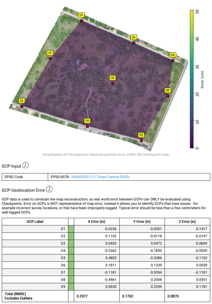
Would anyone that used a pair of RS+ for a drone mapping project be willing to share the GCP accuracy info and processing report with me?
This is my immediate thought. If you’re doing ground control points then what are you going to consider accurate? If you are doing sites repeatedly then do you really need true global accuracy? If all you need is repeatable relative accuracy you can quickly average a point in about 10-15 minutes and then enter that value manually the next time. Also if you are doing projects such as construction sites be aware that the coordinate system that the construction site uses probably isn’t a true grid coordinate system. As for repeatable accuracy whether you are on a known point or not you should be able to get within 5cm easily with RTK.
With a proper mounting configuration the M+ is just as accurate, but in my experience did not have quite the range that the RS+ had. Maybe in order of 75%.
Most of the points that I have shot stake-out within 2-3cm and when you’re talking about a processing report they are nearly perfect because of what those values actually mean. They are usually within a 1/4in (0.02ft). As you can see from the report below, D5 was probably human tagging error.
If you already have RS+ receivers then go for it, but if you have yet to purchase then seriously consider RS2’s instead. Depending on your environment (large sites, trees) the cost increase will pay for itself quickly. We still use our RS+ for PPK droning, but the RS2’s now do all the surveying and setting of GCP’s.
What accuracy could I expect from my points with a base over a point observed for several hours?
If you collect data with a standalone multi-band Reach RS2 or Reach M2 unit for at least 4 hours and process it in a PPP service, you can get a point with absolute centimeter accuracy. Please note that with a single-band unit you can achieve submeter accuracy only.
What accuracy can I expect from the points gathered using the RTK solution if the base is on a known point?
Other points will get absolute accuracy. If the solution status is Fix, they will be centimeter-accurate as well.
What is the process to apply the corrected base position after PPP to my surveyed points with the Reach RS+? I used Trimble R8s in the past and I would use NRCAN for my PPP, then use the Trimble tool to calibrate my ground control points with the now-known base position.
After you get the position from a PPP service, you can set it in the Base mode tab before collecting points. At the moment, the only way to apply the offset to the existing points is to upload the data to a 3-rd party software.
Has anyone compared the RS+ and the M+, since they don’t (I assume) use the same antenna?
Reach RS+ and Reach M+ have the same GNSS chip, so they both have the same positioning:
Take into account, that your setup, based on Reach M series devices, won’t be really accurate, because you have to place them really precise on your GCP’s. Since, you will have more or less DIY solution, I doubt it can be done so. Of course, it depends on the precision you want to achieve.
If you mount the antenna on top of a survey pole it’s really not any harder than screwing on a full-size receiver… Just cut the threads off of one of the old 5/8" - 1/4" brass adapters, mount it and measure the height.
I think you are assuming that I will simply put the M2 on the ground? I will be using Harxon GPS 500 survey grade antennas, as well as a survey tripod, extension and tribrach for the base, and a survey pole for the rover.
I was assuming, that you will fix the M2 with the duct tape on the pole, or use the famous Tupperware food container. Now I see, that you are more professional! Please, share the results. It would be really interesting!