We are a company in Switzerland and are supporting a student doing a master work in the area of Frankfurt, Germany. For this we need a RTK correction service. If somebody from Germany is reading this and knows of a rtk service please let me know. We need the service approx. until August 2022.
Thanks Roland
PS: @Emlid, if you do not want this kind of messages in the forum let me know.
Your post is fine! This community is, among other things, for sharing experiences between our users. And we are glad that this is the place you came for a bit of advice
you can use the RTK service SAPOS of the state of Hessen.
It is free of charge, you just need to register. You’ll gut your login data within 3-5 working days.
The following link directs you to the SAPOS webpage of the state of Hessen, it’s in German. SAPOS (hessen.de)
It might be a little more accuracte than the EUREF NTRIP caster because of the total number of reference stations and their shorter base lines.
No matter whicht mount point I use, the reachview3 app, on the ‘Correction input’ Screen is constantly switching (every 3 seconds) from ‘Connected’ to ‘Read Error’.
Which mount point do you use with an RS2?
Any idea what could cause this problem?
If I uncheck 'Send NMEA GGA messsages to the corrections provider… ’ I do not get the ‘Read Error’ anymore but now it is switching between ‘Connected’ and ‘Waiting…’ messages. The ‘Connected’ message stays longer until the ‘Waiting’ message pops up again.
Thanks Roland
PS: While I did this test I’m in Bern (Switzerland).
to answer your question quickly: Switzerland might be the problem.
Sapos Hessen covers only the following reference stations https://sapos.hvbg.hessen.de/refmap.php.
So when ever you’re close(er) to Hessen, it should work. They will you the surrounding reference stations of the other German states when ever you are close to the (state-)border.
Here some additional thoughts, only to check if you have considered everything.
which coordinate system do I want my points?
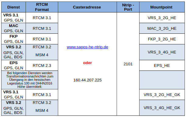
the first 5 will give you coordinates/corrections for ETRS89/UTM 32N
the last 2 will give you the coordniates/corrections via a transformation messege for Gauss-Krueger DHDN
I would go for VRS 3.2, because it’s using the four major satellite system the RS2 or M2 is also able to use.
The setup in RV3 shoudn’t be to difficult.
Adress: www.sapos-he-ntrip.de
Port: 2101
user name: XXXXX You should have received your username and password wirh the other details.
Mountpoint: VRS_3_4G_HE (in case of VRS 3.2)
Sent position: yes
and that’s it. You should be good to go.
You might need an additional SIM Card to get mobile data to communicate. It might be too expensive to communicate with your swiss card.
Data capuring has worked without a problem. Thanks for all the information.
Now the student has sent us the polygons for the turf pitches he wants to observe in Gauss Krüger CRS (EPSG: 5677). But we need them in WGS84 (EPSG: 4326). The transformation in QGIS supports an accuracy of 1 meter only. Do you know of a service or tool where we can transform the polygons (shape or dxf) with higher accuracy?
Did he measure in GK (5677)? And did he choose the right correction message?
First you should consider what accuracy you really need.
The transformation from ETRS/UTM to WGS84 would be way easier, because you could skip the datums transformation (almost identical parameters)
I would recommend to transform from GK to UTM with the HeTa2010 (Weltweite Sammlung von frei zugänglichen NTv2-Dateien)
This is the way to get the most “legal” coordinates for example for legal surveying at this point in Hessen. To be honest the BeTa2007 Transformation should also be fine, the differences are about 2-5 cm in most of Baden-Württemberg in my experience.
If you export your points as a CSV there should also be the coordinates in lon, lat and elevation so you can check if your transformation works.
To transform points into different coordinate systems in Germany you can also use the point based transformation tool of the BKG (BKG Koordinatentransformation (Anwendung))
Aparrently we do not have a tool to transform polygons or line like you have in Switzerland as far as I know, at least no open source one.
FME Workbench might be a tool you should consider.
It’s free to use for students and non profit use. You can do as many transformations you like and you can redo them as often with a variety of dxf/shape files.
Thank you very much.
Since the polygons the student is using have all a rectangulare shape I can use the point based transformation from the BKG to transform all corners of the rectangles and re-create the polygons in WGS84.
I’ll check out the FME Workbench too.
“Did he measure in GK (5677)?” → yes
“And did he choose the right correction message?” → I hope so.