I have two RS2+ receivers. I have set one as a base station and logged it’s position for 24 hrs and then processed those results using the CSRS-PPP website. I waited a week or so before uploading to get the most accurate coordinates. I am in the UK so requested the coordinates in ITRF2020 coordinate system.
I have read that I have to convert from ITRF2020 to ETRS89 but after converting the coordinates given from the CSRS-PPP report there was no change. So, inputted these coordinates manually as my base station coordinates and connected the base station RS2+ to send the corrections via Emlids Ntrip caster to my rover over wifi.
I am able to pick up the corrections on my rover using a data only sim card and recieve a fix in very little time.
The problem I have is that I am on a building site which has been set out from known datums, ie various datum nails that I assume were coordinated via a survey grade GNSS reciever by the intial survey company. I am setting out drainage and roadways using a total station, with the view of using the more durable and weather proof RS2+ for kerb setting out and doing road level topos. I inputted the E,N,Z of the known datum nail as a point in the emlid flow app, but, when I set up my rover over these points with known E,N,Z the rover is saying I am around 700mm in the wrong place.
I have tried different coordinate transformation sites to go from the CSRS-PPP reported ITRF2020 to ETRS89 to OSGB1936 but cannot get it spot on. Starting to think that the intial datum nails were put in with an error and the whole job and site control points were taken from them. But, given me being very new to GNSS it is more likely that I am not converting the coordinates correctly somerwhere along the line and that is whats causing the 700mm error.
These are the websites I have been using to convert the CSRS coordiantes for my base station.
If there are any users out there who have setup a base station using CSRS and set out on jobs using the OSGB1936 coordinate system please could you help me with your workflow.
Your intentions are correct. Converting ITRF2020 coordinates from CSRS-PPP into ETRS89, and then apply projection to get OSGB36 coordinates.
ITRF2020 is currently separated from ETRS89 by ~80 cm in London, and growing because of the tectonic activity of the Eurasian plate. So when converting from one datum to the other, you should see a difference. The first website you used is not suited for that because it does not take into consideration the plate velocities. Actually, to be rigourous, you also need to know what frame of ETRS89 you need. ETRF2000, ETRF2014 ? It is not clear at all what Ordnance Survey actually uses. And the results of the conversion can differ by 4-5 cm depending on which you use.
So, let’s go to the point For the ITRF - ETRS89 conversion, you can use the official EUREF tool here. It makes use of the Boucher & Altamimi, 2018 note. Inputs are in ECEF-XYZ format. Select the feature without velocity. Then you can use the OS conversion tool to get OSGB36 coordinates.
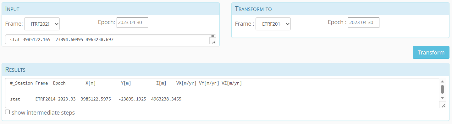
I tested after post-processing TEDD station, near London, on Apr 30 24h session.
ITRF2020 results
X 3985122.165 m
Y -23894.60995 m
Z 4963238.697 m
ETRF2000 results
X 3985122.6338 m
Y -23895.1504 m
Z 4963238.2911 m
ETRF2014 results
X 3985122.5975 m
Y -23895.1925 m
Z 4963238.3455 m
OSGB36 results (from ETRF2014/ETRS89 results)
Easting 515261.781 m
Northing 170887.624 m
Height 24.341 m
Update : according to these results, and compared to the official coordinates of TEDD station published by OSnet, OS uses ETRF2000 as ETRS89 frame. So you may want to use this one in the EUREF conversion tool.
Thanks for the reply and interesting info regarding the growing difference between ITRF2020 and ETRS89 Florian. I followed the process and used the EUREF tool and for whatever reason my base station position is a few km away from its actual position. I had to convert the CSRS lat and longs to decimal in order to input into the EUREF tool so maybe something went wrong here. I’ll have to check the inputted coordinates and run the process again.
I’ll use ETRF2000 and see if that makes a difference as per your update.