As I read in this post- RTCM transformation
RV does not support RTCM transformation for now.
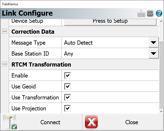
As I mostly use Fieldgenius and connect to the NTRIP network using FG also, I wanted to use RTCM transformation sent from the provider. This way I’m connecting to the NTRIP network through my controller internet using FG.
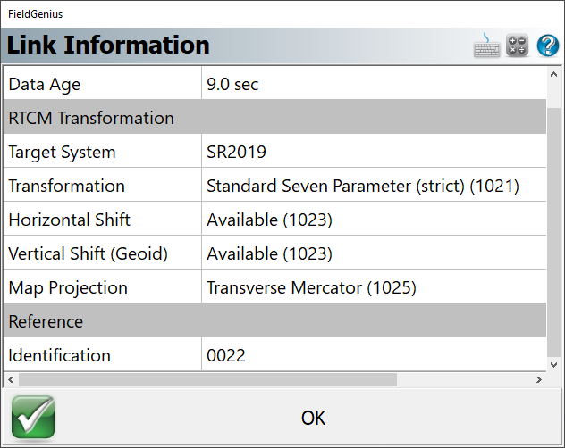
The transformation from WGS84 to official datum in my country (Serbia, MGI Balkans zone 7, Gauss-Kruger projection ™, central meridian 21, orthometric heights) should be done in 3 steps:
7 parameter datum transformation
horizontal GRID shift
vertical GRID shift
I’m connecting to the NTRIP network using these settings:
No, there are 2 providers, and the base station’s coordinates are WGS84.
Officially, we have to use “PAID ” online service called GRIDER and transform measured points from lat long elips.h (or UTM-34N E,N,h) to State coord. sys GK7 with orthometric heights.
We do this by uploading .txt files with point-ID lat long h and then downloading the transformed .txt file. And this is a pain in the …
One of the providers (Oficial Leica distributor in Serbia) additionally offers real-time RTCM transformation to State coordinate system, by connecting to Mountpoints with _CS suffix in mount point name. (This can not be used officially if you are submitting your survey to the cadastral office, but we can use it for other works)
My friend has Leica GS08+ and he gets transformed rover position when he connects to any of _CS mount points that are emitting transformation in RTCM message.
As I thought, the coordinates are given in ETRS89.
Names of permanent stations, data on installed receivers and antennas at stations and positions of stations “GeotaurNet - powered by GentooARS” (first phase) of the network in the Serbian Spatial Reference System (SRB ETRS89) are given in the following table.
There are a few free and paid online services, apps, and CAD add-ons that can perform the same transformation as state-owned money-hungry GRIDER.
But the only official tool is the so-called GRIDER service.
I compared results from other tools to this official one, and mostly residuals are in a range from 0 to 1 cm


 ” online service called GRIDER and transform measured points from lat long elips.h (or UTM-34N E,N,h) to State coord. sys GK7 with orthometric heights.