


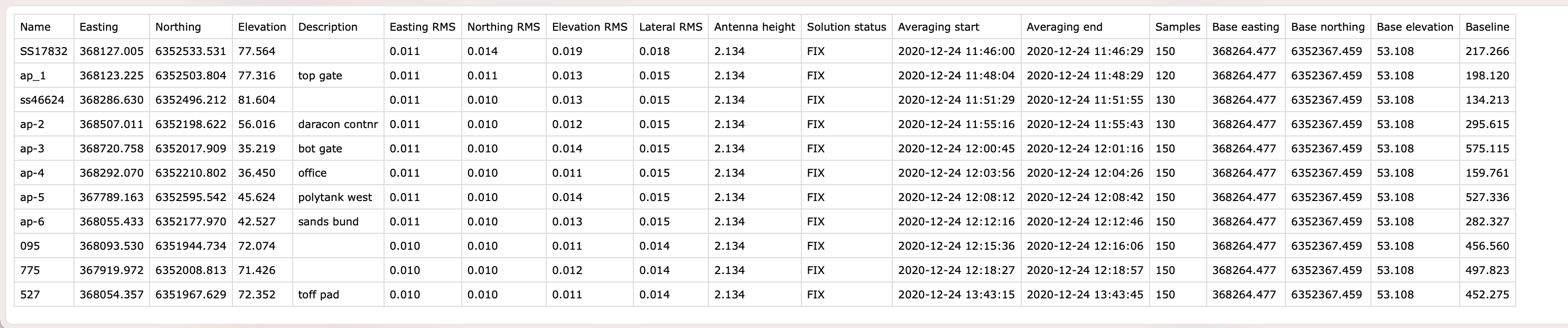
With regard to the columns, is the ‘base elevation’ the phase centre or has it taken into account the tripod height (user entered) point on the ground?
I am assuming the rover elevations have taken the pole (2.0+0.134) into account.
Thanks
You can also find a local (documented on surveys and engineered or construction plans) or NGS benchmark to adjust your survey to after the fact. Just let the base average for 15-20 minutes and localize like @Sam_DeLong suggested.
1 Like
No, base does not take into account the pole. If your burning a point for 20-30min and you set back up on that point set pole height to zero.
1 Like
Set it at whatever you shot it with. With our systems all bases are 6.56ft or 2m as to remove confusion of what the next person should enter because it is already entered from the equipment setup. Even permanent base poles are shot in as 6.56 because that’s where the pole already is regardless of the height of the base pole.
Hello and Merry Christmas to all. I’m the original poster to this thread and I’d like to get some feedback on my more recent findings. Let me start by saying i’m not a surveyor but I’m being called on to perform some duties that a surveyor would perform.
when working on road layout projects i can always find a control point so when I’m gathering data i can correct any misalignment by moving the field collected points in CAD to the reference of the control point. where i got a real wake up call was when i was asked to stakeout a property line. My initial training with the Emlid system consisted of 15 minutes in a parking lot learning how to connect the Rover to the Base and then recording various points in the parking lot. i was under the impression that after 5 minutes of the base picking up readings from the GPS satellites that the Base unit was properly located. This is false. i discovered this fact when my property line stakes were disturbed and i had to return and re stake them. those that were not disturbed were all exactly the same distance and direction off from my original stakeout.
My question is this: Is it possible for the Base unit to become accurately positioned by GPS alone and if so how long does this take and how do you know when this has been achieved? What kind of accuracy can be expected by using just GPS as opposed to NTRIP?
Sorry for this long winded question and thanks in advance for any replies.
You can,
- Use a known point to manually enter a base coordinate to be either globally positioned or site surface coordinate relative.
- Use NTRIP to be globally positioned or site relative if the site is on global coordinates in a one-to-one scale factor.
- Average in a base point for one-time use or document the averaged coordinate for manual entry and relativity on return visits.
Another scenario that comes up allot in construction is localization or sometimes called site calibration. This disregards the coordinate system and relies upon ground monumentation for a best-fit positioning. This is similar to resecting a total station setup. Localization also takes into account any scale factors that may have been applied to information derived from CAD files.
1 Like
Hi Frank,
Is it possible for the Base unit to become accurately positioned by GPS alone and if so how long does this take and how do you know when this has been achieved? What kind of accuracy can be expected by using just GPS as opposed to NTRIP?
To determine the precise position with a standalone GNSS receiver, you can use the PPP technique. A single receiver might get centimeter-accurate coordinates using only its own raw data, precise ephemerides, and clock offsets provided by a PPP service. With NTRIP corrections, the receiver can achieve centimeter-level accuracy as well.
For PPP, you need to record a raw data log for a few hours and then post-process it in a PPP service such as NRCAN or AUSPOS. After that, it is possible to download a report and check the estimated accuracy. Please note that we recommend collecting raw data for at least 4 hours to get high-level accuracy.
Hi Troy,
is the ‘base elevation’ the phase centre or has it taken into account the tripod height (user entered) point on the ground? I am assuming the rover elevations have taken the pole (2.0+0.134) into account.
Yes, you’re right. The rover’s Elevation field takes the Antenna height shown in the Survey tool into account.
The Base elevation field contains the coordinates received from a base station. When you set the position in the Base mode tab, you have the following options:
-
If you input the coordinates of a known point manually, you need to enter the Antenna height. Then, it will be taken into account to calculate the precise height of the base unit antenna.
-
If you average the base position, the height of the instrument is automatically taken into account, as the position of the antenna is measured. So, the base elevation is correct without entering the Antenna height value.
[quote=“chascoadmin, post:31, topic:21940, full:true”]
You can,
- Use a known point to manually enter a base coordinate to be either globally positioned or site surface coordinate relative. This I understand and I believe I can learn how to do this with the documentation.
- Use NTRIP to be globally positioned or site relative if the site is on global coordinates in a one-to-one scale factor. Since the only NTRIP available in our area requires an expensive subscription and I would rarely need this function this is not looking like a viable option for me.
- Average in a base point for one-time use or document the averaged coordinate for manual entry and relativity on return visits. I believe this is what Kseniia is describing below. it sounds like this would require two trips to the site, the first to gather the log information and then after post processing, a return trip to set the Base up in the exact location as when the data was collected and then points could be staked out. Is this what you are describing?
Another scenario that comes up allot in construction is localization or sometimes called site calibration. This disregards the coordinate system and relies upon ground monumentation for a best-fit positioning. This is similar to resecting a total station setup. Localization also takes into account any scale factors that may have been applied to information derived from CAD files.
[/quote] Not really familiar with the terms “Monumentation” and “Resecting a total station setup”. Would this be just picking an arbitrary point as a control and then have everything referenced to that arbitrary point?
Kseniia,
Please see my response to Michael above. It seem like the PPP method will require two trips to be able to stake out pre defined points like a property boundary. Is this correct?
I agree. It is possible that there is also a source that publishes those corrections that you can download. In Texas the DOT publishes their hourly RINEX files that we can use, but they won’t let us use the network live. Like PPP though this would require post-processing before work could be done.
Monumentation is just a blanket term we use for control whether it be benchmarks, property pins or traverse points left by other surveyors. Resecting is sometimes called free stationing where the instrument is in an unknown position that can become known as it is triangulated using two other points.
Localization is essentially the same thing where the base station is put in a arbitrary position with a fake or averaged coordinate which is close to the site coordinates and then three (preferably four) points that mostly encompass the area to be surveyed are observed and the error between the provided coordinates and the positions of how they actually relate to each other on the ground is prorated in the software. The base will then always occupy that point with the same coordinates entered. This requires special software functionality like Microsurvey FieldGenius. Brands like Topcon and Trimble allow you to occupy new points that have been surveyed in using that localization by “starting the base” on one of those points. Reachview sometimes has trouble starting on a new point if the observed coordiante based on the faked or averaged point is not close enough to what it thinks is reality.
This is a standard method in construction because not all CAD files are the same or on true grid coordinates and at the end of the day all we are concerned with is that the design we are building is inside the limits of the allowed area.
3 Likes
Thank you for taking the time to reply to my posts. This gives me more to think about…
1 Like
Hi Frank,
It seem like the PPP method will require two trips to be able to stake out pre defined points like a property boundary. Is this correct?
Yes, you need to collect the log first and return to the site after the base coordinates are determined.
Please note that PPP services need some time to get more data for precise calculations. So, it’s better to check the desired accuracy with the service to understand how long the delay can be. For example, NRCAN CSRS-PPP service can calculate the data in the following modes:
-
FINAL: ~2 cm accuracy, available 13-15 days after the end of the week
-
RAPID: ~5 cm accuracy, available the next day
-
ULTRA RAPID: ~15 cm accuracy, available every 90 minutes
PPP allows determining the base position with absolute accuracy. After the base position is calculated, you can collect as many accurate points as needed with a rover unit.
Hi Frank,
You could carry out Post-Process of the Rover data that occupied the control point you’re trying to establish against the Rinex data of a Base Receiver on a survey mark or benchmark with a software like TBC or RTKLib on your PC or Workstation on site or in the truck after your say 2-4 hours of observation, and carry out staking out with the second half of the day.
If you are not comfortable with the idea of the pressure that could come with this kind of work flow you can go back in the following day to do your work……another way we carry out surveys is to use a total station to resect from rough coordinates and then carry out static observations of those points for a couple of hours and then geo-reference the entire drawing or measured points with the postprocessed coordinates of the control points we used to resect.
1 Like
Michael, could you explain or provide any literature to explain scale factor in the workings of GNSS.
Hi @tisijola, sure! The scale factor comes into play when you are transforming data from a Geodetic coordinates system to a Cartesian system. Basically it is the percentage difference between the slope distance from Geodetic versus the 2D horizontal distance of a planar Cartesian system. In the United States we use State Plane Zones that use YXZ and specific coordinate ranges for each zone. When you compare the slope distance of the Geodetic coordinates against the YX values when the grid plane is overlayed on the spherical our distances usually need to be upscaled by a very small factor around 1.000012, but considering our area is 10,000,000ft Y and 3,000,000ft X from the origin the shift northward would be about 120ft.
The scaling on the site is obviously much smaller from point to point, but does make a considerable difference on something like long roadway projects. Example being that 10 miles of roadway would show that a 52,800ft measurement on a Cartesian grid and the scale factor above is actually 52,800.63ft as measured with GNSS.
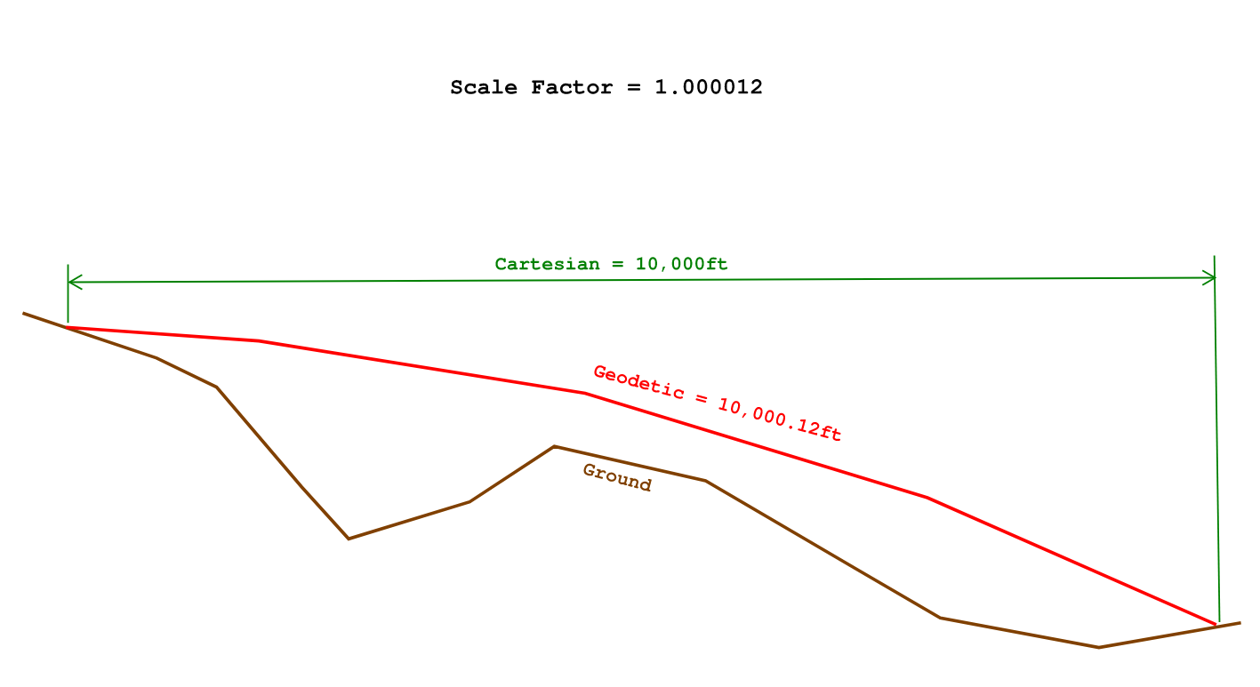
In our scenario GNSS points or drone data transformed 1:1 from WGS84 to Texas State Plane Central Zone will come in south of the CAD and have to be scaled up to align.
1 Like
@michaelL I am left with more questions.
Coordinates gotten by GNSS observations that are in permit me to say if I’m right, my Projected Coordinates System [Minna UTM 31 & 32, Nigeria] are Geodetic?
I understand the illustration from a previous explanation of refraction of distance measuring laser light in afternoon air medium vs morning or evening air medium when using a total station EDM. The effect of temperature over long distances.
In what scenario would I need to introduce a scale factor? CAD to Ground? Grid to Ground?
1 Like
UTM coordinates are cartesian. Depending on the kind of work you are doing and who you are working with will determine whether or not the data ever gets scaled. People often don’t scale when they should. It may be different in your region or country as well. In the past in the U.S. I saw allot of surveys that were not scaled so the oddity was one coming through scaled and us trying to figure out why it wasn’t working and then the light bulb comes on. Now 99% of the Surveyors and Engineers in our area are scaling their work.
You may be on the right line of thinking, but the drawing and explanation have nothing to do with light, temperature or air density, but moreso the actual measurement differences between Grid XY, GEOID Surface and Ground Slope distances which are all definitely measurable whether it be GNSS, optical instrument or measuring wheel.
This doesn’t take into account any vertical scaling, but that very rarely ever makes a difference unless you are doing some monumentally big work. In construction it doesn’t matter one bit because our vertical datum is ground-leveled and predetermined regardless of what the GNSS says.
1 Like
Tisijola,
Does the software that you mention use a different set of data than what Kseniia is referencing in the above post? If not do you agree with her level of accuracy loss/time interval stats? Or in other words the longer you wait to compare to the NRCAN the better your accuracy?
Yeah it uses it although it’s a different situation I’m describing which is when processing against static observations from your base station on a survey mark or a Geodetic Control, when using software like TBC you can also use the internet download function to get the different data that is provided by IGS I think: Rapid, Ultra-Rapid and Final orbits for GPS and/or GLONASS. This is something PPP services definitely take into consideration as @kseniia.suzdaltseva pointed out earlier.
I am sometimes confused when I convert static data to rinex from my Hi-Target unit and I get both a rinex file and ephemiris data which is somewhat strange since its as if its downloading it real time as you’re logging static data.
I am left wondering if static data from base stations are embedded with ephemiris data.
Maybe @kseniia.suzdaltseva can shed light here.
1 Like