Firmware v2.23.9 and ReachView 3 v4.11 Beta.
I tried different apps: RS2 Web interface, Reachview 3 and FieldGenius for Android.
Used different NTRIP Casters: BKG IGS-IP.net and SAPOS M-V as VRS.
I am a civil engineer and recently purchased my first RS2.
Soon we had a project where we had to measuring some manhole cover on the streets. These where covered by a official surveying plan with “official” heights.
Surprisingly they differ from the with the RS2 measured ones. All measured values differed about 0.8 metres. First i thougt about a mistake. But a colleague which is a graduated surveyor suffers the same experience at another project. Also there the differences where about 0.8 metres.
We spoke an brainstormed about getting a solution and checked every setting twice. But no solution.
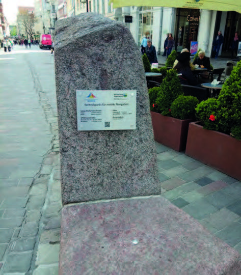
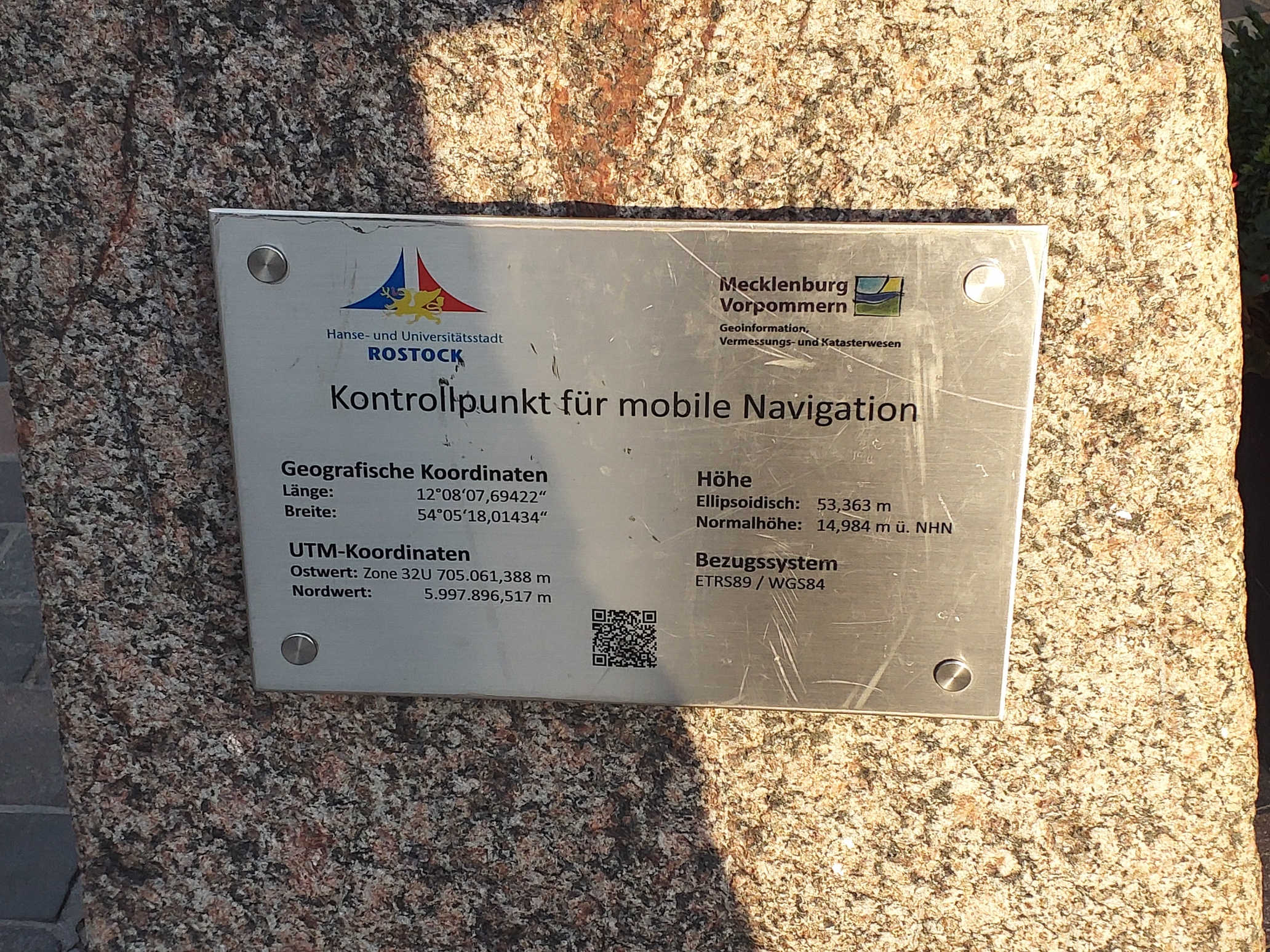
Luckily we have a official survey point in the center of our town since 2019, where the official ellipsoidal height of this point is written. I decided to just measure this height on the point to exclude all tranformations as a reason for our issue.
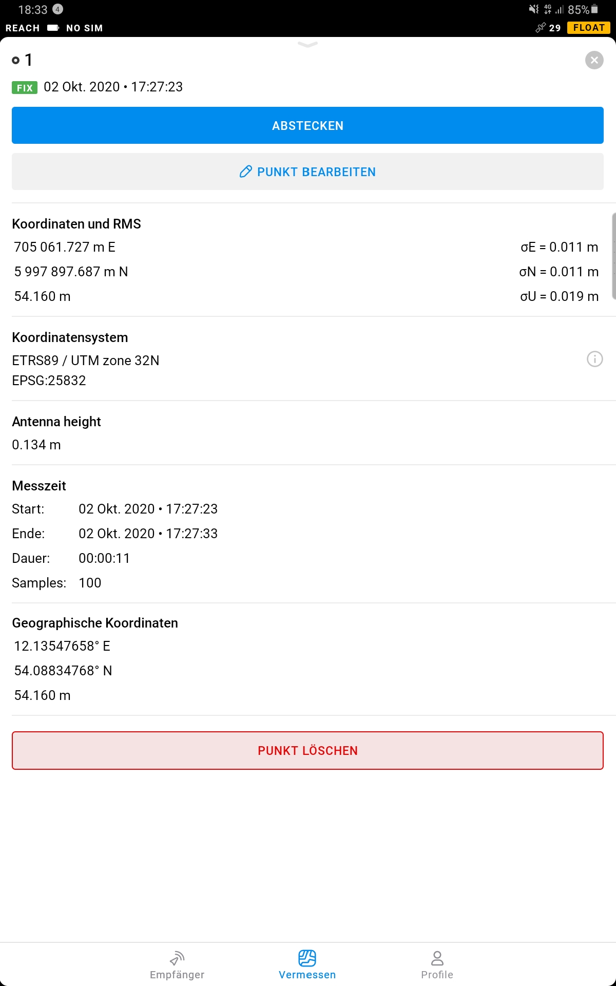
The result was not as expected: Also the measured ellipsoidal height on this point differs about 0.8 metres. It should be 53.363 m. I measured 54.160 m.
I did not use a pole, instead i set up the RS2 direkt on the measuring point (considered in the app).
How can it be? Can it be, that the RS2 is not calibrated some how?
I would be glad, if anybody can help to find a solution how to get the right values!
I have nothing recorded. I just can export to csv. If it really helps to solve the problem i can record the files at another journey.
If so, i would be glad, if you point me how to record the files.
If you make another run, it would be quite interesting to have the raw-files.
I think your problem is rooted in that the base coordinates transmitted are not ETRS89. However, those are supplied from i.e. Euref, and can easily be used for post-processing.
It probably just means that your NTRIP caster is sending elevations that are different from what was used during the MH survey. I see a difference in elevations due to different geoid models used in the 2 different surveys. Unless you have more info on how the MH got their elevations, I would just adopt the present MH as correct for your survey purposes.
According to the survey control point, geoid separation at this place is 38.38 meters, so the 0.80 cm difference can’t be related to a ellipsoid/normal height error.
Do not assume. I thought mine was WGS84 and found out this year it is NAD83 (2011) they also use a different datum for height. Sorry couldn’t find it this AM
I have never post processed. Not needed in my application. Everything is relevant to the the base and the survey I do on a job site.
I found the difference in datum when checking the RS2 for accuracy. I am using the Ohio CORS network for correction, found a local survey point and did a 15 minute average. X/Y came out extremely close, Z was off some. When researching I found the different datums. Never did post process to see what it came up with. Thought about it but, I am in my busy season and time is very limited right now. Good winter project.