Using an RS2 as a base and Emlid Caster to broadcast corrections
I have the caster connected to another RS2 as well as a Bad Elf Flex. I am also verifying the results with our local VRS service on the Elf
(Emlid Flow on the RS2 and Fieldgenius on the Bad Elf)
When taking shots in open areas both units will be less than 0.10’ from each other. (usually closer)
In wooded areas the RS2 will be fixed and store positions showing 0.03-0.04’ residuals. The Elf in some cases will not fix or struggle in the same wooded location. I will see typically 2-3’ between the shots where the Elf can fix.
I have also manually traversed with a total station using traverse nails set in open areas with the elf and checked with the RS2 (less than 0.10’) then shot a wooded point the RS2 fixed with 0.03 residuals. That point was 2.7’ off.
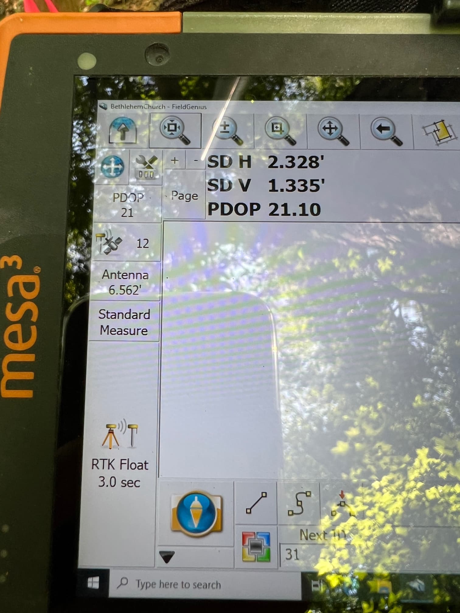
See the attached photo. This point was easily shot with the RS2. The RS2 was fixed tracking 35 SVs and shows a 0.03 RMS in raw data. The photo shows my best effort on the same point with the Bad Elf unit using the RS2 base and Emlid caster. I have not traversed to this one yet, but based on the record plat the RS2 position is about 3’ off
I saw this behavior when I initially bought the units and shelved them. I decided to pull them out for another try on a large project. I updated the firmware. Same results using 30 and 31 beta
There is a thread here in the forums about RS2 usage in dense canopies which might be helpful to look at. The RMS value is unfortunately not a good indicator in these conditions.
But as Bryan said: GNSS systems really don’t like the extreme multi-path environment with lots of water to attenuate that forests provide. This is true for all GNSS receivers. Some companies, e.g. Javad, spend quite a lot of effort to squeeze out good data anyway.
You can emulate this to some limited extend with an RS2 as well by traversing the same points twice with at least 30 minutes between each traversal. If the points on both traversals coincide within a few cm/inches there is a high likelihood that it was not a “false fix”, if they differ than there is not much else but to try again a third time.
I agree with Bryan that using the receiver in a wooded area may lead to such results. To avoid this, you can make repeatable measurements on this point and control the PDOP value which is shown in the Status tab of Emlid Flow.
If it’s higher than 3, the geometry of satellites isn’t the best one, and the receiver is placed in harsh conditions affected by multipath. You need to collect such points very carefully or collect the point several times to track possible position outliers. My suggestion sounds similar to @Alexander’s tip below: