


Hi all,
I am moving my first steps in surveying with EMLID RS2 (sorry for any possible mistake). As far as I know, the italian network of GNSS permanent stations (administrative regions of Liguria, Abruzzo, Lazio, Umbria) sends the corrections in a geographic CRS of ETRF2000 (see for example Stazione Permanente GNSS Regione Abruzzo). Once I set NTRIP corrections, I should create a survey project for my station in the same CRS, which is the EPSG? 6705 or 6706? I cannot find them in the CS list of emlid flow. Thank you
Hi Leopoldo,
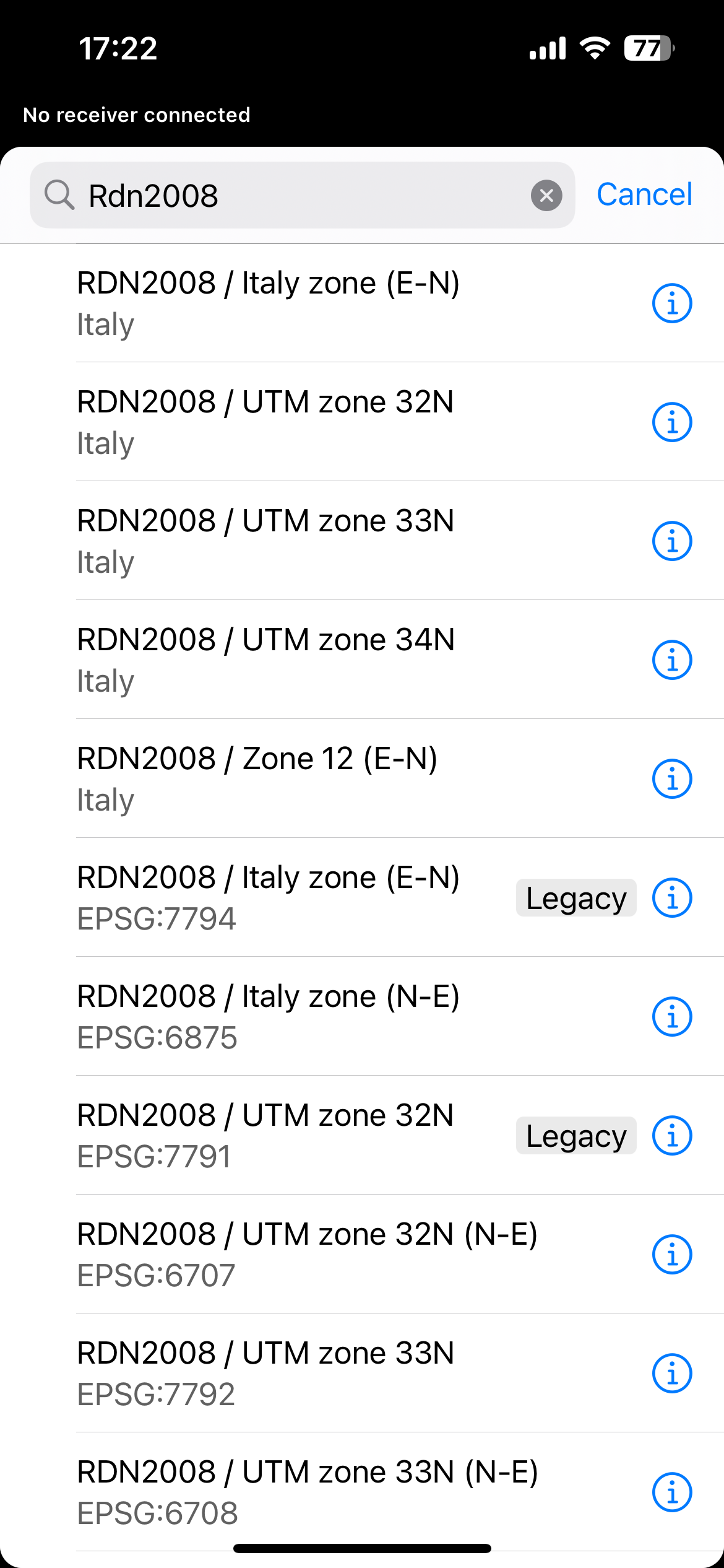
To work with RDN2008 datum, you need to create a project based on it in the Emlid Flow. You can choose the right one depending on the projection you need:
To work with RDN2008 datum in the app, you need to have corrections in it too. However, if I’m not mistaken, RDN2008 and ETRF2000 should be close to each other. But I think the best way to understand it is to do measurements on the benchmarks and check if the results match.
1 Like
Hello Julia, thank you for the reply. I can confirm you that the corrections we receive in many areas of Italy are geographic in EPSG 6706 (with elevation) or projected in EPSG 6708 (without elevation). Is there any user that have successfully used EPSG 6706? I can see that it is absent. How can I add it to the Emlid database? Thank you
To work with geographic coordinate systems in Emlid Flow, we provide Global CS option. With it, your project will be in the same CS as your corrections. So if your corrections are in RDN2008, all the collected points will be in it too.
For EPSG:6708, you can find it using the EPSG code or the CS’s name. It’s part of our old registry, so you can create a project in it using only Emlid Flow. But I’ll note your request to move it to our new registry.

I am sure that we have users from Italy. So yes, it would be great if they shared their experience on this, too.
1 Like
Hi Leopoldo,
We have a coordinate system that is almost identical to the EPSG:6708 in our registry. It’s named RDN2008 / UTM zone 33N in the app. The only difference is that the second one has another axis order (E-N vs N-E). Would it work for you?
RDN2008 / UTM zone 33N corresponds to EPSG:7792.
There is this note that describes the various options (sorry, only in Italian):
Informal Note: The projection is identical to the one in UTM, but the reference frame is different. If you connect to a national correction system, and in Flow you select UTM32 or UTM33, being the correction sent using the RDN reference frame the calculated coordinates are in the RDN reference frame.
Flow expects homologous data frames, and the transformation is identical.
In fact flow warns you about checking the NTRIP server coordinates.
Massimo
This topic was automatically closed 99 days after the last reply. New replies are no longer allowed.