Repeated PSM measurements with different elevations

Hi, I was able to upload and get a result from OPUS for the file (ProntoBase0_20240701125509) uploaded to the forum yesterday.
I arbitrarily set the ARP height to 2.0m after you had mention having a 2m pole and I submitted the file to OPUS “Static”. I also decimated the .240 file using Emlid Studio’s Convert to Rinex option, using the Time Rounding and 30 Interval setting. I also only selected GPS, because that is all the standard OPUS uses.
Below are the results.

OPUS solution : ProntoBase0_raw_20240701125509_OPUS.24O OP1719871607394
opus opus@ngs.noaa.gov
Mon, Jul 1, 5:09 PM (21 hours ago)
FILE: ProntoBase0_raw_20240701125509_OPUS.24O OP1719871607394

2005 NOTE: The IGS precise and IGS rapid orbits were not available
2005 at processing time. The IGS ultra-rapid orbit was/will be used to
2005 process the data.
2005
NGS OPUS SOLUTION REPORT
========================
All computed coordinate accuracies are listed as peak-to-peak values.
For additional information: OPUS: the Online Positioning User Service, process your GNSS data in the National Spatial Reference System

  USER: 				             DATE: July 01, 2024

RINEX FILE: pron183m.24o TIME: 22:09:18 UTC

SOFTWARE: page5 2008.25 master291.pl 160321 START: 2024/07/01 12:56:00
EPHEMERIS: igu23211.eph [ultra-rapid] STOP: 2024/07/01 15:53:00
NAV FILE: brdc1830.24n OBS USED: 4045 / 4521 : 89%
ANT NAME: EML_REACH_RS2+ NONE # FIXED AMB: 24 / 34 : 71%
ARP HEIGHT: 2.000 OVERALL RMS: 0.018(m)

REF FRAME: NAD_83(2011)(EPOCH:2010.0000) ITRF2014 (EPOCH:2024.4989)

     X:      -544018.078(m)   0.142(m)           -544018.973(m)   0.142(m)
     Y:     -5503240.960(m)   0.137(m)          -5503239.489(m)   0.137(m)
     Z:      3167268.592(m)   0.048(m)           3167268.383(m)   0.048(m)

   LAT:   29 58  3.30812      0.028(m)        29 58  3.32458      0.028(m)
 E LON:  264 21 15.90440      0.154(m)       264 21 15.86578      0.154(m)
 W LON:   95 38 44.09560      0.154(m)        95 38 44.13422      0.154(m)
EL HGT:           14.361(m)   0.131(m)                13.065(m)   0.131(m)

ORTHO HGT: 41.910(m) 0.167(m) [NAVD88 (Computed using GEOID18)]

                    UTM COORDINATES    STATE PLANE COORDINATES
                     UTM (Zone 15)         SPC (4204 TXSC)

Northing (Y) [meters] 3318138.952 4241178.496
Easting (X) [meters] 244711.068 923691.456
Convergence [degrees] -1.32221111 1.64337222
Point Scale 1.00040416 0.99992404
Combined Factor 1.00040190 0.99992178

US NATIONAL GRID DESIGNATOR: 15RTP4471118139(NAD 83)

                          BASE STATIONS USED

PID DESIGNATION LATITUDE LONGITUDE DISTANCE(m)
DE5999 ADKS ADDICKS 1795 CORS ARP N294727.473 W0953511.041 20396.2
DH3608 TXHE HEMPSTEAD CORS ARP N300556.472 W0960348.544 42861.0
AF9521 LKHU LAKE HOUSTON CORS ARP N295448.440 W0950844.688 48627.6

             NEAREST NGS PUBLISHED CONTROL POINT

AW5522 N 1502 N295905.660 W0953925.700 2220.4

This position and the above vector components were computed without any
knowledge by the National Geodetic Survey regarding the equipment or
field operating procedures used.

2 Likes

I’d like to see the baseline residuals. You can see these if you select the “extended” output. The baseline residuals are the baselines to the surrounding CORS used in the computation. This would be a true indication of the error of your computed point. Nevertheless, the accuracy of the 3 hour static observation is not very good in my opinion. I suspect there is multipath at this station.

2 Likes

Up against trees and building?

2 Likes

Once the OP gets the hang of it… don’t use such a short amount of time or rapid-static, use 7-8 hours.

Sounds like just testing and playing until figured out. You’ll get it figured out eventually, especially being here at Emlid. :stuck_out_tongue_winking_eye:

1 Like

This CORS is doing double-doodie as an outhouse :poop:

https://geodesy.noaa.gov/CORS/sitephotos.shtml?site=adks

https://www.ngs.noaa.gov/cgi-bin/ds_mark.prl?PidBox=DE5999

1 Like

LOL…he said doodie

1 Like

timd1971, I see you have a 2024 pic. We lost the trees immediately around the station on May 16th in the last storms.

In any case, the base has a constant fix, so I thought the placement was good enough. The rest of that yard is subject to movement tho.

1 Like

Only now sorry, had to focus on some things here.

As was pointed out above you now have all frequencies and constellations appearing in the file so all appears normal…now. It’s got me stumped how you managed to clobber everything else previously. In a Trimble base you can wantonly unpluck any frequency that doesn’t get your fancy but I can’t see how you could disable frequencies in Flow/Reach, or an Emlid Studio Convert to Rinex function.

Did you do anything different this time, or run it through a another RINEX converter with unnatural settings?

Your latest RINEX file is “good” in so far as it has all the right detail…but that detail further confirms it’s not so good in other ways.

I ran it through AUSPOS here with no problem, but the result is similar to all the other results above in that it has higher than expected uncertainty. Relevant extract here:

And delving deeper into the RINEX file you can see why in the plots, there’s a lot of noise and multipath all the way up to an elevation of 30 degrees’ish above the horizon that’s messing with your results:

So the guys are on the right track, even though it’s a different location this time, a quick Google Earth peek at both is similar…your equipment is a perpetual tree & building magnet. Even passing trucks on your road bridge could be causing you grief.

Try to get away into an open area as far from any blocking/reflecting obstacles as you can. Ideally you want to have clear view of the sky all around above 15 degrees. Trees are bad, the buildings worse. Any signals that reflect off something travel a longer distance to get to the receiver and that messes up the calculations. That’s the multipath.

If you can’t get completely clear you could also try experimenting with adjusting your elevation mask a bit higher to tell the Reach to ignore the lower elevation noisy rubbish raining out of the tress or bouncing off or being blocked by the buildings that it can’t see from polluting your results.

But whatever you do you need to start shifting from where you are currently squatting.

3 Likes

Not necessarily so, this could equally mean you are in a very wrong position depending on the conditions mentioned above.

In a bad environment a fix solution can be worse than float as the multipath can cause errors in the calculations jump by increments of whole fixed wavelengths.

The Reach is like a kid on social media, it believes everything it’s told and it’s up to you to help it. It can’t see the trees, buildings and vehicles sending the signals for laps around the house that you can and it assumes all the signals it receives are legitimate and direct. Look after it and guide it to a safe place and it will look after you.

3 Likes

I resubmitted to OPUS and selected the extended option.
Below are the results.

OPUS solution : ProntoBase0_raw_20240701125509_OPUS.24O OP1720013446176
opus opus@ngs.noaa.gov
8:32 AM (3 minutes ago)

FILE: ProntoBase0_raw_20240701125509_OPUS.24O OP1720013446176

                          NGS OPUS SOLUTION REPORT
                          ========================

All computed coordinate accuracies are listed as peak-to-peak values.
For additional information: OPUS: the Online Positioning User Service, process your GNSS data in the National Spatial Reference System

  USER: 			                     DATE: July 03, 2024

RINEX FILE: pron183m.24o TIME: 13:31:27 UTC

SOFTWARE: page5 2008.25 master252.pl 160321 START: 2024/07/01 12:56:00
EPHEMERIS: igu23211.eph [ultra-rapid] STOP: 2024/07/01 15:53:00
NAV FILE: brdc1830.24n OBS USED: 4143 / 4521 : 92%
ANT NAME: EML_REACH_RS2+ NONE # FIXED AMB: 27 / 39 : 69%
ARP HEIGHT: 2.000 OVERALL RMS: 0.018(m)

REF FRAME: NAD_83(2011)(EPOCH:2010.0000) ITRF2014 (EPOCH:2024.4989)

     X:      -544018.040(m)   0.028(m)           -544018.935(m)   0.028(m)
     Y:     -5503240.975(m)   0.090(m)          -5503239.504(m)   0.090(m)
     Z:      3167268.585(m)   0.071(m)           3167268.376(m)   0.071(m)

   LAT:   29 58  3.30776      0.017(m)        29 58  3.32422      0.017(m)
 E LON:  264 21 15.90588      0.037(m)       264 21 15.86725      0.037(m)
 W LON:   95 38 44.09412      0.037(m)        95 38 44.13275      0.037(m)
EL HGT:           14.367(m)   0.112(m)                13.071(m)   0.112(m)

ORTHO HGT: 41.916(m) 0.147(m) [NAVD88 (Computed using GEOID18)]

                    UTM COORDINATES    STATE PLANE COORDINATES
                     UTM (Zone 15)         SPC (4204 TXSC)

Northing (Y) [meters] 3318138.940 4241178.486
Easting (X) [meters] 244711.107 923691.496
Convergence [degrees] -1.32221111 1.64337222
Point Scale 1.00040416 0.99992404
Combined Factor 1.00040190 0.99992178

US NATIONAL GRID DESIGNATOR: 15RTP4471118139(NAD 83)

                          BASE STATIONS USED

PID DESIGNATION LATITUDE LONGITUDE DISTANCE(m)
ADKS 20396.2
TXHE 42861.0
ZHU1 30329.9

             NEAREST NGS PUBLISHED CONTROL POINT

Information on nearest mark is not available due to database connectivity issues or
has restrictions on when or how it can be published.

                      BASE STATION INFORMATION

STATION NAME: adks a 10 (Addicks 1795 CORS ARP; Houston, Texas, U.S.A.)
MONUMENT: 49446M001
XYZ -539282.7280 -5513496.7500 3150287.1900 MON @ 2010.0000 (M)
XYZ -0.0146 -0.0008 -0.0030 VEL (M/YR)
NEU 0.0000 0.0000 0.0000 MON TO ARP (M)
NEU 0.0006 0.0014 0.0893 ARP TO L1 PHASE CENTER (M)
NEU -0.0002 0.0000 0.1178 ARP TO L2 PHASE CENTER (M)
XYZ -0.2121 -0.0120 -0.0439 VEL TIMES 14.4989 YRS
XYZ 0.0000 0.0000 0.0000 MON TO ARP
XYZ -0.0062 -0.0770 0.0450 ARP TO L1 PHASE CENTER
XYZ -539282.9462 -5513496.8389 3150287.1911 L1 PHS CEN @ 2024.4989
XYZ 0.0000 -0.0000 -0.0000 + XYZ ADJUSTMENTS
XYZ -539282.9462 -5513496.8389 3150287.1911 NEW L1 PHS CEN @ 2024.4989
XYZ -539282.9401 -5513496.7620 3150287.1461 NEW ARP @ 2024.4989
XYZ -539282.9401 -5513496.7620 3150287.1461 NEW MON @ 2024.4989
LLH 29 47 27.48884 264 24 48.91866 2.8304 NEW L1 PHS CEN @ 2024.4989
LLH 29 47 27.48882 264 24 48.91861 2.7411 NEW ARP @ 2024.4989
LLH 29 47 27.48882 264 24 48.91861 2.7411 NEW MON @ 2024.4989

STATION NAME: txhe a 8 (Hempstead; Hempstead, Texas, U.S.A.)
MONUMENT: NO DOMES NUMBER
XYZ -583376.2370 -5491903.3420 3179899.4000 MON @ 2010.0000 (M)
XYZ -0.0130 0.0074 -0.0048 VEL (M/YR)
NEU 0.0000 0.0000 0.0000 MON TO ARP (M)
NEU 0.0002 0.0001 0.0660 ARP TO L1 PHASE CENTER (M)
NEU 0.0003 0.0002 0.0580 ARP TO L2 PHASE CENTER (M)
XYZ -0.1879 0.1067 -0.0692 VEL TIMES 14.4989 YRS
XYZ 0.0000 0.0000 0.0000 MON TO ARP
XYZ -0.0059 -0.0567 0.0332 ARP TO L1 PHASE CENTER
XYZ -583376.4308 -5491903.2920 3179899.3640 L1 PHS CEN @ 2024.4989
XYZ -0.0000 -0.0000 -0.0000 + XYZ ADJUSTMENTS
XYZ -583376.4308 -5491903.2920 3179899.3640 NEW L1 PHS CEN @ 2024.4989
XYZ -583376.4249 -5491903.2353 3179899.3308 NEW ARP @ 2024.4989
XYZ -583376.4249 -5491903.2353 3179899.3308 NEW MON @ 2024.4989
LLH 30 5 56.48940 263 56 11.41527 47.4954 NEW L1 PHS CEN @ 2024.4989
LLH 30 5 56.48940 263 56 11.41526 47.4294 NEW ARP @ 2024.4989
LLH 30 5 56.48940 263 56 11.41526 47.4294 NEW MON @ 2024.4989

STATION NAME: zhu1 a 5 (Houston WAAS 1; Houston, Texas, U.S.A.)
MONUMENT: NO DOMES NUMBER
XYZ -513864.3898 -5506451.3480 3166720.2752 MON @ 2010.0000 (M)
XYZ -0.0119 0.0084 -0.0060 VEL (M/YR)
NEU 0.0000 0.0000 0.0000 MON TO ARP (M)
NEU 0.0009 -0.0040 0.4444 ARP TO L1 PHASE CENTER (M)
NEU -0.0011 -0.0011 0.4571 ARP TO L2 PHASE CENTER (M)
XYZ -0.1719 0.1223 -0.0873 VEL TIMES 14.4989 YRS
XYZ 0.0000 0.0000 0.0000 MON TO ARP
XYZ -0.0397 -0.3826 0.2227 ARP TO L1 PHASE CENTER
XYZ -513864.6015 -5506451.6083 3166720.4106 L1 PHS CEN @ 2024.4989
XYZ 0.0000 0.0000 -0.0000 + XYZ ADJUSTMENTS
XYZ -513864.6015 -5506451.6083 3166720.4106 NEW L1 PHS CEN @ 2024.4989
XYZ 29.0000 57.0000 42.8265 NEW ARP @ 0.0000
XYZ 29.0000 57.0000 42.8265 NEW MON @ 0.0000
LLH 0 0 0.00000 0 0 0.00000 0.0000 NEW L1 PHS CEN @ 0.0000
LLH 0 0 0.00000 0 0 0.00000 0.0000 NEW ARP @ 0.0000
LLH 0 0 0.00000 0 0 0.00000 0.0000 NEW MON @ 0.0000

                     REMOTE STATION INFORMATION

STATION NAME: pron 1
MONUMENT: NO DOMES NUMBER
XYZ -544018.9491 -5503240.2236 3167268.9756 MON @ 2024.4987 (M)
NEU 0.0010 -0.0019 2.0000 MON TO ARP (M)
NEU -0.0010 0.0019 0.1349 ARP TO L1 PHASE CENTER (M)
NEU -0.0004 -0.0001 0.1371 ARP TO L2 PHASE CENTER (M)
XYZ -0.1723 -1.7235 0.9999 MON TO ARP
XYZ -0.0096 -0.1170 0.0665 ARP TO L1 PHASE CENTER
XYZ -544019.1310 -5503242.0641 3167270.0420 L1 PHS CEN @ 2024.4989

BASELINE NAME: adks pron
XYZ 0.0275 0.6924 -0.5845 + XYZ ADJUSTMENTS
XYZ -544019.1036 -5503241.3717 3167269.4575 NEW L1 PHS CEN @ 2024.4989
XYZ -544019.0939 -5503241.2547 3167269.3909 NEW ARP @ 2024.4989
XYZ -544018.9216 -5503239.5312 3167268.3911 NEW MON @ 2024.4989
LLH 29 58 3.32421 264 21 15.86785 15.2357 NEW L1 PHS CEN @ 2024.4989
LLH 29 58 3.32424 264 21 15.86777 15.1008 NEW ARP @ 2024.4989
LLH 29 58 3.32421 264 21 15.86785 13.1008 NEW MON @ 2024.4989

BASELINE NAME: txhe pron
XYZ 0.0145 0.6877 -0.5722 + XYZ ADJUSTMENTS
XYZ -544019.1165 -5503241.3764 3167269.4698 NEW L1 PHS CEN @ 2024.4989
XYZ -544019.1069 -5503241.2594 3167269.4032 NEW ARP @ 2024.4989
XYZ -544018.9346 -5503239.5359 3167268.4034 NEW MON @ 2024.4989
LLH 29 58 3.32445 264 21 15.86738 15.2470 NEW L1 PHS CEN @ 2024.4989
LLH 29 58 3.32449 264 21 15.86731 15.1121 NEW ARP @ 2024.4989
LLH 29 58 3.32445 264 21 15.86738 13.1121 NEW MON @ 2024.4989

BASELINE NAME: zhu1 pron
XYZ -0.0007 0.7782 -0.6431 + XYZ ADJUSTMENTS
XYZ -544019.1318 -5503241.2859 3167269.3989 NEW L1 PHS CEN @ 2024.4989
XYZ -544019.1221 -5503241.1690 3167269.3323 NEW ARP @ 2024.4989
XYZ -544018.9498 -5503239.4454 3167268.3325 NEW MON @ 2024.4989
LLH 29 58 3.32389 264 21 15.86648 15.1349 NEW L1 PHS CEN @ 2024.4989
LLH 29 58 3.32393 264 21 15.86641 15.0000 NEW ARP @ 2024.4989
LLH 29 58 3.32389 264 21 15.86648 13.0000 NEW MON @ 2024.4989

                               G-FILES

Axx2024 7 1 24 7 1
B2024 7 11255 24 7 11552 1 page5 v2008.25IGS 137 1 2 27NGS 2024 7 3IFDDPF
IIGS20_2317 IGS 20240602
C00090002 47359816 13 -102572307 52 -169812450 47 X1834APRONX1834AADKS
D 1 2 6053282 1 3 -8140319 2 3 -8318727

Axx2024 7 1 24 7 1
B2024 7 11255 24 7 11552 1 page5 v2008.25IGS 137 1 2 27NGS 2024 7 3IFDDPF
IIGS20_2317 IGS 20240602
C00090001 -393574904 20 113363006 61 126309274 41 X1834APRONX1834ATXHE
D 1 2 3974893 1 3 -6228583 2 3 -9133445

Axx2024 7 1 24 7 1
B2024 7 11255 24 7 11552 1 page5 v2008.25IGS 137 1 2 27NGS 2024 7 3IFDDPF
IIGS20_2317 IGS 20240602
C00090004 301543881 22 -32117803 66 -5481446 40 X1834APRONX1834AZHU1
D 1 2 -2607883 1 3 2919025 2 3 -9028768

               POST-FIT RMS BY SATELLITE VS. BASELINE

        OVERALL     03     05     06     11     12     14     17     19

adks-pron| 0.017 0.026 0.017 0.015 … 0.016 0.020 0.019 …
20 22 24 25 29
adks-pron| … … 0.019 0.017 …

        OVERALL     03     05     06     11     12     14     17     19

txhe-pron| 0.019 0.015 0.023 0.016 … 0.018 0.022 0.020 …
20 22 24 25 29
txhe-pron| … … 0.020 0.019 …

        OVERALL     03     05     06     11     12     14     17     19

zhu1-pron| 0.018 0.020 0.016 0.016 … 0.019 0.020 0.020 …
20 22 24 25 29
zhu1-pron| … … 0.020 0.018 …

                    OBS BY SATELLITE VS. BASELINE

        OVERALL     03     05     06     11     12     14     17     19

adks-pron| 1380 17 89 337 … 267 149 230 …
20 22 24 25 29
adks-pron| … … 141 150 …
OVERALL 03 05 06 11 12 14 17 19
txhe-pron| 1416 9 87 326 … 308 151 233 …
20 22 24 25 29
txhe-pron| … … 149 153 …
OVERALL 03 05 06 11 12 14 17 19
zhu1-pron| 1347 26 73 313 … 280 122 238 …
20 22 24 25 29
zhu1-pron| … … 144 151 …

ITRF position of pron as determined by individual baselines
X Y Z
adks -544018.922 -5503239.531 3167268.391
txhe -544018.935 -5503239.536 3167268.403
zhu1 -544018.950 -5503239.445 3167268.333

Residuals of position determined by individual baselines from the final position
X Y Z East North Up
adks 0.014 -0.027 0.015 0.016 0.001 0.030
txhe 0.001 -0.032 0.028 0.004 0.008 0.041
zhu1 -0.014 0.059 -0.043 -0.020 -0.009 -0.071

Covariance Matrix for the xyz OPUS Position (meters^2).
0.0000015844 0.0000002574 -0.0000002454
0.0000002574 0.0000251667 -0.0000017303
-0.0000002454 -0.0000017303 0.0000153667

Covariance Matrix for the enu OPUS Position (meters^2).
0.0000017623 -0.0000010861 0.0000017476
-0.0000010861 0.0000162374 -0.0000032663
0.0000017476 -0.0000032663 0.0000241182

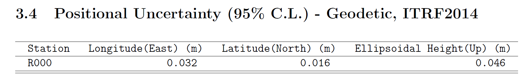
Horizontal network accuracy = 0.00802 meters.
Vertical network accuracy = 0.00963 meters.

                   Derivation of NAD 83 vector components

Position of reference station ARP in NAD_83(2011)(EPOCH:2010.0000).
Xa(m) Ya(m) Za(m)
ADKS 0.00000 0.00000 0.00000
TXHE 0.00000 0.00000 0.00000
ZHU1 0.00000 0.00000 0.00000

Position of reference station monument in NAD_83(2011)(EPOCH:2010.0000).
Xr(m) Yr(m) Zr(m)
ADKS 0.00000 0.00000 0.00000
TXHE 0.00000 0.00000 0.00000
ZHU1 0.00000 0.00000 0.00000

Velocity of reference station monument in NAD_83(2011)(EPOCH:2010.0000).
Vx (m/yr) Vy (m/yr) Vz (m/yr)
ADKS -0.00083 -0.00012 -0.00090
TXHE 0.00088 0.00808 -0.00255
ZHU1 0.00193 0.00909 -0.00400

Vectors from unknown station monument to reference station monument
in NAD_83(2011)(EPOCH:2010.0000).
Xr-X= DX(m) Yr-Y= DY(m) Zr-Z= DZ(m)
ADKS 544018.04000 5503240.97500 -3167268.58500
TXHE 544018.04000 5503240.97500 -3167268.58500
ZHU1 544018.04000 5503240.97500 -3167268.58500

   STATE PLANE COORDINATES - U.S. Survey Foot
     SPC (4204    TXSC)

Northing (Y) [feet] 13914599.749
Easting (X) [feet] 3030477.850
Convergence [degrees] 1.64337222
Point Scale 0.99992404
Combined Factor 0.99992178

          ********** New Reference Frame Preview **********

We are replacing the nation’s NAD 83 and NAVD 88 datums, to improve access and accuracy of
the National Spatial Reference System. More at https://geodesy.noaa.gov/datums/newdatums/

Below are approximate coordinates for this solution in the new frames:

APPROX ORTHO HGT: 41.702 (m) [PROTOTYPE (Computed using xGeoid19B,GRS80,ITRF2014)]

This position and the above vector components were computed without any
knowledge by the National Geodetic Survey regarding the equipment or
field operating procedures used.

1 Like

All the baseline residuals should be <2 cm . I constantly get sub centimeter if logging for more than an hour. In some cases <30 minutes.

It all depends on your observation site. With any GNSS receiver, multipath is not a good thing. Some high $$ receivers like our Javad equipment are good at mitigating multipath, others not.

As @Wombo said, any kind of building, trees near your observation point will affect your computed point.

2 Likes

The NEW datums are going to be fun :face_with_spiral_eyes:

2 Likes

Yeah, I saw that also. Yes, it should be “fun”
especially when on half the maps, they don’t disclosed what they have used…

1 Like

https://www.ngs.noaa.gov/corbin/class_description/Reducing_Error_Sources/

2 Likes

I see that @mark1st.john has entered the 2M pole height for the OP’s ARP (mark up to Bottom of Antenna Mount (BAM) which is correct. (OP is using 2M pole).

So I also assume the Antenna used which is selected correctly as: EML_REACH_RS2+ NONE

  1. Does OPUS automatically pull the Antenna Phase Center offset from the calibration file information in order to account for the APC and add to the ARP???
    L1 134.92mm
    L2 137.10mm

So obviously just use the ARP of 2M pole height, do not add the APC of L1 134.92mm from calibration data (or Emlid’s provided 134mm?). JUST ARP.

  1. I notice in the OP’s RINEX .24O Observation files that the Antenna Height is 0.
    This tells me the OP has NOT entered the ARP Height (2M pole) in the LOG SETTINGS?
    Shouldn’t the ARP be entered here before logging? And if so, will the RS2+ APC be added to it when the RINEX files saved? So then the resulting RINEX .24O file would show Antenna Height as 2.1392M?) (2.134M?) Or just 2M?

  2. Should number 2 also apply for the Height setting in Emlid Studio?

Did not know this:

2 Likes

AUSPOS is similar, you have to click “Scan” to tell it to read the antenna model and any height from the RINXEX file. Or you can manually enter them (or override whatever was scanned) before submitting.
Either way it then applies the appropriate ARP offset from it’s IGS antenna file.
If you chose antenna type “Default” it would ignore ARP offset and provide APC.

3 Likes

Thank you @Wombo. I will have to try it and the other PPP sites too.

My issue is also I use non-Emlid antennas such as a TOP106 (from calibration data file: L1: 52.04mm, L2: 48.05mm) with M2. So instead of that “don’t have to think about it” part when using Emlid built-in antenna receivers with Flow and Studio, leaves open uncertainty of course with the proper offsets taken into account. The diagram when selecting M2 shows to use MEASURE TO which appears to be the ARP to mark. (fyi, not using the Emlid helical antenna).

Agreed. Per a recent conversation I had with people at NGS (1 July 2024), OPUS (GPS) and BETA OPUS (GPS, GLONASS, and Galileo) ignore the RINEX header and use only the antenna values provided by the user via the upload page. I can also relay that selecting the appropriate antenna type accounts for the APC to ARP difference and applies the appropriate antenna calibration model.

3 Likes