I’ve been asked to document shoreline for an environmental project. The scope does not require that I reference a vertical datum, but the project information does use the MLLW tidal datum and I always like to provide as much as I can within my capability.
There are not that many published benchmarks referencing MLLW, and the closest one is on a US Naval submarine base, so I probably cannot access that.
Is there anyone on here with knowledge about how I could go about referencing MLLW for my photogrammetry outputs?
First - thank you Bryan for mentioning Dave’s post!
If I understand correctly Dave, it sounds to me that they are asking for a referenced vertical datum, i.e., the mean lower low water TIDAL datum, but that they aren’t asking for a referenced TERRESTRIAL vertical datum. Please affirm or correct this understanding.
VDatum is a wonderful program for anybody working in waters along the coast of the U.S. It’s also a mature tool that’s been under development since about 2006 but the transformation grids for Maine didn’t get here until about 2011. Its origins are very much related to tidal levels, but its functions include a great coordinate transformation tool so inland surveyors can also benefit from VDatum. I remember following its development with great interest for several years and was very excited when our area, the last area, got the grids. These grids are essentially correlations between tidal and terrestrial datums. There’s tons written about it and can explain it better. I encourage you to study the bits on uncertainty:
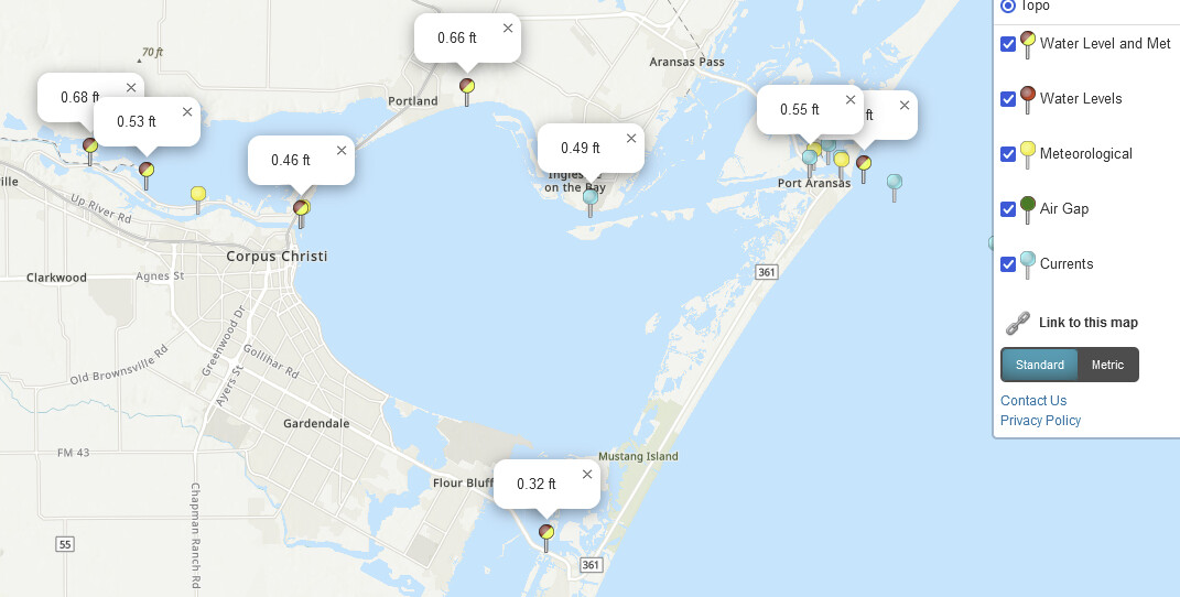
I would also encourage you to contact the USN base in Corpus Christi and request permission to perform your survey if that’s where you’re referring.
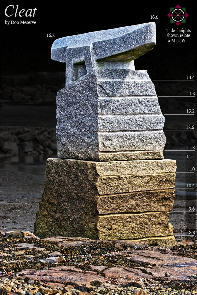
Photo date: 20110823
MLLW values shown on the horizontal marks of Don’s sculpture located in Winter Harbor, Maine were determined by a surveyed terrestrial NAVD88 value using VDatum. Nerdvana
VDatum was really a milestone because since the late 1980s, the early regulatory language from Maine DEP concerning building setbacks was chocked full of vagaries and subjective determinations like: the point from which we’re to begin measuring the setback was where predominantly salt tolerant vegetation stopped. Even though we now had the science, and the tools, it took MDEP several years before was reflected in their regulatory language. The last hurdle cleared being the recognition of the highest astronomic tide for the entire current NTDE.
Thanks Kelly for the info. It explains a lot for me and I hope for Dave.
I’m wondering if a new point can be established and referenced to a local passive H/V benchmark based on NAVD88 at the site and then use VDATUM for the conversion.
I’ve uised it a couple of times converting old NGVD29 to NAVD88 heights, however it’s not very accurate. I may have used another NGS program before VDATUM, that’s how long it’s been.
Thank you for pointing out the vDatum tool. I suspect this will be sufficient. My contact is looking into whether or not a local benchmark has been established on site.
I’m in Washington state and the Navy submarine base is Bangor.
My bad, sorry. For some reason I thought that you were in Texas.
One other thing that may interest you is the section of my article concerning repeated RTK heights, Emlid Flow, and using the RS2+ as base and rover which you’re welcome to examine:
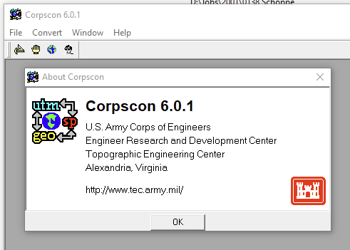
Yep, it was CORPSCON. In fact I have it on my old W7 workstation. The last time I can remember using it was about 4-5 years ago. I really liked it, I imported the GEOID12B into the software and it worked great. There was an issue with the scale factor for some reason as I remember USACE putting a notice out. I never had any issues with it.
Thanks for reminding me Kelly, I’m going to try and install on my W11 machine even though the software is old.
I’m not sure, but believe that the U.S. Army Corps of Engineers no longer supporting this and I couldn’t find it on their website this morning. The latest version I’m aware of is version 6.1
VDatum is much, much better and is one reason why I stopped using it years ago.
NGS’s NCAT is another tool to consider, however its height options are quite limited compared to VDAtum
Yep, I got a copy of Corpscon. Yes, they stopped supporting years ago. I ve used vertcon and it’s superior but I wish ncat would hurry up the vertical issue. It’s a good online converter.