


This is the system that I collected gcps in. My client is telling me it is off 1 to 2 meters. Investigating the espg code and I can’t find it. Can someone help?
This is the system that I collected gcps in. My client is telling me it is off 1 to 2 meters. Investigating the espg code and I can’t find it. Can someone help?
Have you tried 6492 for NAD83 (2011)?
Issue is that I was trying to convert it in Geographic Calculator and I couldn’t find it. Running the address through epsg.io, it told me that it should be epsg 4326. I was thinking it may have been collected using an incorrect system and I would convert it. If I couldn’t find the original one, I don’t know how I would convert it.
4326 is WGS84. Can you bring it into QGIS or another program and transform it?
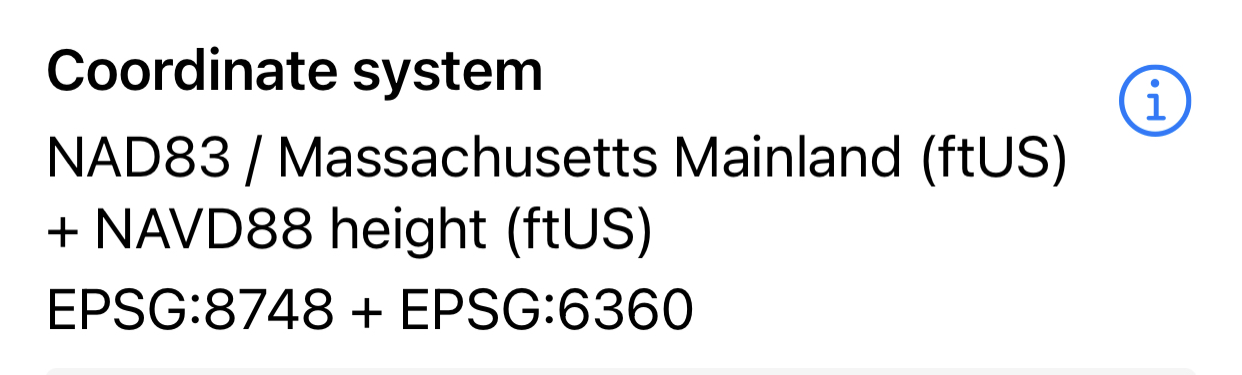
I really want it in Massachusetts state plane which I thought I what the above screenshot was?
The other two projects that I shot and used state plane worked perfectly. This is the only one that is giving my client issues.
The east coast is weird about SP systems. Many still use old codes and others still use HARN. The code I put down is the most common configuration I see. What program is it not coming in correctly in?
I’ll get back to you on that. Need to ask the client.
Could it be an issue with conversion ?
Many of the surveyors in SC not familiar with the NSRS don’t know the difference between ifeet (international foot) vs US survey foot
That’s a good question. Something did pop in my mind. They mentioned that they converted it to WGS84 UTM 18n, when it was to be 19n for the location. I’m hoping it’s that simple that they converted the wrong UTM.
You might want to ask what software they are using maybe ? NGS converters are all I use… they have new converter now.
Thanks. COVID put a gap in running projects and I forgot about this website.
Sadly that was just a typo. They were processing it in 19n.
So they are processing it with agisoft.
Can anyone recommend why the epsg code it shows can’t be found?
Disregard, I found it. I don’t know why it didn’t show on epsg.io before, but now it does. I’m at a lose. I don’t know what to do now. It appears that the Massachusetts mainland is correct as I thought and they did process it in 19n. Even before that, when in state plane it is still showing them it is off 1 to 2 meters.
I still don’t understand off 1-2 meters in comparison to what? Horizontally, vertically?
I asked the same. It appears that one of my GCP targets, which had folded in half due to wind, may be apart of the issue. They have disregarded that target and left it in the local projection and will convert to WGS84 19N after processing and it appears to be working as it should.
Nice. Good to hear it is working out. So many rabbit holes to be had!
Hi Seth,
Great to hear that it works now.
Seems picking NAVD88 was apart of the issue. When they chose without that it worked perfectly.