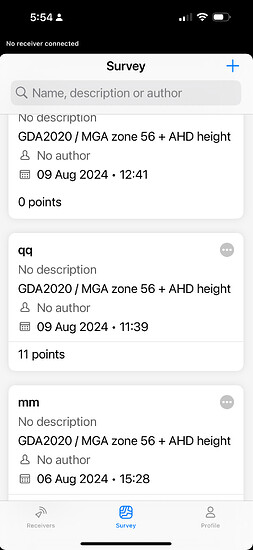
we are also having difficulty for getting updates…we have found that we can only get the system working using a sim…yes we have followed the youtube tutorials to a tee… we are now getting crazy height results v published survey marks… the e/n coords generally ok but the hts vary up to 100-200MM per visit to the same control marks… it is so hard to get support … we are tearing our hair out.
our firmware is ver 10.8 !!!.. have followed all tutorials to update the firmware with no success… yes we have turned on “allow updates via mobile data”…its a shame there is no physical support, someone who can come to our office and get all this sorted out.
Hi @cnorton,
Welcome to our community!
I’ve just reached out to you in private message, as the investigation will require some sensitive information.
31486 check (1).pdf (22.2 KB)
Hi @cnorton,
Thank you for the file!
I’ve checked it and see that the elevations you collected match, but they don’t do so with the published coordinates. Can you please specify the vertical datum for both the collected and the published coordinates? Are they the same?
Yes, same being A.H.D - Australian Height Datum…it was the first thing we checked.
FYI… we got another emlid user to pop in yesterday … we went over to a nearby park away from our office wifi… we removed the sim card from our reach…he instantly connected his mobile (android) to it using hotspot… but could not get ours to connect to hotspot.
for some reason we are the only users we know that have to use a sim card??
with the 3g phase out in Australia , it shouldnt effect the use of a sim card ?? the reach needs to be able to handle 4g , 5g? correct?
If you are getting consistent vertical differences indicates either your correction source base coordinates, and/or your published reference data is inaccurate or incorrect.
The Reach is simply providing a precise differential to whatever you are feeding it.
Reach works fine with any GA Reg 13 coordinated CORS source, and at least here in Victoria, calibrated SMES survey marks. Other states should not be any different.
What state are you in and what are your sources? You need to look there first.
If you are on Telstra or Optus 3G is still operational and will have zip effect. That said unless you had a specific reason to dedicate a SIM it’s generally better to source corrections via the mobile data or WiFi device.
Hi @cnorton,
The collected coordinates match, indicating that Reach operates properly. Did you use your own base for this survey? If so, how did you set it up, using average SINGLE or on a known point?
Speaking of the 3G network shutdown, Reach RS2 has a 3.5G modem, so it doesn’t support 4G/5G SIM cards. They will be able to be used by sharing the Internet from the SIM card via a mobile hotspot further on.
- We are in NSW
- Reach 3 with a SIM card
- Unable to connect to any of our iPhones using hotspot…… hence SIM card
- We had another surveyor visit us (as there is no physical support from mapgear) who has set up multiple units and whilst he connected straight away without the SIM card , he couldn’t connect our iPhone.
- Datum’s and sources are as normal
- We got level variations of 1-200mm on the same marks on different days.
- Because we can’t connect to hotspot we can’t update the firmware / currently ver 10.8
Is the problem
SIM card
Firmware
iPhone
Or the reach 3 unit?
Note: used successfully for last 6 months until recently…… though we have never been able to use it without a SIM card
In relation to Hotspot and iPhones, I found on the iPhone that I had to turn “Maximise Compatibility” on, in Settings > Personal Hotspot.
My understanding is this means the iPhone’s Hotspot now operates in 2.4GHz Mode (instead of 5GHz), which is then compatible with Reach.
It’s still not clear what your “as normal” sources actually are. 200mm variations are certainly not normal but should readily isolated.
If you can share more detail, including also configs and process it would make it easier to provide more specific advice to help you. I would be very surprised if it couldn’t be solved between EMLID’s guide docs & advice here
Are you using NTRIP, and from what source & mountpoint? Is it a GA certificated source? Or are you operating a local base, RTK or PPK? And if so, how was the base control established?
Are your “fluctuating” control marks part of the NSW state PSM network and can you post a datasheet?
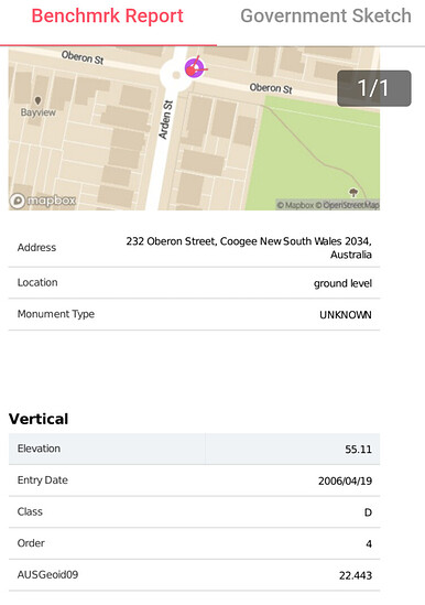
In the absence of your base details I did manage to identify your three control points and they alone are not helping your situation.
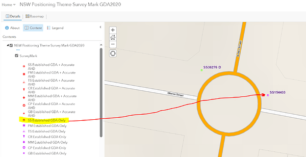
None of the three have accurate AHD verticals, and are considered Class D, 4th order. And at least according to Benchmrk also legacy AusGeoid09 and not the latest AusGeoid2020 which I presume you accepted in the project settings?
This also still needs to verified against whatever your base settings are, but this alone is insufficient to be splitting hairs. Recommend you identify something with established AHD vertical accuracy to do the RS3 testing justice (they are out there, the red ones not purple), and make sure you line the dots up end to end with the base.
Hi @cnorton,
Can you please elaborate on it? As Wombo also underlined, the base configuration and the coordinate system setup are important regarding the obtained coordinates.
Did you use your own base or an NTRIP service? If it was your own, how did you determine its position?
Hi , we have it under control now. Thank you for assisting. The system had been working perfectly for 6 months , then over night the levels went crazy, not the eastings and northing, just the levels.
We deleted the app, reloaded, and upon reload we were able to dload the latest firmware and more importantly, the lates geoid model for AHD.
Hi @cnorton,
Thank you for the update! It’s good to hear that everything’s figured out. If any further questions come up, feel free to leave a comment or create a new thread.
This topic was automatically closed 100 days after the last reply. New replies are no longer allowed.


