Reach RTK for Water Ski and Barefoot Water Ski site setup and surveying

I am involved in both traditional and barefoot water skiing and setting up ski sites these days for record capable tournaments is rather complicated. In particular for traditional or 3 event skiing, the slalom course balls or buoys have to be positioned with high accuracy to create a perfectly aligned record capable homologation level. In the jump event the jump course has to be reasonably accurate (though not as precise as slalom) but there are a number of “grid balls” and video cameras that are used in the jump event with video jump measurement systems such as the Bob Corson, Olaf Boettcher, Felix Loreto and Splasheye systems for distance measurement.

All of these require site surveys in order to verify that they meet all homologation criteria and produce accurate jump measurements.

Barefoot water ski sites are similar in that the barefoot water ski jump measurement requires an accurate course for the boat to drive through and accurate grid balls used to measure the jumps with any of the previously measured video jump measurement systems.

Typically a site survey was at least a two person operation requiring one person operating a total station on shore and one person positioning the reflectors on each ball/buoy out on the water. Positioning the total station so that it has line of sight view of each and every ball in the water can be a challenge. the cost of a total station is high. It can be done with a transit and multiple points but this typically takes 2-3 times longer and measuring that many extra points adds risk of error in measuring or recording.

I am hoping that a pair of Reach RTK units and a mobile device such as a laptop or a tablet can be used instead. This would allow surveying to be done by a single person recording the data points instead of two people and it can also be done in the dark when a ski site is typically not in use and also much calmer as the wind typically dies in the evening.

Surveying on water offers both advantages and disadvantages. One advantage is an excellent sky view. Most sites have an unobstructed view of the satellites. Line of sight communication by radio for RTK correction data is usually easy and radio interference is usually lower in the more rural areas where ski sites are typically located.

I am a year into this project and only part way along due to time constraints but recently I retired from my full time IT position and have been spending more time on this and thought I would write up my work so far in hopes that others can learn from what I have done and contribute suggestions to help me along.

I purchased the Reach RTK units last June and at the time they were pretty new and to be honest, I was having trouble even getting a handle on how I was going to go about this. I also fly drones and was looking into Pixhawk integration and the two combined helped me get to where I am now… which I think is pretty close…

Since I purchased these, the ReachView has matured considerably and a recent addition is the builtin Survey mode that if I am correct in my understanding, this is all I need to make this happen. Thanks Emlid! In addition the ability of the Reach to determine its own position using time average data points greatly simplifies what the operator needs to do to get things set up on site. Initially you had to manually enter base coordinates and they had to be pretty accurate and water skiers are not GIS experts or surveyors generally.

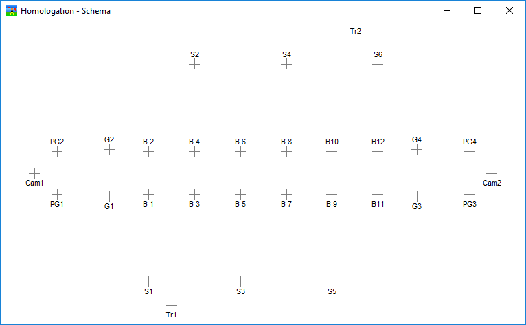
The general scenario is to have a base unit at a fixed known spot at the ski site that communicates the correction information to the rover unit. The rover unit performs the actual survey and is moved from ball to ball to ball out on the water and at each ball a point is recorded and named according the the water ski homologation dossier conventions for each point on the slalom and jump course.

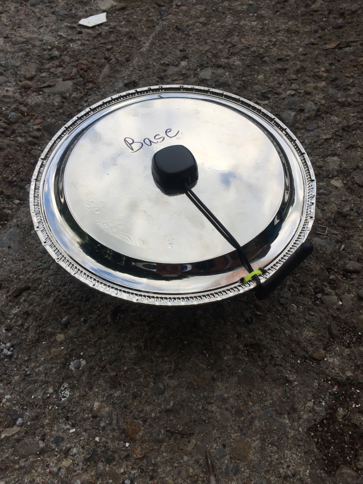
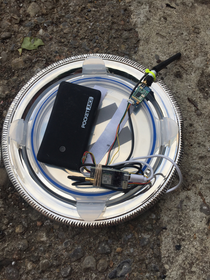
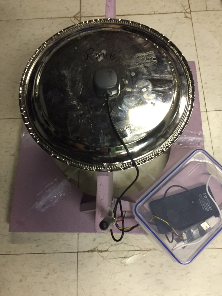
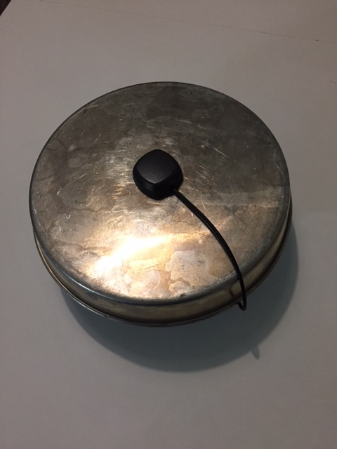
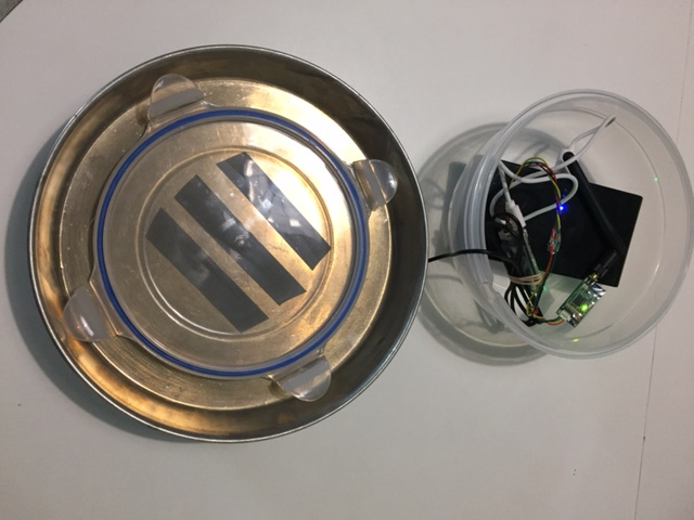
Here are pictures of the two units I have created for the task.

This is the top view of the unit showing the high tech pie pan metal antenna base on top of a household container holding the guts.

This is a picture of the guts of the operating base station.

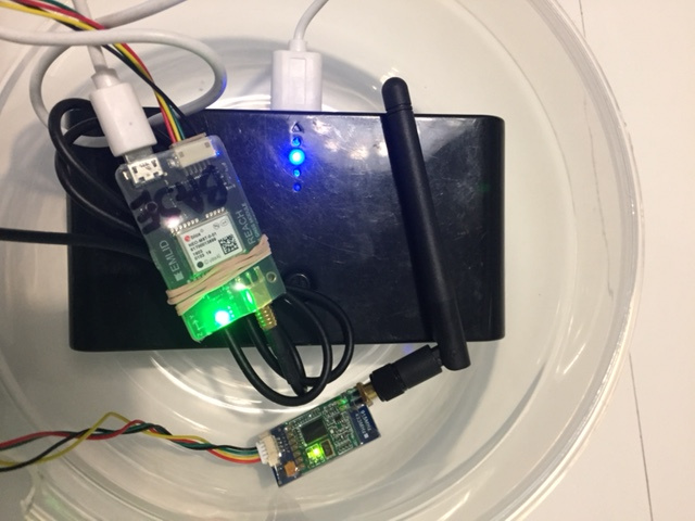
Here is a closer view. You see the Reach unit, the 3DR SIK radio. Power if fron the large black portable battery pack that provides a USB power source to the Reach unit and the radio gets power from the Reach. That battery pack appears to be overkill. Been operating for 8 hours and still going. See the power for the Rover. More appropriate.

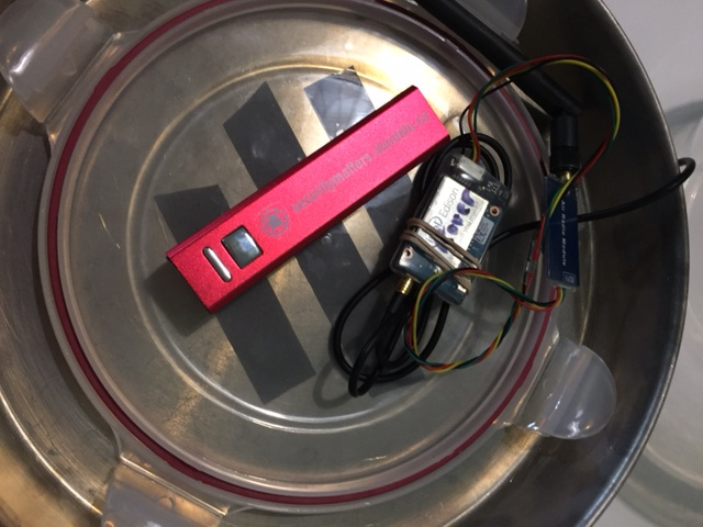
Here is a shot of the Rover unit. This will be placed on a “ring float” that we have already used to hold the survey prism over the ball in the water directly above the top centre of the ball. Notice the smaller red power pack in this one. This is a small portable battery pack that I got free at a trade show for recharging cell phones. This actually powers the unit for about 4 hours on a full charge which is amazing, The unit (including SIK radio) draws under 200 ma in operation!

The first task was getting the Reach units to communicate correction points from base to rover. Since ski sites are up to 1000m long and wifi is a challenge for long range, I opted for radio links for corrections and as I had experience with the 3DR SIK type radios with drones and they have excellent range and communication speed I went that route.

Wiring can be a challenge because there are SO MANY varieties of these 3DR compatible radios so I made a short YouTube video that goes over this and touches on the parameters required in ReachView to get the corrections working.

You can watch the video at Emlid Reach RTK setup - YouTube

At this stage all I have accomplished is getting the base and rover units assembled and done one quick survey on my street where I simply moved the rover along the curb and then exported the survey points into all possible formats to look at. My points were collected manually, not using the survey automatic methods. That will allow me to name them and know which point is which.

The base and rover are unable to connect to any WiFi so they act as WiFi hotspots and it is simply a matter of connecting to the base unit or rover unit WiFi hot spot from an iPad or other mobile device and connecting to 192.168.42.1 in your browser such as Chrome or Safari. Connect to the base first and ensure you have an accurate base location. The default is 2 minutes, I opted for 5 minutes in hopes that it is more acurate. Then connect to the Rover and start a survey and capture data points. When done, export the survey and massage the data.

Where to from here?

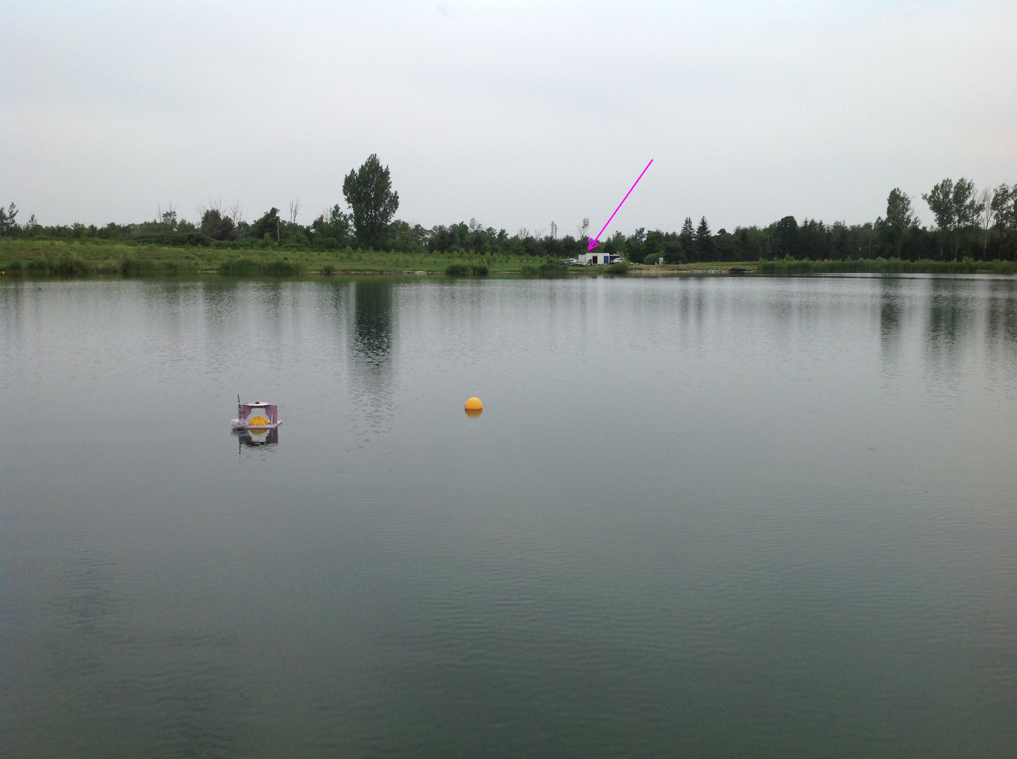
Well, a lake survey will be next… I will try my slalom course first, see how that works out, then survey one that has already been surveyed at a ski site.

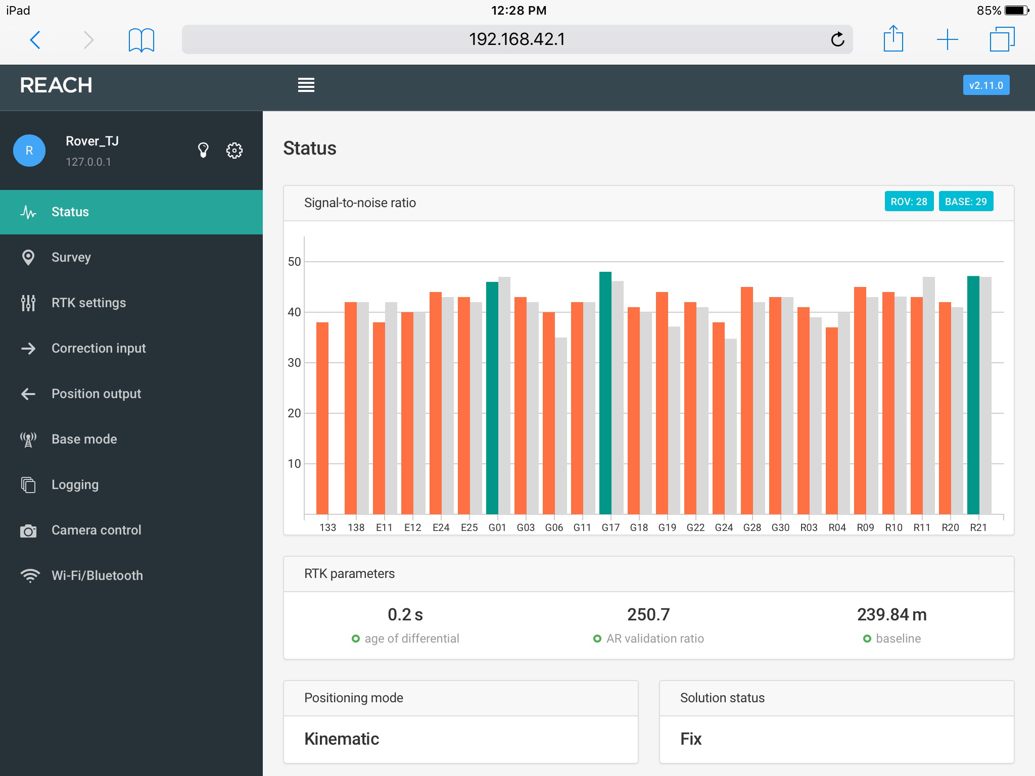
First challenge is that I need cm accuracy for this so I have to ensure that I can get survey points that are better than Float so I need to ensure that only Solution Type FIX points are used. I won’t really know if this is possible until I try at the lake.

Another challenge is taking the points from the survey and translating them into a format that is suitable for the water ski homologation programs that are used. I suspect DXF file may be the easiest to convert but if anyone has suggestions I am open to hear them. The programs typically expect X,Y coordinates or polar coordinates… not lat/long coordinates… this is not my strong area of expertise… Once I have data I will work on figuring out the conversion.

I am also not sure about all the possible parameters. Some are shown in the video. For example, should I disable GLONASS L1observations and use only GPS L1 observations (hints to that in reading some forum posts on not getting FIX Solutions). Should I up the RCTM message rates for these to 5HZ since the 3DR SIK radios are operating at 57600 baud and should have lots of bandwidth for the traffic.

Are there different antennas I can use with the Reach units to get better signals and thus (I assume) better accuracy?

Are my aluminum cake pans sufficient to avoid reflected signals from the water?

Will my wife want her cake pans back?

Is this a finished and working project? No. I am posting hoping for constructive input from others that have more experience than I do at this! I also hope that this inspires others that have been thinking of doing the same or similar and may be willing to contribute their expertise!
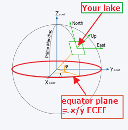
6 Likes

I believe that GLO L1 is OK for use in getting FIX if your Base is same type receiver as the Rover. This would appear to be the case in your setup. Also, you now can add GAL sats which I think helps in faster fixes.

I typically use ENU solution in RTKPOST, but am not sure if you can get it saved in logging. I have not tried it.

There are many contributors here that can answer more questions for you.

Looks like a good job.

Newbie here, I assume that GAL means GALILEO.

So that leads to the next question… WHERE do I have to enable that. I assume in the base unit in the Base mode screen in the RTCM3 messages section, but do I also have to enable GALILEO on both the base and the rover units in the RTK settings screens?

You mention ENU in RTKPOST and all I hear is swish as that goes over my head. I don’t see an ENU option anywhere that I am looking in ReachView… I think you are maybe talking post processing or this is a reference to Kinematic processing | Emlid Studio so I will read up on that before wasting your time.

Thanks for any input you might have…

Just reading through many threads trying to improve my rate of achieving FIX Solution status and saw ivereninov comment in thread Rover get fix solution status very difficult! - #8 by TB_RTK about putting the base on a tripod. Why does this have any effect? I ask because I am using a base in exactly that mode, on the ground. I was under the impression that multipath was a huge issue and so my unit with a cake pan metal plane under the antenna and sitting on the ground should not get any multipath I would think? So what is the advantage of putting the base on a tripod?

Also my rover will be used over water. Identical unit to the base. Metal cake pan as the metal ground plane under antenna. In use it will be on a float about 20cm above the surface of the water where I am surveying.

It looks like you can log file with East-North-Up (meters) (ENU)from Base to Rover. I don’t think ReachView has Real Time output as yet.I think it would be quite useful, but maybe I’m missing something.

Yes, GAL is Galileo. It is quite new, so very much still in testing. Yes, you have to enable GAL in Rover and Base.

PPK (Post processing) has advantage of many more options to adapt to your specific use.

I believe Emlid is adding upgrades to RTKLIB portion of ReachView, so I think best to see upcoming Version(s).

Re Ground versus Tripod: I would think that Tripod gets antenna above obstructions causing multipath. Also, if people,autos, & trucks, etc. pass by. etc. In your case, might not be as much of a problem. Some new improvements in software appear to make this less of a problem in my experience. Not sure if these upgrades are in Real-Time Reach.

Yeah, OK, ENU… really showing my newbie status to this :slight_smile: East North Up.

Since you use RTKPost it sounds like, maybe I am missing something that might make my task easier than say the ReachView survey approach.

So I go out and survey all these slalom course points on the lake and come back with the base logs and the rover logs and RTKPost correlates them all, figures out corrections etc and then gives me corrected coordinates for every log point? How do I figure out which point is which on my survey…

I know I am being thick here and just missing something, but in the survey mode, I place the rover, wait for a FIX solution and tap “add a point” and name the point and capture the point and save the point. More to the point, I set the survey to AUTO collect FIX points after a 2 second FIX status so when I click capture it waits for a FIX then asks if I want to save that one and I say yes.

So how is the log file delineated so that I know which points get associated with which survey position?

I also a newbie in this new SURVEY mode, so others might be able to give you more help. In logs, or RTKPOST/PLOT, you may have to use time to identify points.

As SURVEY mode is a very recent addition, there have been several posts in the FORUM that talk about this just recently.

Have you considered a drone survey of your sites? Water is a real bugbear for the post processing (structure from motion) but the fixed assets, the thing you are interested in are not.

But going back to survey mode and the post processing.

Currently (correct me if I am wrong Emlid) there is no event generated in the raw files from the survey mode so there is no link between the survey mode and anything useful in post processing. You can add a hardware button to the reach that will alow events to be recorded in the raw data stream.

So in survey mode you have to make sure you have a good FIX and then the positions are recorded and can be used straight away. They are generated in Latitude, Longitude and Height.

If you have an Android phone or Tablet there is an excellent piece of software called MapIt (I am not associated with MapIt in any way, I just think it is the missing piece of capability) that can take the Reach bluetooth position and ‘transform’ it to any of the standard grid based measurement/position systems, do position averaging etc. This I think is your answer. It also allows the addition of ‘design’ files so you can see what things should look like, versus what they are like on the ground.

I would be happy to provide you with more information on a one to one basis. simon.allen@spatialanalytics.com.au

1 Like

Thanks for taking the time to read my post and reply. I am going to have a look at MapIt GIS and see if that will help. Also thanks for the offer of assistance… I may need it.

I fly drones and yes I have thought about a drone survey but I am interested in hearing about your thoughts on that. I will email you on that. I assume you are talking a photo survey rather than a GPS survey like I am heading for here. Will email.

Time for a followup post on this thread. I have made some progress since then and actually done a couple of full slalom course surveys at a ski site… now I am working on crunching the data to get it into a format useful for the water ski software I use that needs XY data not GPS data… Working with the author of the software on that.

But I thought I would post a little more on the units and the process as this may help others.

Here are some images of the base and rover units.

The base unit has its guts in a plastic bowl under a pie plate and I set it at some location at the site on shore that has clear sky view.The base is a Reach RTK unit, a 3DR SIK type radio for sending corrections, a portable power bank type USB portable charger that powers the whole thing via USB.


The Rover is the same guts but on a floating affair that you take out on the water and place over each slalom ball which are basically about soccer ball size and anchored half submerged. The cable ties on the float assembly are like springs that keep the ball in the centre for repeat ability.


The survey process is as follows.
Base unit powered on and set in place. It accumulates GPS readings for 10 minutes to determine its location. Once it knows where it is, it starts sending out corrections to the rover via the SIK (3DR) radio.
I take the rover and an iPad out on the water. I connect the ipad to the rover created WiFi and using Safari just connect to 192.168.42.1 and talk to the Reachview on the rover.
In Reachview I create a survey project. I create an auto collect rule for a FIX setting that says accept after 10 seconds. I click + to add a data point.

A water ski course in the water looks like this


The TR1 TR2 CAM1 and CAM2 I am not surveying yet, just the gate balls and skier balls,

In reachview I name the first point PG1, set the rover over the ball at PG1, click Collect and wait for a FIX status.

I have had a few glitches at this point… I get a FIX status, the bar at the bottom counts down my 10 second auto collect rule time and then nothing… It should save it… I ended up having to hit Accept on every one. I have in the past seen it say Save&Go, in fact it ONCE said that on the second survey I did but other times I had to hit Accept after the 10 seconds were up.

The other glitch was at some point I stopped getting a status FIX. Just float. Moved Rover around, back to locations I had previously had a FIX at, nothing, looked at status and had at least 3 green bars… FLOAT… Literally spent 10 minutes at same location, FLOAT… so I rebooted my Rover unit and resumed the survey and was getting FIX status quickly. Hmmm… got nothing on this… Keep in mind this Rover is out floating in a lake with an absolutely clear sky view all around. ZERO obstructions. I sort of expect that every bar would be green and FIX would be near instant… I should say that my first survey I only got FIX for about half the points. Waited a LONG time sometimes (1800 readings for one) and still got FLOAT. Second survey FIX status was near instant for most, then it stopped getting FIX status, then I rebooted and was back to near instant FIX status for the remainder.

After I accept, I name the next point PG2 and move the rover to PG2 and click Collect.

Once done and back on dry land I connect to the ReachView using my laptop and export the project as CSV and start working on making the data compatible with the Waterski Homologation Program.

Thats where I am at right now… Post Processing… The ski program will accept data in many formats mainly from survey instruments. Distance and angle from a single Total Station, or multi station angles, or XY coordinates. XY is where I am heading…

I used XYZwin from NGS/NOAA and converted from LLH to XYZ…

First gripe to Emlid… LLH seems to be Lat Lon Height to everybody in the world except EMlid where its Lon Lat Height. OK pretty minor gripe…

Anyway, I made a bad assumption that since a lake is flat and everything is the same “height” I just ignore that and use X and Y from XYZwin in my waterski software… uh, nope… my projection of the coordinates in XYZ is relative to the equator and by ignoring the Z value I am not projecting it correctly… Emmanuel the author of the waterski program educated me on this with a quick diagram

image

So at this stage I am trying to find a quick utility to convert my GPS points to simple XY coordinates and I am trying to figure out why the Save&Go isn’t happening and why FIX status is sometimes hard to obtain. Did I mention that both base and rover are in completely unobstructed locations.

A couple of things I know I failed to do correctly… In my survey on the rover I can set antenna height and I set it to zero and really I should have set it to .25m which is the height of my rover antenna above water… Hmmm… base antenna height… never even thought about that (out of sight out of mind) and in my survey my base is about 6m above the water… Not sure how big an issue these are given that these are constant.

So thats where I am at.

P.S. Reachview 2.11.0

maybe AutoCAD or SketchUp? or maybe need a data collector and survey software? no idea, just throwing stuff out.

There are two parts here. The survey and then there is export and processing.
The first part would be nice if you had recorded log? It will tell more about your situation.
For export from survey, you could do a batch convert from LLL to UTM coordinates. This will give you XYZ to work with. If you Google search for batch convert LLH to UTM, you’ll find a solution.

Talk about the turning point… HUGE THANKS…
I had XYZ on the brain and the answer was I needed to convert to UTM which gives me the XY that I need for the waterski survey program.

Just spent an hour with the online version of NCAT doing conversions and have my first successful GPS survey entered into the Waterski Homologation Software!!! And all the values look good compared to a traditional total station survey of the same site.

Will have to figure out how to use the NCAT Java batch program for conversion to make that process go easier…

Logs… I have logs form the survey day…
raw_201807141607_UBX.zip
solution_201807141607_LLH.zip
The first is 20MB and the second is 700K

I will need a few pointers on what to look for in the logs…

timd1971 Thx. In the past I played with AutoCAD formats and sketch programs with limited (more like no…) success… thx.

I dont think this forum like uploaded files, could you check the links again?

I think you are correct, no place on the forum for uploaded files like logs.

I have placed the log files on a web site for download:
http://www.tjhs.ca/raw_201807141607_UBX.zip
http://www.tjhs.ca/solution_201807141607_LLH.zip

More than expected if you are willing to look at them…

Excellent, do you have the second raw file for either base or the rover? Not sure which one this file is from.
The solution file is a made ready on the fly from rover, not very good to troubleshooting.

Well that’s a rookie mistake right there! Thanks.

http://www.tjhs.ca/raw_201807141607_UBX.zip base log. (same as previous)

IGNORE THIS… http://www.tjhs.ca/raw_201807142259_UBX.zip Rover log.

http://www.tjhs.ca/raw_201807141625_UBX.zip Rover log from survey time

I was looking at the log directory on the Rover more carefully and I see there were multiple raw_… logs… and the one I posted that I say IGNORE on is from the evening when I was at home with the rover running to gather the survey project I believe…

OK so I am just learning about logs… :slight_smile:

And learning more… there is another log file on the rover that may be needed… base correction sounds important when diagnosing FIX issues? Just a guess.

http://www.tjhs.ca/base_201807141625_RTCM3.zip

1 Like

Thought I might post a couple more pics to give an idea of the environment.
Here is a picture of the rover out in the lake over one of the balls that I am surveying.
The pink arrow points to the top left corner of the steel shipping container where the base unit is located.

Here is a screen shot of my status on the Rover unit. Frankly I am a little surprised that given the location and the clear sky view I am expecting I would have more green bar satellites… Has me wondering about the units or the antennas.

Hey there,

Please try to test with different ground planes and isolate Reach units with foil. At least please try putting them away from the radios. The logs are not perfect, however, now it’s difficult to say why.

1 Like