


Yes I saw your insightful thread. Thank you.
1 Like
That’s exactly the idea. It’s like giving a manual position to the base when setting up for RTK. You can either change the base coordinates in the RINEX header and choose the correct option in the dropdown, or enter the base position directly in RTKLib.
1 Like
Thank you. All clear!
Just verifying one last thing in terms of events - assuming the above then the events will also be at the absolute accuracy of the base (+/- few cm assuming Q=1) after post processing?
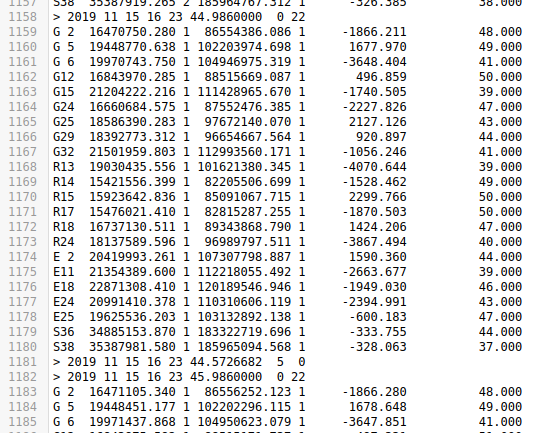
The above is a clip of a rover file. Line 1181 is an event. But the time tag is actually before the previous block i.e. time in line 1181 is before the time in 1158 and time at line 1181 does not have any sats observations associated with it - so are the coordinates written to the event file are an interpolation that I can assume will are also accurate to within few cm of the base assuming Q=1?
Tx
To be honest, I don’t know. Maybe somene else has something to add here.
Hi @gast,
Just verifying one last thing in terms of events - assuming the above then the events will also be at the absolute accuracy of the base (+/- few cm assuming Q=1) after post processing?
If the base stands on a known point, the image centers will be determined with absolute accuracy. If there’s a Fix, they will be centimeter-accurate as well.
time at line 1181 does not have any sats observations associated with it - so are the coordinates written to the event file are an interpolation
Yes, the positions of image centers are interpolated during post-processing.
ok thank you @kseniia.suzdaltseva
This topic was automatically closed 100 days after the last reply. New replies are no longer allowed.
Hi guys,
Just wanted to leave a couple of updates to my old comment:
-
We now provide Emlid Studio PPK software, which has a Stop&Go mode. It allows you to easily get separate points in post-processing.
-
The ReachView 3 app provides different options for setting your base. You can not only enter the base’s geographic coordinates in different datums, but also pick a point with local coordinates from one of your projects. It’ll be used as the base’s position.