My Leica Geo Office fails to Post Process RINEX data coming from Reach RS2.
I used Emlid Studio 1, Beta 10 to convert raw UBX files to RINEX 2.11 and 3.02, selected RS2 as the receiver and indicated the measured height (1.210m).
I can successfully import the RINEX data into LGO, but when I run static post-processing it resolves to Float with L1 only.
Most of the Antennas in LGO have Elevation and Azimuth correction parameters. Are there any for Reach RS2?
Hi, @Vusal ! This is a recurring question here in Brazil as well.
The RS2 receiver antenna only tracks L2C and not both L2C and L2P, this information is in their catalogue. LGO, by its “age”, only recognizes the L2P band.
Therefore, only the L1 band is processed in LGO or any older software, such as TopconTools or GNSS Solutions, for example.
In addition to Emlid Studio, newer post-processing software will recognize the L2C band, such as Leica Infinity, MagneticTools, among others. I personally have never used these software to post-process RS2 data, so my suggestion is only technical.
Does your Infinity have an active L2C band processing license? It could be something related to that. The Leica Infinity that we have in our company is a complete demonstrative license, which carried out the L2C import properly. Have not tested with Topcon MagneticTools.
Furthermore, I suggest that you perform a test with Emlid Studio. It is free, based on open source, compatible with Emlid’s GNSS solutions and without these paid limitations…
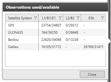
Managed to get a Phase Fix solution in Infinity with GPS/Galileo/Beidou, but only L1/E1/B1/E5b.
I cannot verify if there is a separate license for L2C band.
I can get Fix L2 in Emlid Studio, but it does not allow performing Network and Loop Adjustments.
The following warning message comes up after processing is finished: Missing orbits for satellite G22, R11, E20, E30, C10
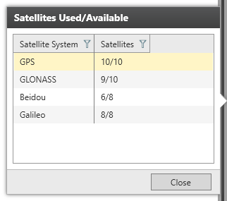
Besides, I can see inside Infitiy that RINEX data contains all the necessary GNSS data except for L2:
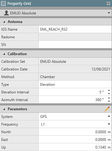
In this case the calibration is GPS only, not multi-constellation. But it doesn’t vary much, it’s not a reason to cause big differences in measurement or loss of accuracy.
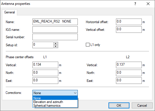
Usually, if you add the antenna name or ATX file, all the parameters should be filled in automatically. Does Leica Infinity support that? It’s just the best way to fill them in correctly.
However, here’s the ATX file. We have antenna calibration details for GPS L1/L2 and GLONASS L1/L2. If you search “EML_REACH_RS2” in this doc, you’ll find North, East, and Up values for each frequency.
Both Elevation and Azimuth intervals are 5º.
If correcting the antenna parameters doesn’t help, I’d suggest clarifying with Leica support if they have additional requirements for L2 frequencies. We’re always ready to make our logs compatible with other software.
I can get a 100% FIX Solution with Emlid Studio, but unfortunately it does not generate any processing report to show what satellites and frequencies were actually used for the computation. The result is just a .pos file.
Besides, the biggest disadvantage with Emlid Studio is inability to post-process the same point from 2 base stations and average/adjust the final result based on 2 baselines.
I got your point about network adjustment and baseline processing. But why do you need such a detailed report? I’m asking because we may think about adding this data to output, but we need to understand the application fully.
Regarding the Leica Infinity processing issue, it seems they have other requirements for L2 frequencies. As I said above, it’s better to ask their support what’s going on. If they find the cause of this incompatibility, please let us know.
We need to prove to our clients that we do implement Quality Control and Quality Assurance while reporting accuracy figures. There is no way of control with a single baseline.
Both Leica Geo Office and Infinity provide Summary and Detailed Reports of all the processing. This ensures confidence and proof of work.