Reach M+, getting fix is really difficult

Hi, I am using a Reach M+ as a rover, and the Android app to control it. The same phone is the hotspot as well. My Base correction is coming through NTRIP, the base is within 2kms, and the delay is usually under 1.5 second. The region is more or less free of occlusions (2 floor buildings ~50 m away).
I have trouble getting a stable fix. Reachview version: v2.16.2. System report attached at bottom.

Steps:

  1. Start hotspot
  2. Start reach m+ (connects to hotspot)
  3. Place reach in the middle of the field, antenna far from powerbank, or reach
  4. Wait for fix

Observed problems:

  1. Getting fix takes a long time, sometimes won’t happen in 20 minutes
  2. Both base and rover sees lot of satellites (above 15), but very few are green
  3. Sometimes we get a fix, but lose it immediately, even with fix and hold
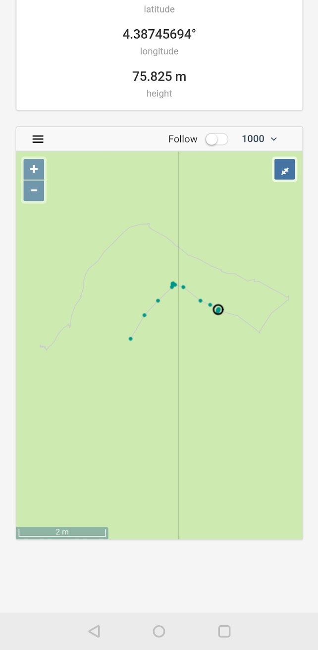
  4. Sometimes with a really strong fix (AR=999) the position won’t change when rover moves. On the map in the app, the green dots stay, but the gray line (what is that?) seems accurate and follows it
  5. Downloading the logs on Android does not work, the download button literally gets stuck

I need a reliable solution to get an accurate position. Any advice on my settings is welcome, I am new to the topic.
Post processing is also an option if you say it will solve my problems, but would be nice to see on the field if it is working (e.g. if it says float on the field, can I get fixed solution in post?).

Thanks a lot!
Andras

Simple system report

app version: 2.16.2-r0

'wifi_status, interface: wlan0':

- wifi_mode: infrastructure

- ip: 192.168.43.98

  is_added: true

  is_connected: true

  is_visible: false

  mac_address: 28:ED:E0:D6:77:7F

  security: wpa-psk

  ssid: trololo

  uuid: 63475fde-9c20-49b8-8a11-96e65f59dc51

base mode:

  base coordinates:

    accumulation: '2'

    antenna offset:

      east: '0'

      north: '0'

      up: '0'

    coordinates:

    - '0'

    - '0'

    - '0'

    format: llh

    mode: single-and-hold

  output:

    enabled: true

    format: rtcm3

    path: tcpsvr://:9000#rtcm3

    type: tcpsvr

  rtcm3 messages:

    '1002':

      enabled: true

      frequency: '1'

    '1006':

      enabled: true

      frequency: '0.1'

    '1010':

      enabled: true

      frequency: '1'

    '1097':

      enabled: false

      frequency: '1'

    '1107':

      enabled: false

      frequency: '1'

    '1117':

      enabled: false

      frequency: '1'

    '1127':

      enabled: false

      frequency: '1'

bluetooth:

  discoverable: false

  enabled: false

  pin: '***'

camera:

  duty cycle: 20

  enable: false

  period: 2

  polarity: true

correction input:

  input2:

    enabled: true

    format: rtcm3

    path: 3me:***@[gnss1.tudelft.nl:2101/DLF10](http://gnss1.tudelft.nl:2101/DLF10)

    send position to base: single

    type: ntripcli

  input3:

    enabled: false

    format: rtcm3

    path: :9028

    type: tcpsvr

logging:

  base:

    format: RTCM3

    started: false

    version: null

  correction:

    format: RTCM3

    started: true

    version: null

  interval: 1

  overwrite: true

  raw:

    format: UBX

    started: false

    version: null

  solution:

    format: LLH

    started: false

    version: null

lora:

  air rate: 2.6000000000000001

  frequency: 868000

  output power: 20

position output:

  output1:

    enabled: true

    format: erb

    path: ttyMFD2:38400:8:n:1:off

    type: serial

  output2:

    enabled: true

    format: llh

    path: :9001

    type: tcpsvr

  output3:

    enabled: true

    format: llh

    path: :2014

    type: tcpsvr

  output4:

    enabled: true

    format: llh_ext

    path: :2015

    type: tcpsvr

rtk settings:

  elevation mask angle: '15'

  glonass ar mode: 'off'

  gps ar mode: fix-and-hold

  max horizontal acceleration: '2'

  max vertical acceleration: '1'

  positioning mode: kinematic

  positioning systems:

    compass: false

    galileo: true

    glonass: true

    gps: true

    qzss: true

    sbas: true

  snr mask: '20'

  update rate: '5'

A few inputs from your comments and the report:

  • Set Glonass AR to on
  • Experiment with increasing the Elevation mask angle, try 20 for a start.
  • Can you post an image of your antenna setup and drone-setup in general ? It sounds like the antenna-environment is sub-optimal
1 Like

Thanks a lot for your quick answer.

  • I have read it here that Glonass AR should be turned off if base is not reach (it is not). I can of course turn it on anyway! :slight_smile:
  • Elevation mask is low to have more Satellites used, but you are right, with buildings around, I might just make it narrower.

What do you think of the used satellite types and the SNR?
Also do you know what the gray line is on the map view? see screenshot.
Going out to try these now. Thanks a lot again!

Correct! Thanks for reminding me!
On that note, what is your baseline?

The better SNR the quicker the fix, usually. But being close to structures can of course introduce multi path, and then you’re a bit screwed.

This “just” looks like a plain cosmetic bug that needs reproduction and fixing from Emlid dev.

Play with your your constellation groups. What constellations are you using? Try starting with GPS only then add them one by one. I would suggest keeping a logbook for different areas. I have a couple that get poor GLONASS communication.

1 Like

Hi, so I should not use Glonass AR afterall? I went out with 25 elevation mask, GLONASS AR turned on, SNR to 30, and got fix in reasonable time (3-4 minutes).

About the baseline, the base is 1.9 km away, and should be super accurate (one of the reference stations for the global systems: http://gnss1.tudelft.nl/

About the cosmetic bug: ok that sounds reassuring. Unfortunately it happened several times, but I will ignore it then.

1 Like

Thanks for answering!
for now it was everything but BEIDOU. A High framerate is required for the application, so I cannot go under 5 Hz.

If it works, I don’t see why not!
3-4 mins isn’t too bad at all!

Thanks! What is your average?
And would you suggest to use post processing if it is possible?

Hi András,

Could you please share the photo of your antenna setup?

1 Like

Anything between 1 mins and 10 mins. Sometimes not at all though, then switching/cycling once between Static/Kinematic usually helps. Fix-and-hold usually gives me a fix slightly faster.

1 Like

Hi @palffyandras,

@wizprod is right, it’s better to turn GLONASS AR mode on. From v2.14.0 ReachView version, Reach is able to correct GLONASS inter-frequency biases, allowing for GLONASS AR with non-Reach bases.

We’ll fix that in our docs as well. Thanks for noticing!

2 Likes

So you are wanting to run less than 5hz on your Rover? I would run five as a minimum.

Hello, the antenna is usually tied to the top of my head, facing up. There is no ground plane, because we use radar and afraid that metal ground plane would mess up the recordings. This is the intended use-case. To get a fix, I usually place it on the car hood first. Is this enough, or should I post a selfie with it? :smiley:

Alternatively, purely for test applications (to calibrate with other sensors) we also place the antenna on a plastic tube elevating it from the ground by 50 cm.

I think you misunderstood me, 5Hz is the minimum we could use, 14 would be better, but it also means less satellites.

You’ll have to post a selfie… obviously only for educational purposes of course… not because I want to see a facemounted GNSS-antenna at all, noooo no! :smiley:

2 Likes

Thanks for confirming! I will leave it on then :slight_smile:

1 Like

I guess you earned it :smiley:
That is me, with antenna on the top of my head, reach M+ and powerbank in front pocket.

1 Like

Awesome ! :smiley:
A 12-14 cm diameter groundplane, along with keeping the antenna level at all time will help immensely on your signal quality. As your setup is currently, you’ll have a lot of multipath-issue coming from the ground.

How do use You a radar in a way that a groundplane would interfere? Doesn’t healthy to be that close to radar-device!

1 Like

It is an automotive radar in the car!