


Yes, but that is only true for a PPK solution, where you can determine the lag between camera-trigger and position.
You can test with almost any GNSS solution, also our reach units. Move your rover rod, and observe how much lag there actually is between the movement, and this being reflected in Reachview.
1 Like
Buen día me Gustaría que alguien me explicara sobre la instalación del dispositivo M+ en el drone y en el gps, y que dispositivo debo adquirir pars que nuestro mavic 2 funcione con el Rs+, me refiero a la instalación y armada
Saludos
I like the idea of PPK drone but I think that GCP’s is needed anyway.
I use a standard Phantom 4 and I get very good results following the rules:
- Fly altitude 30-60m (with P4A/Pro I could use up to 120m altitude)
- Fly double grid mission if possible for better vertical results. Overlap minimum 75-75 and usually 80-80.
- Layout GCP’s inside the perimeter of the project and in the middle, usually 8-10 GCP’s.
- Measure the GCP’s with RTK GNSS. Base-rover solution is preferred because of tighter vertical results. Network rovers produce less accurate vertical results.
PPK with less GCP’s is the best solution right now I think.
2 Likes
How does your GCP network scale? 10acrEs vs 100 and etc? I use:
4 on 10ac, 5 on 25, 6 on 50, 8 on 100-500 acres. Of course all of these are subject to change with the shape of the site. Sometimes more sometimes less. For those of you who breeze through posts, THIS IS WITH PPK. Without would be close to double that.
1 Like
I agree.
To be able to perform a topographic survey with only 15 minutes of flight would be a dream.
We will probably get there … it will probably be possible one day (and at low cost) … but at the moment, as much as I hate them, GCPs are fundamental …
I usually place a GCP every 50-70m but it depends on the relief also.
Oh I forgot the most important thing, I use MapPilot with terrain awareness feature. My region is not flat so the terrain following is very important for me.
If the modification of the Phantom 4 was easy I would be happy to make some PPK tests but for me is a no go right now.
1 Like
This is what you need.
http://www.tuffwing.com/products/Phantom_Reach_PPK_Integration_kit.html
1 Like
Tinab, about when do you expect the upgrade kit to be available?
Unfortunately this works only for P4 Pro/Adv.
I own P4 standard…
We would like to share our experience how TOPOSETTER 2 PRO software helps to post process GNSS data and create 3D model with 1-3 cm x,y,z accuracy in Israel local coordinate system (IGD 05/12)**
In the blog below, we want to present you our latest software development, which is designed to greatly automate and simplify the GNSS measurements processing and initial preparation of aerial photography materials for subsequent photogrammetric processing.
We will show all the main features of our new product based on project, were carried out by our advanced users and partners from Israel Geoscan Ltd. Advanced UAS Service & Solutions http://www.geoscan.co.il/
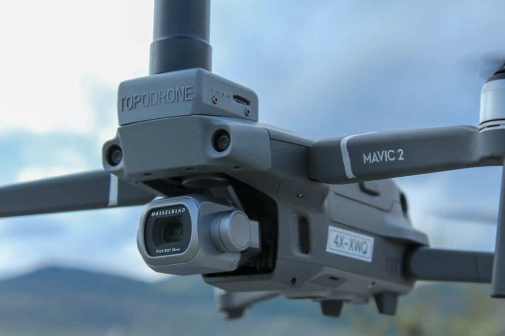
The Geoscan Ltd. (CAAIL- Air Operation Certificate No: 088292019) is a highly professional user of TOPODRONE solutions, in particular the DJI Mavic 2 Pro L1 / L2 RTK / PPK . Geoscan Ltd. has a huge experience of service providing in complicated projects of precise geodetic surveys and measurements by using UAS based solutions, as well as DJI Phantom 4 RTK (Alternative solution).
We have selected an area with more than 200 measured GCPs for testing. These GCPs will be used for coordinate and terrain 3D-model quality control
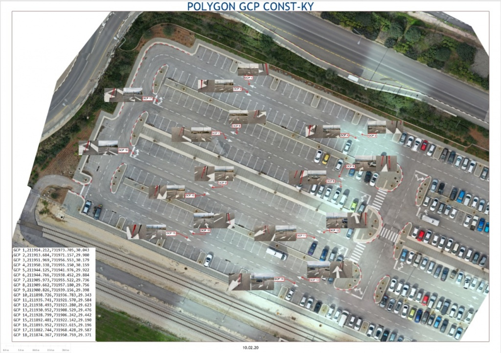
Pic 2. Location of the work area and control points…
Aerial photography was performed by Topodrone DJI Mavic 2 Pro L1/L2 RTK/PPK from a height of 40 meters at a speed of about 4 m/s without installing a GNSS base station.

We have downloaded a virtual Rinex file from the web-site http://etkes.com before the data processing.
It was coincided by a time with the aerial photography and drone’s .ubx data.
Next the following data set was loaded in the TOPSETTER 2.0 Pro software:
- Folder with images of the first flight
- UBX file from the drone
- Rinex file from the base station
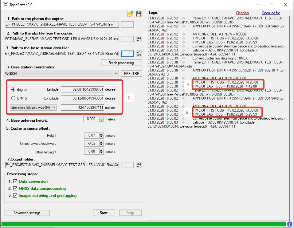
During the import, an information window shows the start and the end time of GNSS measurements of the base station and the drone, as well as the coordinates of the base station in the WGS84 system.
Pic. 5. Updated TOPOSETTER 2.0 Pro interface.
After entering all the source data, we selected the output ISRAEL IGD 05/12 coordinate system . Also, we set the necessary elevation system, and launched the automated post-processing of GNSS measurements and images georeferencing.
ISRAEL IGD 05/12 coordinate system was added to TOPOSETTER 2.0 Pro App with using an official information from government agency for Mapping, Geodesy, Cadaster and Geoinformatics www.mapi.gov.il.
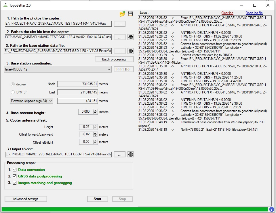
Pic. 6. TOPOSETTER 2.0 Pro , selecting the output coordinate system.
The following data set was obtained based on the results of post processing:
- Geotagged images in EXIF tags (Latitude, Longitude, Ellipsoid height and accuracy)
- Text files with images’ coordinates in WGS 84 and ISRAEL IGD 05/12 systems
Next, we created a Pix4Dmapper project with a set of aerial photos. Pix4Dmapper
automatically calculated the coordinates of the images and their accuracy.
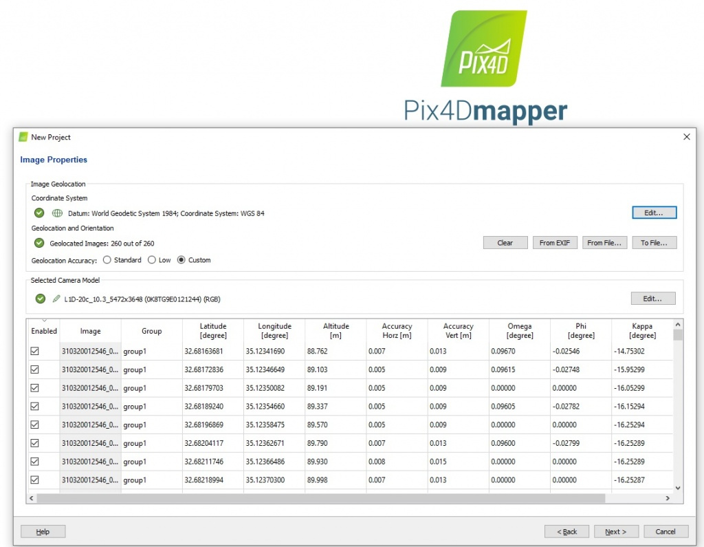
Pic. 7. Automatic import of image coordinates and their accuracy.
Then we selected the Israel Grid 05/12 coordinate system, uploaded a text file with XYZ coordinates created as a result of post-processing in TOPOSETTER 2.0 Pro , and started the automatic aerotriangulation process.
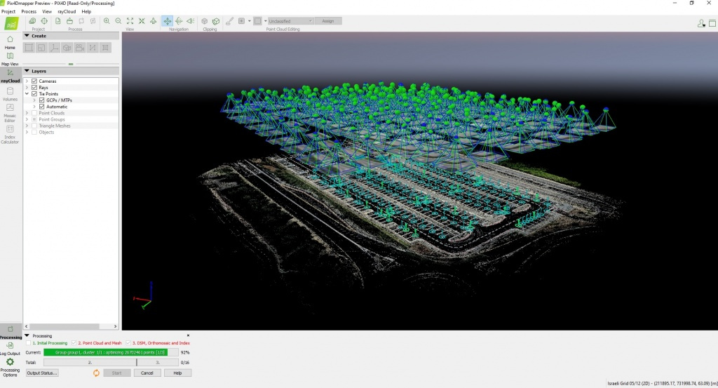
Pic. 9. The control points and routes locations of aerial photography in Pix4Dmapper.
The processing report in Pix4Dmapper is presented below.
RMS errors on the XYZ axes were 1.15, 1.16 and 2.9 cm , which respond to the GNSS measurements accuracy in RTK mode.
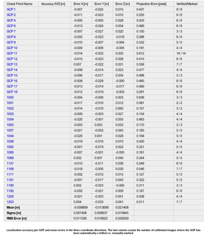
Pic. 10. Accuracy control report of building a digital terrain model.
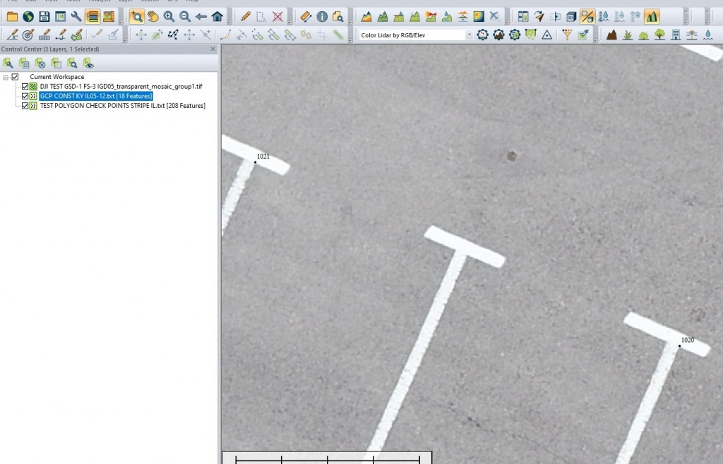
In the figures 11-12 show the results of comparing the position of control points on the orthophoto.

TOPOSETTER 2.0 Pro allows post-processing of GNSS data in any coordinate systems set by a user, and provides a high level of accuracy.
The software has additional automatization capabilities that greatly reduce the quantity of manual work and save time allocated for preparing data for further photogrammetric processing:
- Batch processing of multiple flights from a single base station
- Automatic images renaming, which is very useful for large number of flights and aerial photography processing
- The ability to save a text file with coordinates in formats compatible with Pix4Dmapper and Agisoft Metashape
- Additional settings for GNSS measurements
- The function for calculating the camera’s calibrated focal length
- Loading coordinate systems from a PRJ file
- Processing of the GNSS measurements in any coordinates system
- Calculating the coordinates of the base station using PPP technology
6 Likes
I already have the materials and equipment needed, it’s just still difficult to arrange … can you help me?
Hi, tinab, Could you please share the dataset again? I have read your post while the resources are unavailable anymore.
Hello,
How could i do the post processus with toposetter 2.0.
Toposetter is free?
Beaucause WE have projected to oder the systèm Emlid and Mavic 2 pro updated PPK kit.