This is just a quick comparison test to see the deviation in measure for lat, long and height and a first step to somewhat verify a new known point. Had no plan with it so things just falls/roll’s as i go.
I use two Reach units, accompanied with homemade pole and tripod setup. Bare in mind there could be some minor offset in distance from antenna inside the CD box as i did not measure it accurately during assembly  Probably +/- 5mm in all directions. There is also some deviation i accuracy when leveling thing out, its not the best gear used.
I have uploaded log files here
rover_base _201702031803.zip (5.0 MB)
Started out with the rover, this will be the unit surveying for a new known point, and files is saved as rover_xxx.
I leveled it out and measured the distance from ground to antenna to be roughly 2000mm. Enabled raw logging.
Then i drove of to set up the base. This is placed over a known point. Antenna is about 1036mm above the bolt on the ground nd started raw log. Files are named base_xxx
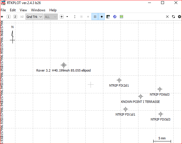
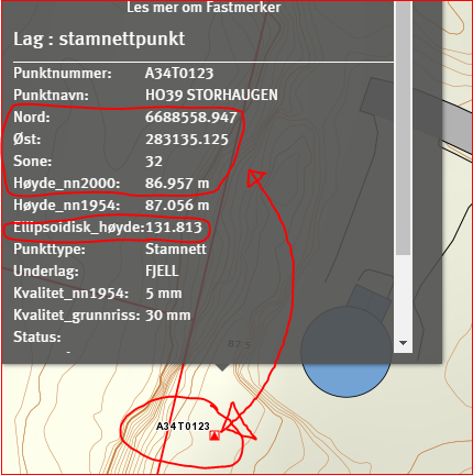
Pic. under you can see coordinates im going to use later with RTKPOST.I am also using height model NN2000 (red ring around) Coordinate is UTM zone 32
pic 1
There is a Href tool to be used, skHref.
You can download it here ftp://ftp.geodesi.no/
And you need to use this Href model HREF2016B_NN2000_EUREF89 (3).bin (1.9 MB)
After install, apply Href model to skHref (red ring with nr 1.) Once done, you can open new tab (red ring nr 2.) and apply coodinates to where you want geoid height and get result in window shown in picture below.
Bytt HREF-model = Switch HREF model
Finn geoidehøyde = Find geoid height
pic 2
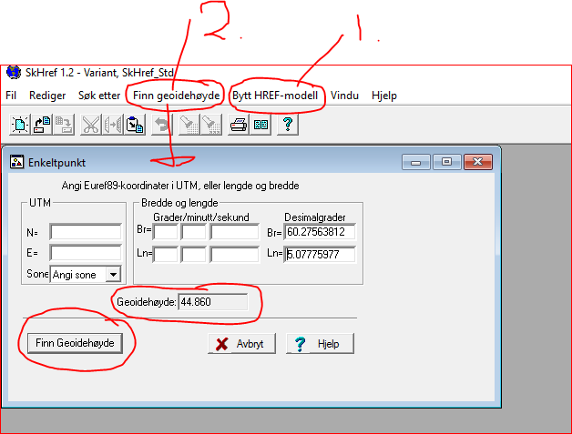
Now you can test if values in pictures 1 is correct. Fill in N and E coordinates in UTM area and select Zone 32 and hit Finn Geoidehøyde, You should get something around 44.xxxx , This you subtract from Ellipsoide height found in picture 1. Its 131.813 and the result should be 86.957m (høyde_nn2000) or close to it by few millimeters of. This result is orthometric height.
Now that we know this work, we can apply this to ellipsoid height given to us by postprocessing raw log files.
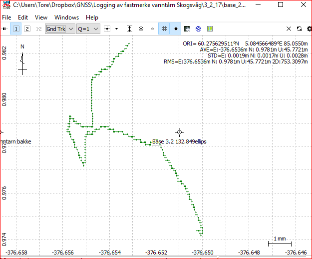
I get average of out if the RTKPLOT window. Average value here is difference from base to rover, its either above or below base known ellipsoid height.
Remember, before you postprocess, you need to set the actual ellipsoid height for base under positions. See pic 3
The height value below is not correct: I use coordinates from rover to cross check values which i explain further down.
pic 3
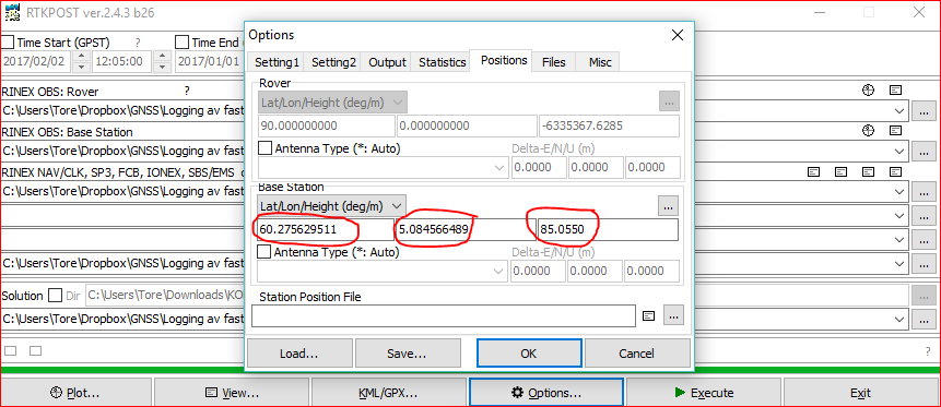
From pic 1 we know that ellipsoid height at base i 131.813m and antenna is 1.036m above this, i then get 132.849m
If we then subtract average value that’s been post processed (-45. something, if i remember correct) ,you should get 87.055m above ellipsoid. But antenna used on pole (rover) is placed 2m above ground, so we need to subtract 2 more meters and final ellipsoid height would be 85.055m (height above ellipsoid)
To check if position is correct we could do this the other way around, now that we known coordinates for rover.
We swap files to process and changes position values to correspond with the values for the rover. Remember to adjust for offset values (antenna 2m above ground for surveypole). picture 3
The result if done properly, would be the coordinates displayed in picture 1, +/- x mm.
We now have the exact ellipsoid height for the rover and can calculate this to orthomteric height, which gives me an height above sea to be 40.199moh (meters above sea / orthometric height).
For short distances it could be calculated like this. Ellipsoid height minus høyde_nn2000 height (found in pic 1) = 131.813m - 86.957m = 44.856m (difference value)
If i subtract 44.856m from my ellipsoid height at rover ( 85.055m) i get an orthomteric height for rover to be 40.199moh
Warning. This only applies to short distance as Geoid model will change with the distance you have between to points.
The right way is to use skHref, fill in coordinates from rover and hit apply (finn Geoide høyde). Output values here is subtracted from ellipsoid height post processed from rover.
If you compare skHref and difference method, you see it only differs few mm, which is good enough for me.
But further away you get from base or origin, the greater the offset is.
NB! skHref only applies to Norway.
Here is some screenshot in random order.
Thank you for reading and hope my low level English didn’t mess it up to much