I was just doing some reading and saw that WGS84 is now at a new realization?
So does this mean that our Emlid RS units are now using WGS84 2296 instead of 2139?
Also, I am just reminding US users, the new horizontal and vertical datums are getting closer. If you goto NGS you can already start playing around with them.
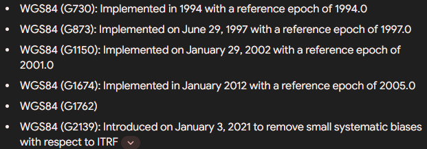
I’ve seen this question 3 times in the past two days on different platforms I also would like to understand how these updates propagate through systems. Is it part of the GNSS system and is just the data we interact with or is it something that hardware manufacturers need to deal with utilizing software and/or firmware? From what I do understand the differences between the individual WGS84 datums is fractions of millimeters but over time it has grown to some around 1.5m?
…and while I am excited for the new SPCS we probably won’t see it fully utilized for additional years. The project that I am on right now still has GEOID 12b…
Reading some information from the “owner” of GPS, it seems like the new realisation/update of WGS 84 is more to align the clock products of the satellite data to ITRF2020.
While most of us at some point use some form of processing (RTK/PPK/PPP) where both the base and the rover data is basically data matched to the same point in time, I think you will only notice the difference if you are comparing WGS 84 Co-Ordinates between epochs/realisations of WGS 84.
For me, I don’t think there would be any real change using my local CORS (AUSCORS for example) with my survey being on the same datum (GDA/MGA) before or after the new realisation. Same too if I was to post process through AUSPOS, as all things are relative to each other when you start comparing baselines or organisations who provide these services are probably all over it and have already got the transformation built in (if needed).
Happy to be proven wrong here, but I think the change will only be more noticeable to those who would rely on raw satellite data for position, like handheld GPS.
Great information from everyone.
I wasn’t expecting any real change either.
For me it was a bit exciting since I saw this as a step towards the new US horizontal and vertical datums since my understanding is that they will be related to ITRF 2020.
For fun, I transformed a few of my old projects to ITRF 2020 and then converted to the new State Plane for my state. The new alpha geoid is also available so I also transformed my elevations to get a new orthometric height. In my favorite test area the orthometric height is lower by about a foot with the new vertical datum.
My Emlid units and drones are not just professional tools, they are also my toys for when I have excess time, LOL.