


I hope this isn’t off topic. I just wanted to inform all the loyal QGIS fans among the Reach users that it’s time to check out a new major release of QGIS!
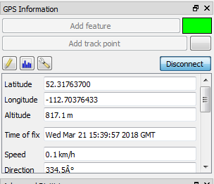
For those that don’t know QGIS, it can connect to your Reach and be used as a free and open source survey tool for collecting points and creating linework, etc.
Check out some of the new features at the link below!
My favourite thing so far is improved CAD tools, drawing proper rectangles, etc.
