I wanted to share my promo video where I used images from work done using the Reach base and ground stations for aerial surveys.
This equipment is working flawlessly for me in the field.
I wanted to share my promo video where I used images from work done using the Reach base and ground stations for aerial surveys.
This equipment is working flawlessly for me in the field.
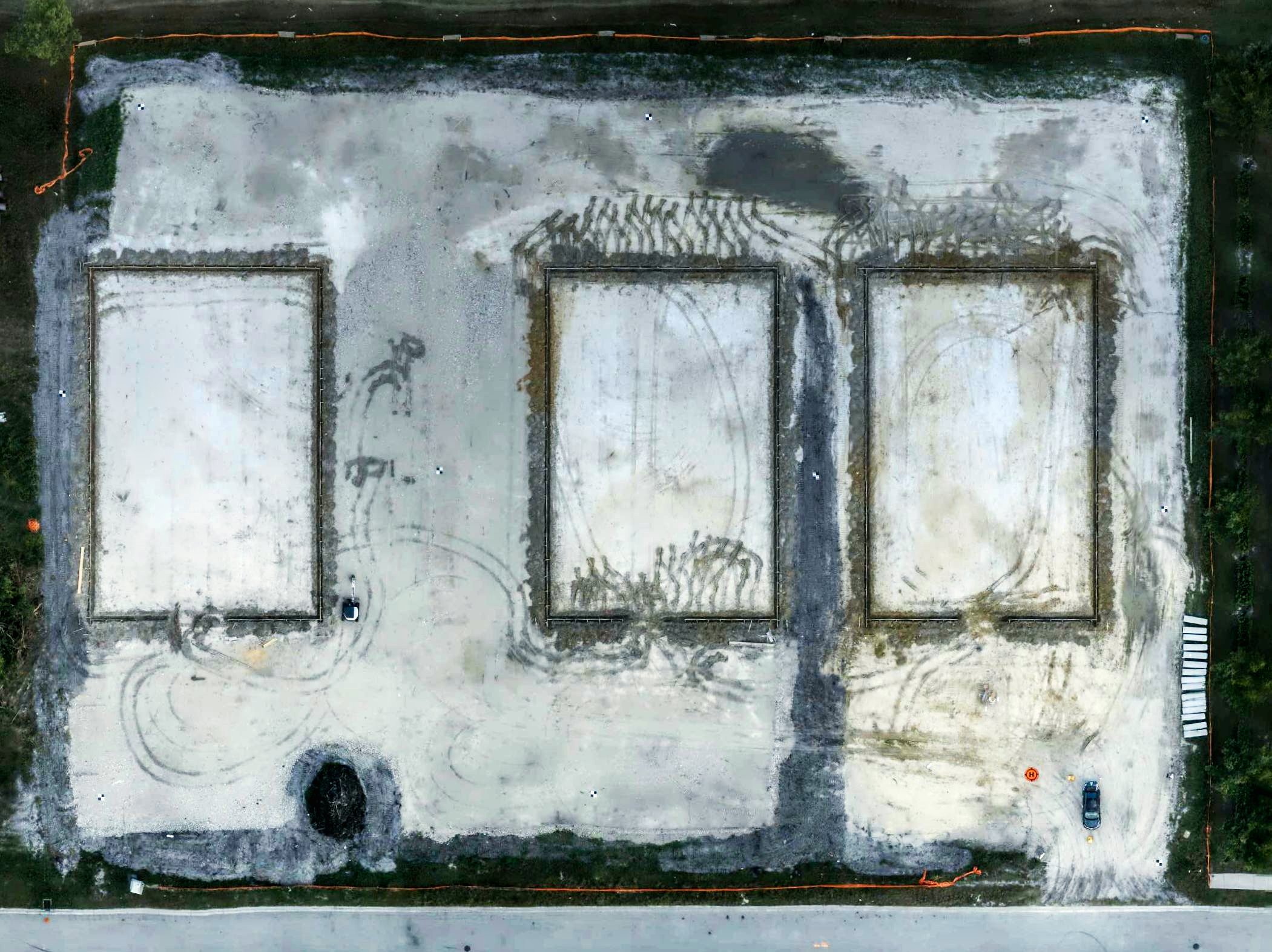
The first two projects in the video I used the reach units to identify specific landmark points in order to store GPS ground data. I also used ground measure as a back up to check that the unit were capturing correctly. They were very accurate to within 1.5". The video projects are from 10 to 54 seconds. The third project was only shown as an elevation for construction progress. However, I did capture the entire site at the foundation stage (see attached) and used GCP’s which can be seen in the attached image.
My set up is as follows
SUAS - Yuneec H520 with an E90 camera
Emlid Reach RS base with remote.
Software - 3D Survey which handles the GCP’s perfectly.
I did several practice runs with GCP’s places within 20’ of each other and captured the GPS data along with aerial data. I was able to verify the accuracy of the reach units to the aerial images with each practice run done in 3 separate locations about 20 miles apart. The reason for the distance was to be forced to calibrate the H520 compass and cross check the exif data against the GCP’s.
With all of my projects I place a minimum of 10 GCP/landmark locations.
I am using the reach units in Florida (US) where the elevation is relatively flat so altitude is not really and issue.
Just curious as all, as I haven’t delved into using drones etc (YET!)…I just use (2) RS units for other things… but curious, what exactly is something like this used for? Just curious really as I haven’t looked into it (or Googled the subject…we all know it all once we do).
Is it something (a deliverable, a file, vide, images etc etc) you provide a construction contractor, engineer, owner for their use? Is it for a survey company? Wonder if and how many people that provide this service are “registered land surveyors”? Seems they should be, right? for it to mean anything, correct? Like a Engineer’s required signed and sealed set of engineering plans in order to build something for the public verifying for the most part it’s all been checked over and functions by a licensed professional to be held accountable if not.
Again, just really wondering as it seems everyone is buying drones (going off of the more expensive, the more “professional”) and this RTK/PPK equipment then providing something either they are accredited or not? If not, I think I will start looking into this also, but also look into getting registered also if need be. ; )
Again, seems everyone and their brother are jumping on the bandwagon and it’s FUN, so why not? Thank you!
There are some survey firms that have adopted drones for their work. It takes quite a bit of time to learn the art of flying a drone professionally and you must be licensed to fly commercially. You don’t need to be registered to take precision images so it fits well with me to supply the imagery and data to surveyors, builders and developers…plus there are many other places unmanned aerial vehicles are used in the construction industry. Takes $$ and time to bring it all together. There is a problem with inexperienced pilots using toys without any construction knowledge or experience that can really cause issues.
Well that makes sense. I was wondering what all the hype was with drones and surveying. Sorry, again, my work doesn’t involve drones, but sounds like a great way to make cash, especially if you know what your doing and it’s really on the registered surveyor, engineer etc to rely on what they get.
Thank you.
Very nice work! I also have a couple of H520’s so we need to collaborate getting the M+ setup so you only have to set 5 GCP’s. Over 600 construction maps here so I totally get where you are coming from.
This topic was automatically closed 100 days after the last reply. New replies are no longer allowed.