Just want to confirm some things about using NRCAN PPP for the base station while also simultaneously conducting a survey/drone flight:
-When gathering PPP points for use in NRCAN only gps and Galileo sats are used, does the Rover also need to be set to this or can it use all constellations?
-Is the average location (llh?) compared against the processed PPP rinex location to get a difference that can then be applied to all surveyed points .csv in excel? Or am I mistaken in the workflow…
(does the basestation change during data collection and therefore does the correction need to match this?).
In some cases I will be able to log for the day then come back later and manually set the base station, however, I also want to be able to complete a survey + PPP during the same day for smaller projects.
Yes, you can correct the points afterward when you receive the corrected base’s coordinates from PPP.
NRCAN doesn’t use all constellations, but it still accepts logs, which contain all constellations. So, you don’t need to configure additional settings on the receiver.
By the way, it’s always possible to exclude some constellations while converting in Emlid Studio.
Yes, that’s right. After you get the precise base position from the PPP service, there are two options:
You can calculate the shift from the base coordinates you averaged in Base mode and add this value to all your points coordinates in a CSV file
You can use a free Emlid Studio - our desktop application for PPK that we’ve recently released. It has a Stop&Go feature. You can post-process raw data logs from base and rover using the corrected base position. To learn more, you can check our docs
With PPP, you need to wait if you want to receive the best accuracy. On the next day, you will get about 5 cm (2 inches), and after 13 -15 days, you will get about 2 cm (0.8 inches) of the accuracy.
I could be wrong but, I was taught if the base isn’t using the other constellations, there is no advantage of the rover using them as they are not utilized in the RTK solution.
Also, if the base is using one the rover cannot, it can cause problems. I know this was an issue using Ohio CORS network with older equipment that was not GLONASS enabled but the base was. The Ohio CORS network actually came out with a mount point for this reason.
Below is a list of their mountpoints:
ODOT_VRS_ODOT_Ag: WAAS only, Trimble CMR format
ODOT_VRS_CMR_PLUS: WAAS and GLONASS, Trimble CMR+ format
ODOT_VRS_CMRx: WAAS and GLONASS, Trimble CMRx format
ODOT_VRS_RTCM2: WAAS and GLONASS, RTCM2 format
ODOT_VRS_RTCM3: WAAS and GLONASS, RTCM3 format
If you used an old Trimble receiver, 252 or 262, it would work with the Ag mount point. If you tried either of the CMR it would not work. Neither of these were capable of using CMRx but both were capable of CMR+.
Currently I am using all constellations available on both the base station and the rover but only logging the gps + gallileo (for PPP). Would this potentially result in some discrepancies in post processing? I was finding it was hard to get a good fix if I just used the two constellations.
You can turn on all the satellite systems in RTK. As you’ve noticed, it’s harder for GNSS receivers to calculate the exact position only with GPS and Galileo if you work in challenging conditions.
When you average base coordinates in Single, you obtain antenna phase center coordinates. To get the coordinate of a point on the ground, you need to subtract the survey pole height and 134mm (for Reach RS2).
You can enable GPS and GLONASS (not Galileo) when recording logs. NRCAN uses only these satellite systems to calculate coordinates. Also, this allows you to reduce the size of the recorded raw data log.
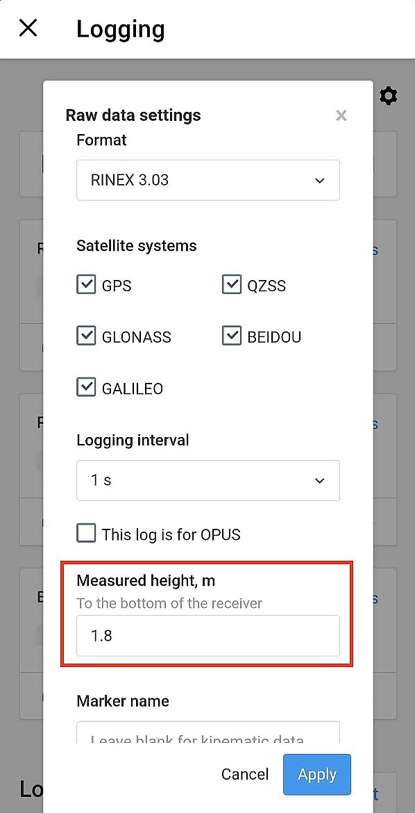
I’d recommend you record raw data logs in the RINEX format. If you add the survey pole height in the Measure height tab, you get the coordinates of a point on the ground in the processed PPP file.