


@richie1aubyn Which RTKConv version did you used and what was your configurations for the conversion of the UBX fIles to be used inside TOPCON Tools. Or did you used a third party software or TOPCON LINK to have more ease in processing in TOPCON TOOLS?
Completely forgot to upload my results. As no rover antenna height was given, I have used 0.134 m to null out the RS2.
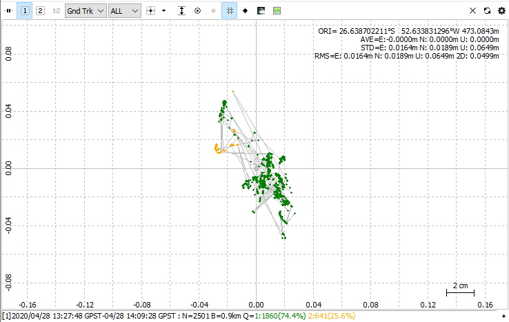
Rover 1:
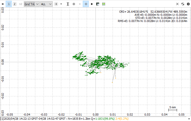
Rover2:
Great, can you share your configs as well? I will be comparing with my results, with luck today i finish other processes of theses points to add to the comparison. Thanks @wizprod.
Hello everyone, finally i was able to finish comparisons with all the processes and was able to pass the findings to a client who was not very confident with the results of their post-processes in RTKPost.
Here are the results:
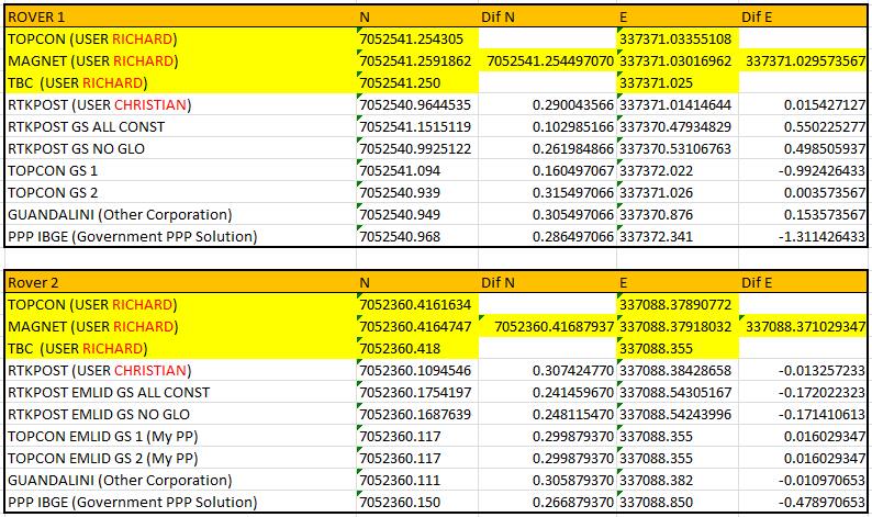
I used @richie1aubyn’s processes as reference since the 3 processes gave milimetric difference between one and the other. With them i made an average coordinate fo the 3 and used those averages as comparisons with the other processes.
It’s importanto to note that @richie1aubyn had a difference in his base coordinates, in his tests he use in the North -26º 38’ 25.14320’’ and in the PPP file and also in my head post is at -26° 38’ 25.1532". This makes a 30cm difference in the north coordinates from the other processes.
So, i basically used Topcon Tools V 7.5.1, RTKPost 2.4.3 b28 from the Emlid Docs, also i have sent the files to a partner in São Paulo called Guandalini, who is developing a post-process software based on RTKLib code and finished by sending the files to the Brazilian PPP government solution available in this site: https://www.ibge.gov.br/geociencias/informacoes-sobre-posicionamento-geodesico/servicos-para-posicionamento-geodesico/16334-servico-online-para-pos-processamento-de-dados-gnss-ibge-ppp.html?=&t=processar-os-dados
Note that the site isn’t in english and they don’t have the radio specs from the Emlid RS so i had to insert the antenna height manually.
Since this is a forest survey and our national technical regulations for rural surveys, called INCRA, says that a fixed point in a forest situation must have a maximum of 50cm of error in the standar deviation.
Again thanks so much for everyone and for your contribution!
2 Likes
Please, ckeck out a more recent version of rtklib.
I recommend this one: Demo5 b33c
Good luck
1 Like
Hello @tiedtke, i’m gonna check and test this version of RTKLib! Thanks for sharing!
This topic was automatically closed 100 days after the last reply. New replies are no longer allowed.