


I have an Emlid Reach RS2 as a base station.
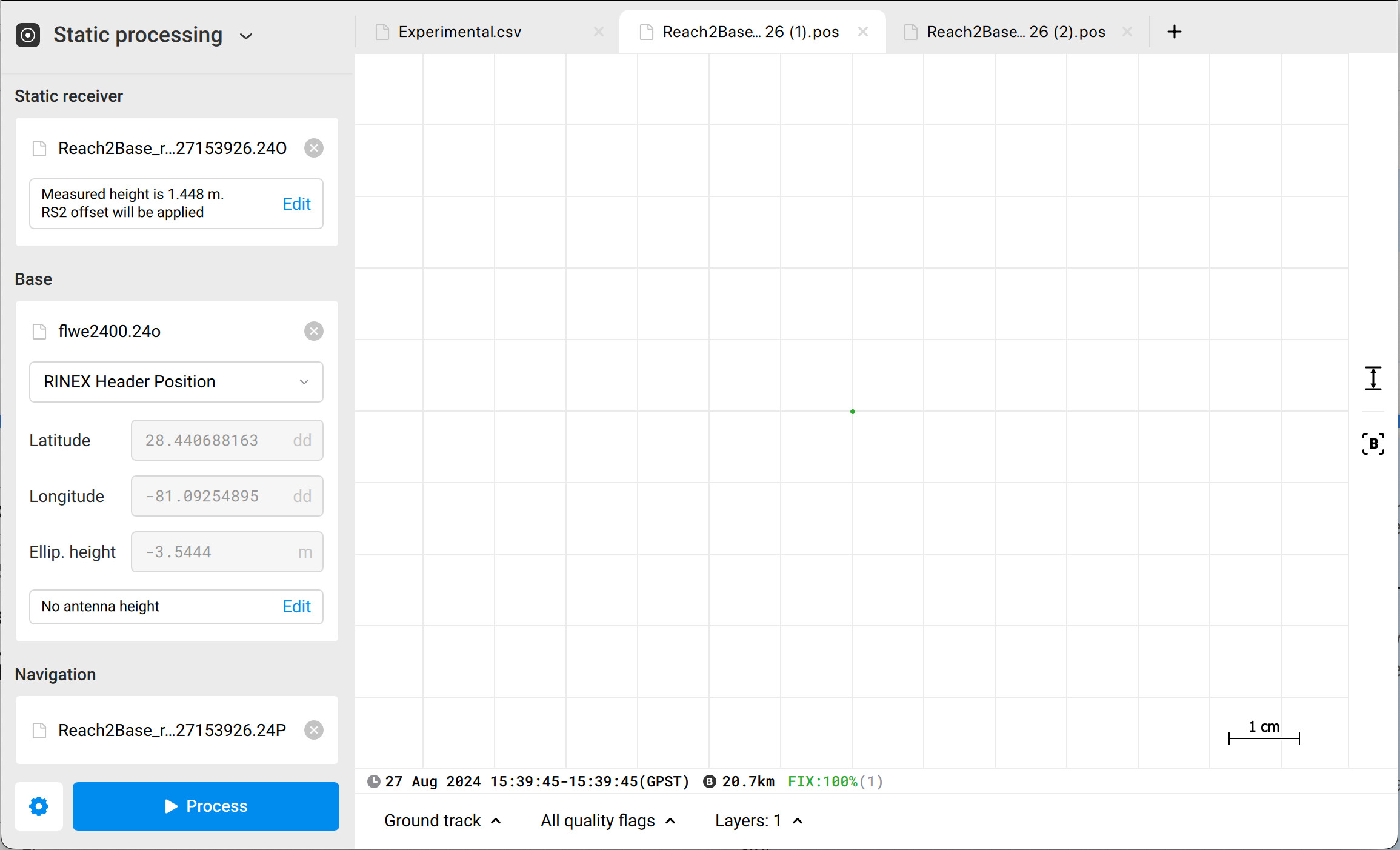
I tried to post process the coordinates using Static processing on Emlid Studio. The coordinates came out a little different from what I had when averaging the position; is it possible to get the same coordinates?
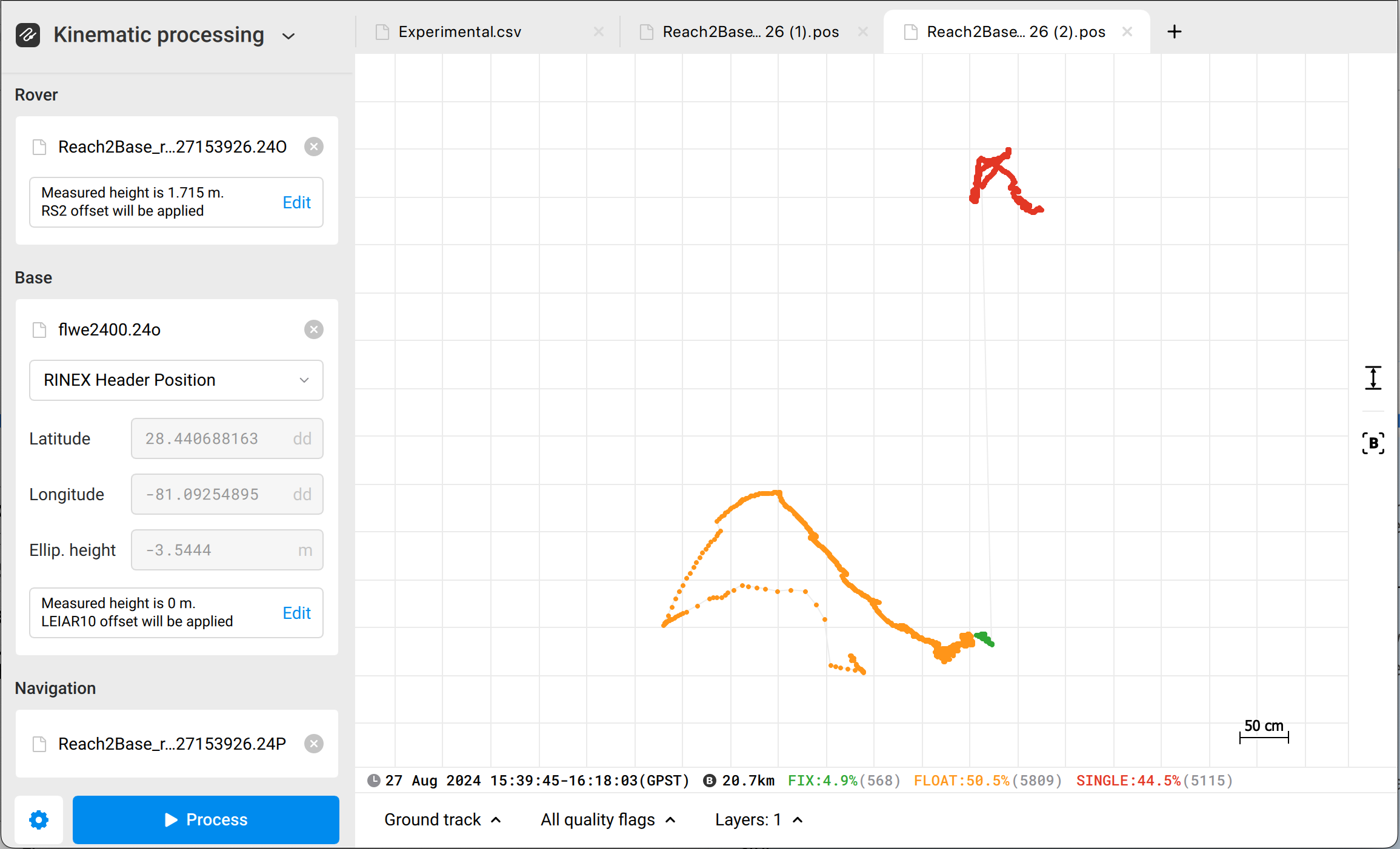
Then I tried to use kinematic processing to get the coordinates but it is way off, since I set the averaging time to 20 minutes, I wonder if Reach RS2 is logging the data while averaging its position.
Hi Jinwen,
You’re right. The coordinates from average FIX and Static processing should match. Can you please share the raw data from Reach and the CORS with me? I’ll look into them. You can also email them to support@emlid.com as it may contain sensitive information.
Besides, which NTRIP service did you use for averaging in FIX?
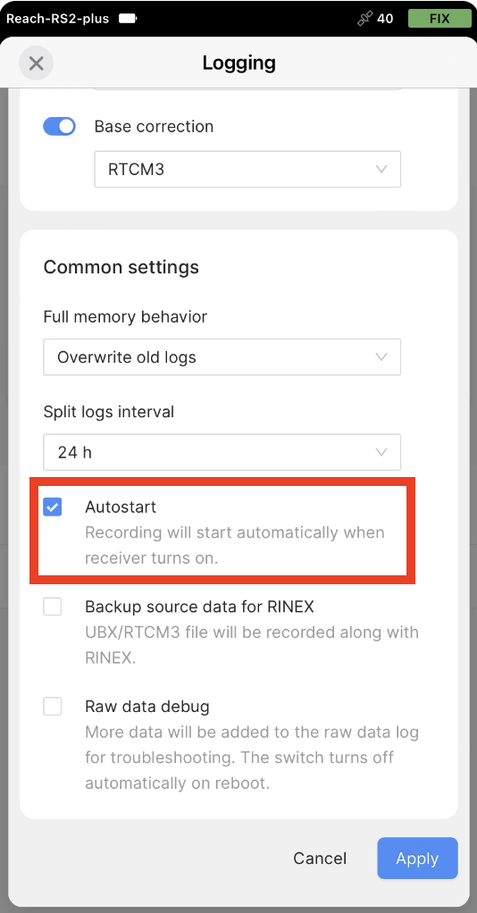
By default, Reach starts recording the logs after it’s turned on. You can check whether this option is enabled in Emlid Flow under Logging → Recorded logs and settings → Settings.
1 Like
@kornel.nemeti is correct in the time observation, i.e. there’s a limit to the accuracy gained versus time on station. But how are you going to verify the point if you only have 10-30 opochs of observation data.
PP has saved my ass many a time and one requirement to PP is enough data. If it’s an important point, you need to log enough data for PP.
There’s no defined time length, however 10 minutes @10 hz would give you enough data for PP… IF you have short baselines to PP. This is why I always have another base on the project site logging data @5 hz or better if using any kind of RTN or even radio RTK.
In post processing, the more time collected on a point the better.
2 Likes
Hello Kornel,
Below is the link for the raw data and CORS data.
NTRIP information:
Address: 40.121.5.206, Port: 10000, Mount point: MSM4_NEAR
Hi Jinwen,
I can’t access the folders for now, but I have requested it. Can you please confirm? Thanks!
Jinwen,
Thank you for sharing your data! Please give me some time to check it, and I’ll share my findings afterwards.
Hi Jinwen,
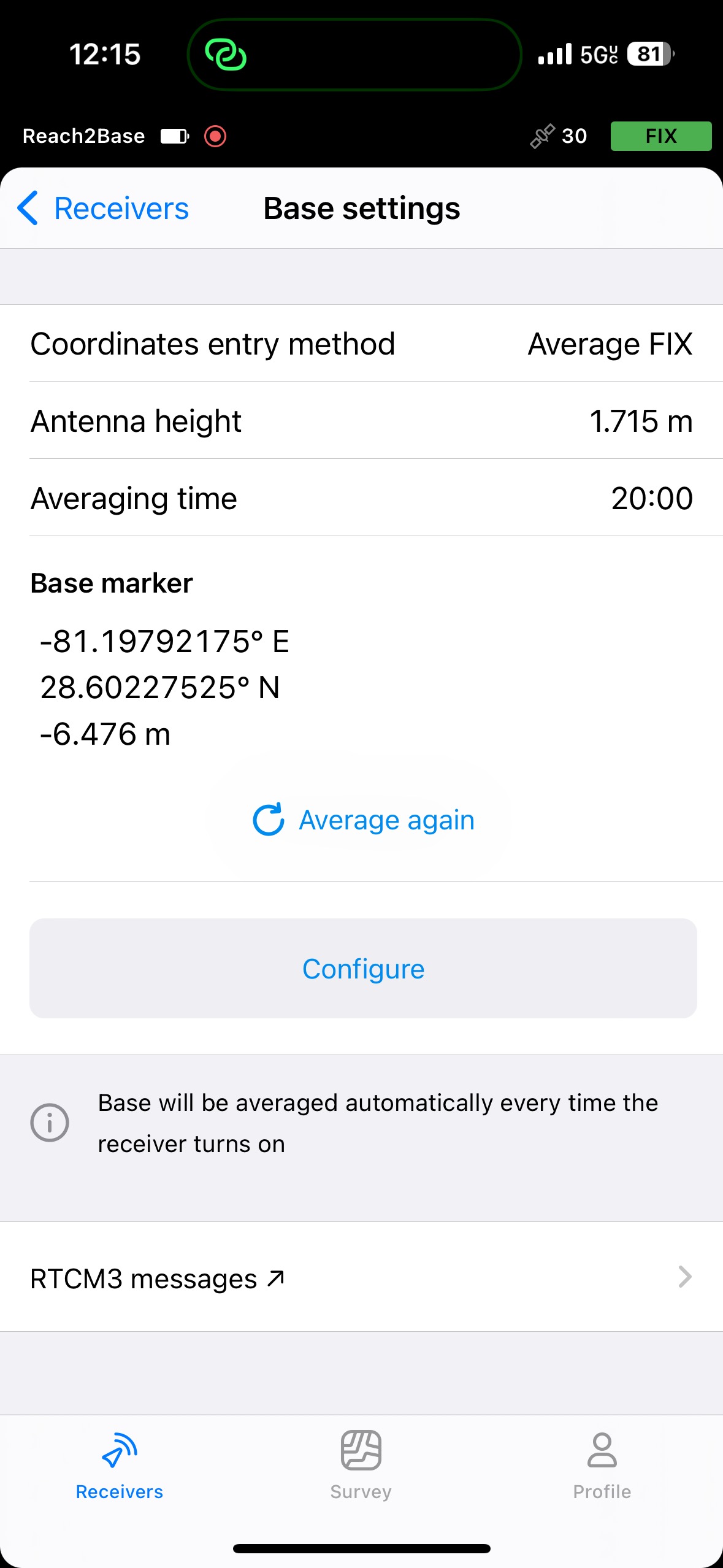
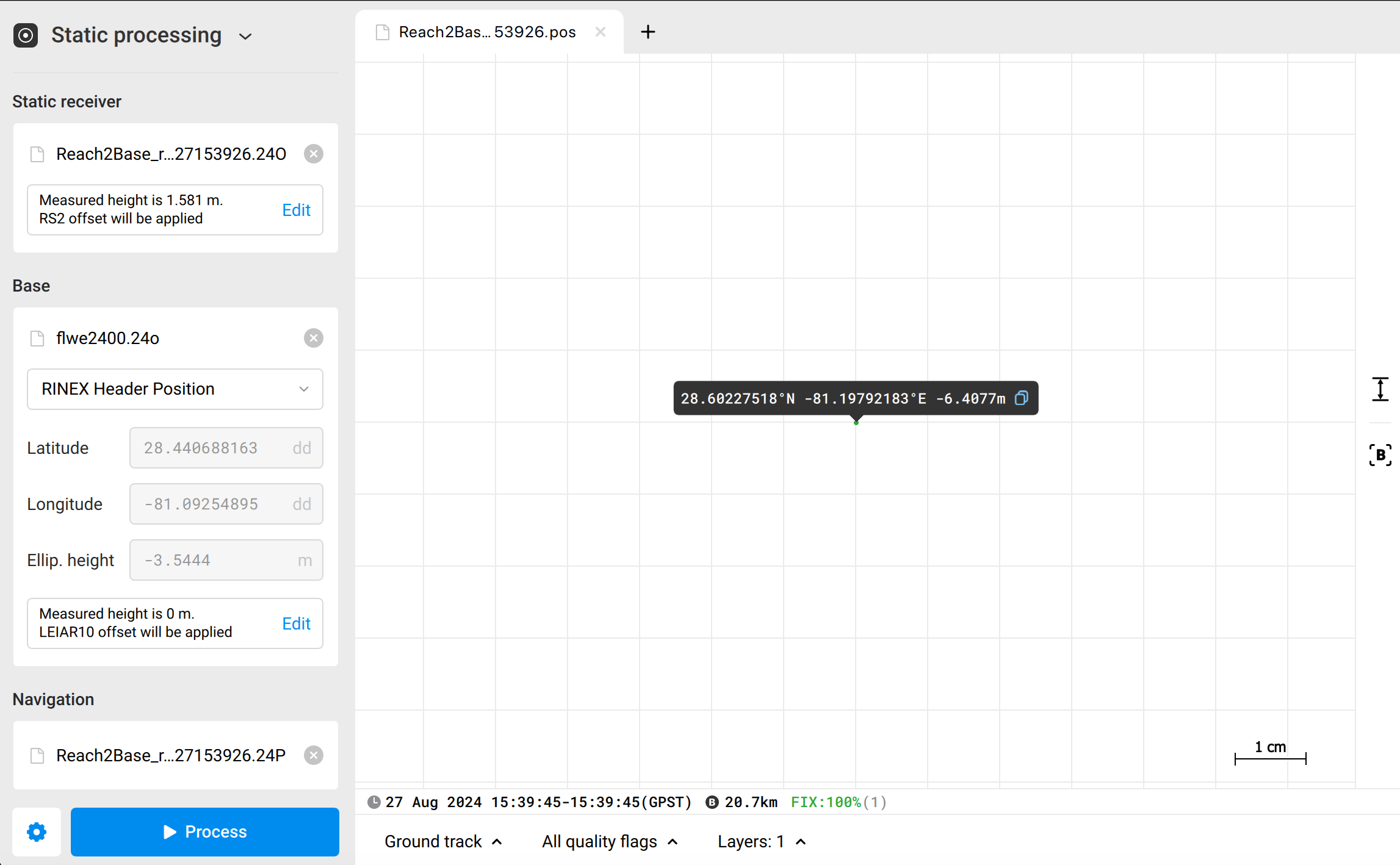
I’ve checked your data and also post-processed it. I noticed on your screenshot from Emlid Studio that you used a measured height of 1.448 for the Static processing, while under the averaged FIX position, the antenna height is 1.715.
This means that the measured height is 1.715 - 0.134 (the antenna offset of Reach RS2) = 1.581 m. Performing the Static processing with this measured height, the elevation is -6.4077 m, which is inside tolerance.
Hi Kornel,
Thank you for the clarification!
But shouldn’t the post-processed coordinates all match the coordinates that we configured on site? They are still a few millimeters off.
Hi Jinwen,
The technology’s limitation regarding accuracy is a few centimetres. So, a difference of millimetres or centimetres between the coordinates of the same point is normal. I recommend using short baselines and recording the logs for a few hours to get the most reliable solution from static processing.
But even with these, such differences can occur, and you can definitely apply these coordinates to set up your base manually.
1 Like
I see. Thank you so much for the answer!
1 Like
Hello Kornel,
I have a few more questions:
- If we want to get a fixed position, how much time should we configure? What is the standard practice in the field? Considering that we’re also doing post-processing on the coordinates.
- When it’s not possible to get a short baseline, how do we reduce the error of the coordinates?
Hi Jinwen,
If the environmental conditions are good, averaging the points for 1-2 minutes should be enough to obtain accurate results in PPK. Please note that a longer averaging time will not necessarily increase the accuracy of the result.
In such cases, I recommend recording the raw data logs longer to do the PPK. However, please make sure that the receiver has an open, clear sky view during the entire recording.
2 Likes
Thank you so much for your reply!
1 Like
This topic was automatically closed 100 days after the last reply. New replies are no longer allowed.