


I am thinking of buying an RS2. I would like to know if exporting from ReachView, in csv or other format, also provides information on PDOP. I have installed ReachView 3 but the output of the demo survey does not provide this data.
Thanks
| Name | Easting | Northing | Elevation | Description | Easting RMS | Northing RMS | Elevation RMS | Lateral RMS | Antenna height | Solution status | Averaging start | Averaging end | Samples | Base easting | Base northing | Base elevation | Baseline |
|---|---|---|---|---|---|---|---|---|---|---|---|---|---|---|---|---|---|
| 1 | 1665929.547 | 501980.82 | 1373.085 | 5.5 | 0.033 | 0.033 | 0.078 | 0.047 | 7.001 | FIX | 11/6/2020 13:05 | 11/6/2020 13:05 | 10 | 1665713.468 | 501531.154 | 1435.739 | 502.039 |
Thanks for the example!
So, the PDOP doesn’t appear.
Maybe this feature will be available in the future?
That would be nice, or even better RDOP: RDOP - a very nice way to judge precision in an RTK setup
1 Like
I see. Maybe both? 
I said PDOP because the software I use for surveys ask this parameter.
Indeed
PDOP is a good indicative for very short observations (30 secs or less) on short baselines. RDOP would still be a better indicator though, as it also factors in observation time and baseline length.
Javad has implemented some form of RDOP in their field software J-Field. In the settings profile for different kinds of collection methods, “confidence” and “consistency” levels are set by the user and used in the the time collection based on movement of the GNSS constellations. This verifies a position collected and is re-verified after a certain number of epochs set by the user, all RTK engines (6) are reset and then the new position is compared to the number of collected positions obtained during the first verification. If positions collected in the 1st verification agree with the second set of verification, then the position is stored for the point.
In the 4 years our firm have used Javad equipment, we’ve never had a bad shot in high multi-path areas.
Emlid could learn a lot from their methodology.
1 Like
Hi guys,
Thanks for your suggestions! We’ll consider the possibility of adding it.
3 Likes
Hi @studioBroggi,
Could you please clarify what software do you use?
The software is “Pregeo”
https://www.agenziaentrate.gov.it/portale/web/guest/schede/fabbricatiterreni/aggiornamento-catasto-terreni-pregeo/software-pregeo-intermediari
used by the Italian land registry for updating the cartography. These are the forms for collecting the baseline start and end points (XYZ for the base and DX, DY, DZ for the end point)
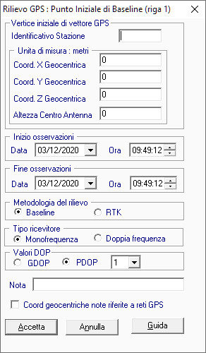
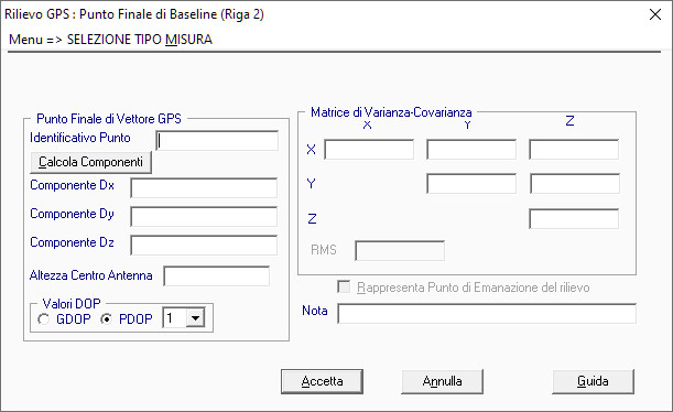
They also ask for information on the variance / covariance matrix which usually, in the case of local surveys with baseline <5000 km, uses values at 0.000
actually a bit wierd that you have to input PDOP in a form that at the same time allows you put 24h obs time… PDOP will change quite a bit over 24h, especially in non-optimal conditions.
1 Like
I understand that they want to know the PDOP for each point I collect in the survey. The start and end time in the first form means: “from this base point, with this coords, this PDOP, I have collected points during this interval” (1, 2, 3 hours …). Then I use the second form to communicate the measurements of each collected point.
This topic was automatically closed 100 days after the last reply. New replies are no longer allowed.