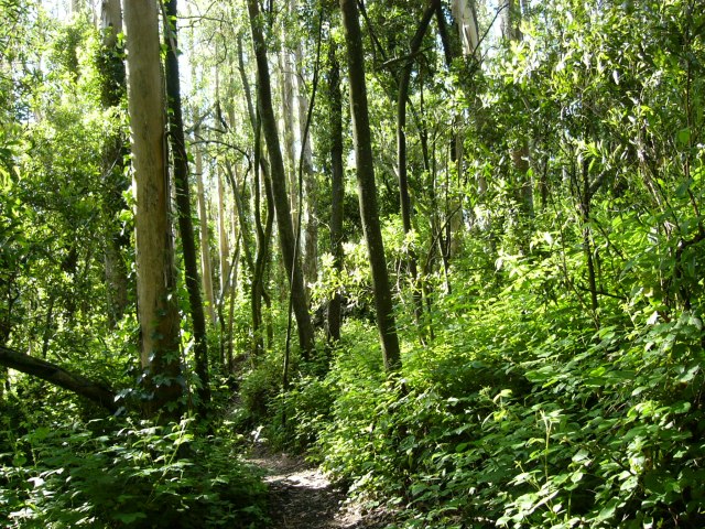
Hello everyone. I have an RS2 antenna, and I would like to know or understand if by using NTRIP instead of LORA, I can improve my reception under the trees. Any other recommendations to improve reception under thick trees?
If you are under trees, satellite view will be obstructed no matter what you use. Ntrip and lora are 2 different ways to transmit your base correction to your rover. often i found that lora works great in open fields but not so much in urban areas or dense vegetation (max 300m in my experience). therefore, if your job site has a lot of obstruccions, but good cellphone coverage, i would use Ntrip.
If your working under trees, ill use pos-processing (stop and go) and even then you may not be able to get fix.
Now, maybe your working tolerances allow you to work with “float” measurements, usually between 15 and 30 cm of error.
For high accuracy under trees, ill look for a spot with clear sky to measure a couple of points and then use a total station.
of course, thinking in the worst case scenario for a survey. your site my be diferent.
this is what i think for a bad place to survey.
Hi Jaime,
I agree with Diego. We don’t recommend using our receivers in conditions where the devices don’t have an open, clear sky view. They’ll have quite limited satellite visibility, which will lead to an inaccurate position calculation. Also, while surveying under trees, obtaining a FIX solution can’t be guaranteed.
Of course, it depends on the particular environmental conditions. Is there a chance you can share a photo of your survey location?
I also agree with @Diego_a and @kornel.nemeti , observations in areas like this with RTK or RTN is basically a waste of time… unless you have Javad receivers like we do.
You can do static observations with an additional two receivers on-site also logging data. The key here is planning for optimum satellite geometry with low PDOP and long occupation times. I’ve done this a few times with my RS2 and M2 in areas as shown in the picture. I did a 1 hour observation at the rover and had two other receivers onsite. Baselines were approx 1 km between the rover and the other two receivers. After post processing and adjustment of the GNSS traverse loops, the positional error of the rover point was <5cm in both horizontal/vertical components. Javad Justin post processing software was used in the reduction of the data. We verified the position using our Javad Triumph LS+ and accuracy was the same. Using the Javad , verification took less than 5 minutes.
You can use Emlids in wooded areas however static observations are the only method to use and with verification of the derived solution. Short baselines and closed GNSS/terrestrial traverse loops are required.
RTK with Emlid’s are a “no-no” in wooded areas.
One little detail I would add is that if you are in a part of the world where there are seasons and the tree cover is deciduous, you could wait until fall or winter when leaves are absent from the tree canopy.
i will said not just for emlid pretty much for all GNSS, wooded areas are a big “no-no”. Except maybe for next gen or high end antennas.
We’ve used our Javad’s for the last 10 years in high multi path areas all the time. Doing mostly boundary survey work and control networks they have paid for themselves many times over. They are the best land surveyor’s scientific GNSS signal analyser ever made.
Too expensive for most. But yes, if your making that kind of cash, these things pay for themselves.
Personally, if i was gonna continually hock my house over my lifetime, it would be Trimble or Leica and that’s it. Even if Javad is techically best. The tech will get knocked offed eventually if not already.
Sure hope the next model of Emlid catches up with the rest.
I.e.
TRUE multi-band, not just L1, L2 & E5. But at least L5 and further if feasible for better canopy / multipath work. Algorithms that prevent False Fixes and spoofing.
Higher powered Tx/Rx UHF / VHF / LoRa radios.
Hot swappable dual batteries.
Higher Update Rate like Mosaic X5.
Laser single point EDM (Time of Flight (ToF) distancing… better yet, full on LiDAR point cloud scanning.
Dual cameras for staking and AR.
Hybrid GNSS and IMU computing when GNSS is limited or non-existent or to help IMU computing and/or eliminate drift.
Higher durability to prevent dome/shell cracking, not to mention the silicone cover problems.
Did i leave anything out ![]()
I know there are products out there that aleady do all of this… but Emlid should have a better pricepoint along with their established Emlid Ecosystem of course which no other has. ![]()
I hope Emlid Dev team is paying close attention to this here comment ![]()
This topic was automatically closed 99 days after the last reply. New replies are no longer allowed.


