Reading the docs, it says that when using an RS2 as a rover receiving corrections via NTRIP, that the CRS should be set to the same as the NTRIP base. Being a nube, it is not clear to me what CRS the base is using. Can one of you experienced folks kindly share your thoughts on the following base please.
This is in Washington state, USA.
At the bottom, it cites a IGS08 reference frame. Should I set the CRS to NAD83/2011 with elipsoid height or leave in WGS84, which I think Emlid is now just calling “Global”.
I can share what I’ve found regarding this. It’s a bit hard for me to check it out fully, though. Not a user-friendly interface out there
I’ve seen this USGS’s website where I’m pretty sure the ITRF2014 system is stated for the coordinates. This means that if you insert these coordinates to the ReachView 3’s Base mode on the base, you can further choose any ITRF2014-based system in the projects on the rover.
Still, this is somewhat my assumption. So it’d be great to reach out to the station’s support to know for sure. I guess they can give you a more developed review of it.
Also, a few words about Global CS. This is just an option for you to work with geographical coordinates in ReachView 3 in the project on the rover. So, it can be any geographical system, WGS84 or NAD83. In case of using it, you will get the same coordinate system on the rover as you inserted on the base.
On the base, you can insert only geographical coordinates for now. You don’t choose any specific system, you can just enter them by choosing the Manual method. That’s how it is at the moment.
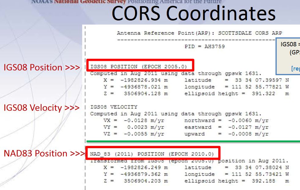
I’m still trying to figure out if there is a meaningful difference (for cm accuracy) between this and NAD83(2011)? This slide from the linked pdf seems to indicate a substantial difference.
I have not opened RV3 to see if IGS08 is available.
In this scenario, I am going to set up on a known monument. I am going to receive corrections via NTRIP from a station with a baseline of less than 10km. The NTRIP station is using IGS08
The purpose of this test is to compare the corrected coordinates as determined by the RS2 with the published coordinates of the monument.
What should I enter into the project settings for the coordinate system?
The attached pdf is the documentation for the monument.
It took me some time to take a closer look at your case. I’ll share some findings I have.
Yes, they differ quite a bit. Mainly because the NAD83 system is specific to America while IGS08 is a worldwide system. I believe they can be pretty close in values somewhere, however, we should not take it for granted.
So this is an interesting topic. You can work in ReachViews 3 with a Global CS system option. Basically, it stands for any CS that provides you with geographical coordinates. So you can just go to the app and choose the Global CS option in your project’s Coordinate System.
So, if your base provides you its position in IGS08, you will have IGS08 in your rover’s coordinates. Your marker’s coordinates are in NAD83(2011). So, you will have different coordinates for sure. To compare them, you will need to convert one into the other.
The transformation between these two systems is time-dependent, so it requires 14 parameters including the date of point collection. In ReachView 3, for now we support 7-parameters transformations only. So here, I suggest going for the additional surveying software that can help you to convert them. I believe QGIS should be able to handle this.
In the US, you would enter the NAD83 2011 coordinates in LAT/LONG. The vast majority of VRS networks or single base connections are broadcasting and logging in NAD83 2011. I would just match apples to apples and stick to the markers coordinates in lat/long.
Also it’s kind of strange that the ntrip provider is broadcasting using IGS08 and all NGS passive stations are like “Coyote” NAD83/2011 datum. Is this a state/federal agency or private ntrip ? Are you sure they are providing data based on IGS08 ? Is this a UNAVCO ntrip ?
Our state RTN is based on the NGS CORS (NAD83/2011) and broadcasts on this datum.
I’d try just using the Washington State Plane North projection per the data sheet and find other passive stations nearby to check also. If they don’t check, I don’t know what you can do other than find another RTN.
Hi Bryan. You nailed it. This is the UNAVCO network. The commercial providers, including WSRN are too costly for the amount of work I’m doing. I’ve been just leaving the RS2 set to global (geographic). I have not been back to Coyote or another monument to see how it compares to what the RS2 is saying.
I’ve said this before, our SC Geodetic Survey maintains our RTN VRS. It’s very reasonable @ $50/month, $600/year. Minimal downtime for software/firmware updates.
Try contacting state (highway depts)/county agencies and local surveyors, they may have knowledge of cheaper RTN’s or may have their own that could be accessible.
You may even try local short line railways. We did a lot of work for our local railway (60 miles) starting in the late 90’s and ending about 6 years ago when they were sold. My dad had suggested to them about establishing a local network for realtime tracking of their rolling stock. They were real interested, but the cost of creating the then 2G and newer 3G network in the early 2000’s was too prohibitive. We even had ALLTEL biting at the bit just to get involved. There was no cellular network to speak of in this area then. Mainly just around local metropolitan areas like Charlotte and Columbia.
If nothing else, get another receiver and use EMLID’S caster if you have cellular coverage. Or you could even PP.
Since you are familiar with unavco, is leaving the RS2 on Global the appropriate setting when receiving corrections? The NGS conversion tool doesn’t convert between NAD83 and WGS84, correct?
Since I am not a surveyor, I am basically using control to make my data as accurate as possible. But when I work on a project that requires reference to a CRS, typically a state plane, I work off of control set by a surveyor.
WSRN starts at $1900 annual. SmartNet is $1800 annual.
I just wanted to circle back on this thread and finish it off.
Today, I went by the benchmark (Coyote) and set up the RS2 as precisely as my non-calibrated vial would allow.
In RV3, I set the project to Global CS and I collected a point on the monument by averaging / fix only, for 5 minutes. The baseline to NTRIP station was 5 km. The point recorded in RV3 states a PDOP of 1.4.
As stated above, the NTRIP caster is referencing IGS08. From everything I have looked at, it seems that IGS08 (which is basically the same as ITRF08 and ITRF2014) can be considered identical to WGS84 at the centimeter level.
Back at the office, I used an online converter to transform the Coyote stated coordinate to IGS08 reference frame and compared the coordinate to the coordinate collected by the RS2.
The difference was as follows.
Lat: 2.6 cm
Lon: .96 cm
height: .3 cm
The meta on the monument states that the coordinate is accurate to 2cm horizontal and 5cm vertical. So, I missed the horizontal slightly but pretty much nailed the height. Maybe I could get closer with a more precise vial on the pole. But overall, I think it is a decent test result.