Not getting accurate survey results (Reach RS+)

Hello all,

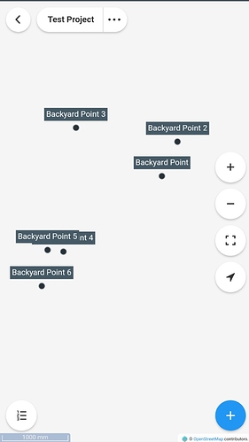
For strictly testing purposes, I have placed my Reach in two different physical positions, collecting 3 data points each. For some reason, all the points seemed to be in different places, and I was getting a huge sigma value. Is there a way I can get this to be more accurate?

Backyard Point 1-3 are at one physical locaiton, and 4-6 are at the other. They were about 6 feet apart.

Receive corrections and run RTK. Those are probably single solutions.

4 Likes

You are going to have to provide much more details for any sort of good help. (1) with NTRIP or (2) Reach RS+?

See the DOCS about creating system reports etc.

1 Like

Agree.

Hi @mazzo,

To achieve centimeter-level accuracy GNSS receiver needs to get corrections from a base with the known position. Usually, two receivers are used (base and rover). One Reach in single mode can achieve only a few meters accuracy.

Probably correction transmitting isn’t configured correctly. Could you please share screenshots of your “Base mode” tab of the base unit and “Correction input” tab of the rover one?

1 Like

What approximate accuracy will the RS+ receive when the base is not in a known position?

2 Likes

It’s all relative to whatever location the base thinks it is.

1 Like

But it’ll be ~2.5m if there isn’t a known position, right? Placing the base | Reach RS/RS+

We do a lot of work in the bush or even in agricultural fields without a known position (or where I assume there is not a known position). New concept to me with GPS.

Hi Brians,
You can find the answer of your question here : Highest accuracy in Africa - no cors networks - #2 by Luke_Wijnberg

Depends on your application but the question is whether you need to meet absolute and relative accuracy requirements.

If you need absolute accuracy then you would have to PPK your base position and Rover to a reference station nearest to region.

If relative is all required then you simply would have to survey with your base station coordinate averaging for x number of minutes, longer the better to get perhaps better absolute accuracy too. But you would then send corrections from base to rover of which would be RTK and results be accurate relatively. If you need to return to same area of survey, simply put base in same position as before and use same base station coordinate logged in previous session. You are now relatively accurate between survey days as base is same.

4 Likes

What’s the error in the relative measurement working in this way on the X, Y and above all on the Z axis?

Is this error the same for RS (one band) and RS + (multiband)?

I assume you meant the new RS2 as (multiband) and both the RS and RS+ are BOTH (single L1 band).

Yes :wink:

1 Like

Here’s a quick scenario if you have (2) Reach RS or RS+ using LoRa (you can do the same with M+ if you also obtain the LoRa module option for each M+).

Set (1) Reach RS/RS+ as the BASE on a known point (either from a public record or one by a surveyor). I.e. you have the coordinates and the ellipsoid height which you manually enter in base mode in ReachView. (Also your antenna height (ground point up to bottom of receiver plus 65mm)) The accuracy will be as good as it will get in this case for the BASE portion.

Now when you use the other RS/RS+ as your ROVER via LoRa, you will get cm accuracy between the BASE and ROVER.

Now let’s say you do NOT have a KNOWN POINT. Like @RTK_Hunter mentioned, do you need ABSOLUTE accuracy as the scenario above, or do you just need RELATIVE accuracy which is next without a known point to set base on.

For relative accuracy (in relation to the BASE). You would basically be creating your OWN “personal” known point for your base you could revisit later for your cm accurate ROVER to work from. It’s (the base location) nothing accurate in surveyor’s terms but accurate enough for you locally and your project between base and rover.

So what happens here when working relatively, is the base has to approximate best it can by itself first, “autonomously” or AVERAGE SINGLE mode for a few to several minutes. Now, this will only be accurate to about 2.5m. The coordinates and ellipsoid height it derives “best it can autonomously” will NOT be cm accurate but meter accurate bouncing around in a 2.5m or so area, not within a cm accurate area. The BASE ONLY. Mark the point below the base physically to revisit / set base on later. Make a note of the coordinates and ellipsoid and manually save them in the base mode settings. Note the antenna height will be 0 doing this. (Antenna height (ground to bottom of receiver plus 65mm) only comes into place when you use a known published or surveyor point).

Now here is the good part i think your concerned about. While the ROVER is receiving corrections from the BASE relatively, you will have cm accuracy between the BASE and ROVER. The baseline is the distance between them. Now if clear sky view etc, FIXED solution, and lets say you placed the base and rover for testing 5m exactly apart, your baseline will reflect that within cm accuracy.

Keep in mind that your base is still sitting somewhere within 2.5m accuracy though, not exactly on a published or surveyed point, so all your grouped cm accurate points collected (between base and rover only) will be offset or shifted in relation to the base. If later you obtain an accurate known point if you needed absolute accuracy, you can shift them later or correct them in cad software etc. But as @RTK_Hunter mentioned, that is the question, do you need your final work to be absolute or will relative suffice?

Either way, you will have cm accuracy between base and rover. You will have this also if based on absolute known published/surveyor point. You will have cm accuracy if the base derived it’s own coordinates autonomously (average single within 2.5m), BUT the rover will be offsetted or shifted relative.

If you use only (1) RS/RS+ you will only get 2.5m accuracy (unless you use NTRIP to a CORS station which is like using someone else’s base and now your base becomes the rover for cm accuracy via RTK)

Once you add that 2nd Reach RS/RS+ as a ROVER, then you get cm accuracy via RTK.

Keep in mind that the new RS2 will help here when in area that has foliage etc where the single L1 frequency Reach RS/RS+ will lose FIX quickly. Personally i feel these are only good in open clear skyview working environments… how often is that… so the RS2 is the best choice for serious work now that it is a reality. I.e. purchase (2) using LoRa or (1) using NTRIP CORS (as long as a CORS station within max range and you have internet access via cell etc) for cm accuracy. Best choice for more options (2) RS2.

4 Likes

Well put. Solution.

1 Like

In my case I continue to be torn between a single-band receiver and a multi-band receiver… as the price difference is large…

I always work outdoors… I don’t do surveys in the city… I don’t do surveys in places with high vegetation… but I often do surveys inside open pit… often the depth of these open pits is also 100 m below ground level and the walls and the bottom are in white stone (highly reflective)…

In my mind you might as well consider yourself in a suburban environment, potentially even worse, because no signal will penetrate the sides.
Also, moving closer to the walls could introduce quite a bit of multipathing.

Depending on the size of the pit a multifrequency GNSS solution like the RS2 will give you acceptable performance, but if narrow, a total-station is probably a better solution.

4 Likes

The station can always be placed in a position with the entire sky, at 360 degrees, completely free.

Yes. The rover may need to measure points close to the walls. Usually the open pit is not closed on 4 sides, at least 1 is totally open. Usually the upper mouth is, at least, 150-200 meters wide.

Doing tests with the simple GPS of the mobile phone, even in the worst situations, however 12-15 satellites are always seen.

Nevertheless the multipath always remains a source of error because the reflected signal travels farther to reach the antenna, the reflected signal arrives at the receiver slightly delayed. This delayed signal can cause the receiver to calculate an incorrect position.

I understand that a multi-frequency receiver solves this problem. Correct ?