


A little update.
Using all the information here, I flew for an hour, taking +800 photos.
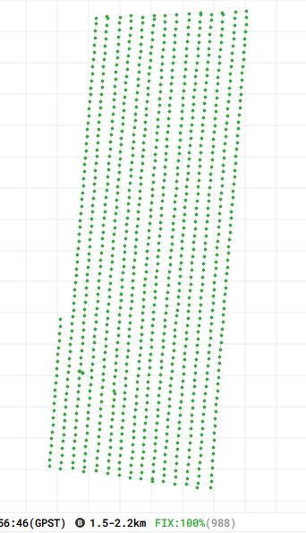
100% fix after removing two photos from the .event log (battery starts).
Perfect.
Unfortunately, none of the photos were accepted by Dronedeploy. The are working on it now
When this is done, I’ll write a case study to save people all the questions again
6 Likes
I am sure this can help you to have power continuity in Mettatec PPK kit.
https://mettatec.com/producto/ppk-phantom-battery-add-on/
Hi geo Henry
I have that, its great, the Battery keeps the gnss unit on so you don’t have multiple log files or waiting on boot up again.
Unfortunately, i don’t think it keeps the drone on during a battery change, which is what I mentioned earlier. (I might be wrong though, it would be great if the drone stayed on while changing batteries, no waiting for boot up)
1 Like
Hi Joe,
Thank you for your patience. I have some feedback from our Engineering team about the Emlid re-processed imagery. Their updates are below:
We ran an investigation into the EXIF data on the images. We noticed the images you have provided there is very little EXIF data compared to a sample set of successful images (screenshot below).
DroneDeploy Images:

Your images:

Here is an additional update about the different EXIF data:

It seems these images are missing an important part of the EXIF data we require for upload. We have created a larger Engineering ticket to help us prioritize supporting this type of EXIF data in the future. We have also reached out to Emlid to see if they could add these fields to their pre-processing algorithm. Unfortunately, I do not have a timeline for this fix but I’m happy to keep you in the loop with any updates that arise in the coming weeks.
Does anyone else use dronedeploy here and ppk? If like to see if it is just me
Not using DroneDeploy, but I’d be happy to see if Exif loads in Metashape.
1 Like
That would be great! The photos with the updated metadata are below.
@wizprod Any chance you have had a look?
Not yet, downloading now.
Can you give me an example of correct and incorrect lat/lon/height for a random image?
Looking at the errors, I’d say metashape are using the original exif data? Up to 18 meters of error.
I am also noticing that the camera-angles are missing from the files it seems?
Here are 10 updated and unmodifed photos
https://1drv.ms/u/s!AutYJ-QZGpnehPgfwGeApeYxze8z1Q?e=2BAkUx
Hi Joe,
Looks like the discussion moved to another thread. Let’s continue collecting all the details there. I’ll close this topic just so that nobody get confused.