After some advice. I have a topo job to do in a rural area with no state benchmarks.
It’s not required to be set up on UTM coordinates so I will most likely set my own benchmarks and create a local system based on GDA2020 and then in future I could just use the benchmarks I created to localise the job if needed to go back.
Does this workflow sound ok to those experienced in similar situations?
I would like it to be set in UTM if possible and I’ll be out there for 6+ hours so was wondering if I should set my Base Station up log while I do the survey. Will that interfere with the base and rover connection? I’m not familiar with PPK at all.
Any advice would be appreciated thanks
That really depends on the goals of your project, but in general I would recommend to establish some benchmarks in the area, log static data on them and process using the awesome AUSPOS service.
This way you will get multiple points to setup your base station on and have all your positions on the rover tied to GDA2020/MGA grid.
I hope that this makes sense, but feel free to ask more questions. You might also consider getting in touch with the team at Mapgear as they will be more knowledgeable in the local specifics.
The goal for the project is just machine control work so it doesn’t need to be tied into GDA2020 however if it was it does make the localization of plans a bit easier.
I’m hoping that I could do the survey with my base and rover so I have RTK connecting and all collected points are relative to the base but have the base logging during the survey so when back in the office I could determine the correct position of the base station then apply the correct error to all the collected points.
Is something Like that possible?
Because what I normally do is set my base up in a random spot but use base shift by collecting a known point with my rover, it then applies the error in real time so surely I could apply an error after the survey using excel?
The Auspos route is likely the best for you if there are no fixed benchmarks in the area. The link for Auspos is:
The emailed results file will be in GDA and local MGA zone but also in ITRF and local UTM so you can pick and choose what you want to use going forward.
It might be worth trying local councils or construction sites etc to see if they have a local benchmark or 6 nearby. If you are way out bush then a mine or forestry type site may have something you can use. But I’m guessing the site is very remote which will be a limiting factor.
For Post processing you can do the shift in excel once you know the difference from local average base position in draft RTK survey. You can also use the stop and go workflow with emlid flow and do the post processing in emlids studio. The docs section and blog style posts on here will keep you right there. That will work with both the dummy RTK method and just logging raw rover in single mode with raw base logs and no RTK. Just for any important higher order observations such as additional benchmarks etc give a good few minutes log to make sure the results are reliable as opposed to the quick capture for basic topo shots.
Hi Jack,
Ignore my original reply as I mistook your location.
If you are in Aus there shouldn’t be any reason not to use GDA2020 and it’s the simplest and straight forward.
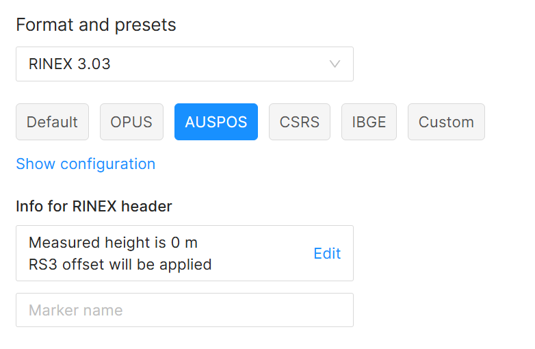
When you set up the base logging you can select the specific AUSPOS option. This screenshot is from the reach panel but the settings are the same and work fine for me for AUSPOS:
While this is good if you only want to run a PPP process, it’s always a good idea to record ALL constellations and a higher refresh rate than might be in the presets. This will enable you to have more data to tweak processing settings if you want to post process rovers against your base for that particular session.
It’s possible to downsample the rinex file sent to Auspos with Emlid Studio anyway if needed.
You can log data on the base and rover simultaneously while doing RTK. It shouldn’t interfere with the base and rover connection.
For this, you can use our Stop&Go workflow. You need to record log data on both the base and the rover. Process the base log data on a PPP service such as AUSPOS, then process it in Emlid Studio using this corrected base position.
Another way to get a benchmark is to use the log from the base and do the PPP. Next time you go back to the field, you can use this benchmark to perform the RTK method.
Thanks for all your replies.
I will use the AUSPOS in future situations now thankyou and will look into it more to become comfortable with it when the time comes
But as Scott suggested it never hurts to ask the question. I asked the client if he had any old survey plans which he didn’t but next door just had work done and was willing to share the benchmarks with me so we were able to tie into the GDA2020 grid really quickly which was the best case scenario!