Here is what I have in that file:
version: teqc 2016Nov7
SV±--------|--------|--------|--------|--------|--------|--------|--------+ SV
1|-_ --_ _-| 1
2| -oooooooooooooooooooo-_ | 2
3|-~-_ _-- | 3
4| ‘’’’’’’’’’ ‘’’’’’’’’’’’’’’’’ | 4
5| -- _=~-_ | 5
6|-~~~~~~~~~~~~~~~~~- ______ | 6
7|~- ___ _-| 7
8|- -~
11|oooo- -oooooooo- _ooooooooooo| 11
12| _-~
13|ooo-_ _ooooooooooooooo- _oooooooo| 13
14| --oooooooooooooooooooo- | 14
15|| 15
16| -oooo– -ooooooooooooooooo- | 16
17|~
18| -ooooooooooooooooooooo- | 18
19|ooooooooooooooooo- -ooo| 19
20| -ooooooooooooooooooo- | 20
21| -ooooooooooooooooooo- _____ | 21
22|-ooooooo- -oooooooooooooooo- _| 22
23| -oo- oooooooooooooooooo- | 23
24|-- -~-
25| -~~~
27| -~2- -~~-_ | 27
28|oooooooooo- _-ooooooooooo| 28
29| _-- _
30|| 30
31| _____ _--_ | 31
32| _--_ | 32
9| _--_ | 9
10| _-
26| _--_ -~~~~~~~~~~~~~~-_ | 26
R 1|_ -*****************- MI1**? |R 1
R 2|–__ 2******************- ???|R 2
R 3| -- **************- |R 3
R 4| -******- 1**************- |R 4
R 5| -*********I 22***********- |R 5
R 6| -:::::::::::- :::::::::::::- |R 6
R 7| -*************- - |R 7
R 8| -****- 1******- |R 8
R 9|****- _-- ***???|R 9
R10|- *******1 ???|R10
R11| _-- *****- -???|R11
R12| -::::::::::- :::::::::::::- |R12
R13| M1******- - |R13
R14| III-11 -- |R14
R15| _-I1 ****************- |R15
R16|- — -M*****************? |R16
R17| -- _- |R17
R18|**- 2*******- ************- |R18
R19|***- I2- -???|R19
R20|******- -M2***- -***???|R20
R21| -2****************- __I- ???|R21
R22| -*****************- _-- |R22
R23| -2*************- :****- |R23
R24| II************II MI**II- |R24
-dn| 11111111 111111111111111 |-dn
+dn|121 1111111 11111123212122221 1111 112111 122221222122222121111 11 1 |+dn
- 5|hkliijjiiiiijjjjiiiklljjijlkjijkkkjjjlllkkjllmkjjjljjkllkjiijjjjjjjijiaa|+ 5
Pos|ooo ooo o |Pos
Clk| |Clk
±--------|--------|--------|--------|--------|--------|--------|--------+
00:00:00.000 23:59:30.000
2017 089 2017 089
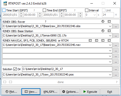
QC of RINEX file(s) : mnav0890.17o
input RnxNAV file(s) : /collector/Brdc/brdc0890.17n
/collector/Brdc/brdc0890.17g
4-character ID : MNAV (# = 9)
Receiver type : TRIMBLE NETR9 (# = 5426R48928) (fw = 4.85)
Antenna type : TRM57971.00 NONE (# = 31052655)
Time of start of window : 2017 089 00:00:00.000
Time of end of window : 2017 089 23:59:30.000
Time line window length : 23.99 hour(s), ticked every 3.0 hour(s)
antenna WGS 84 (xyz) : -254104.7446 -4531622.0505 4466526.1727 (m)
antenna WGS 84 (geo) : N 44 deg 43’ 58.61" W 93 deg 12’ 33.93"
antenna WGS 84 (geo) : 44.732946 deg 266.790575 deg (= -93.209425 deg)
WGS 84 height : 300.8411 m
|qc - header| position : 30.2897 m
Observation interval : 30.0000 seconds
Total satellites w/ obs : 55
NAVSTAR GPS unhealthy SV: 4
NAVSTAR GPS SVs w/o OBS : 4
NAVSTAR GPS SVs w/o NAV :
GLONASS unhealthy SV: 26
GLONASS SVs w/o OBS : 25 26 27
GLONASS SVs w/o NAV :
Rx tracking capability : 44 SVs
Poss. # of obs epochs : 2880
Epochs w/ observations : 2880
Epochs repeated : 0 (0.00%)
Poss win obs > 0.0 deg: 57847
Poss win obs > 5.0 deg: 51045
Possible obs > 0.0 deg: 57847
Possible obs > 5.0 deg: 51045
Complete obs > 5.0 deg: 48812
Deleted obs > 5.0 deg: 2068
Masked obs < 5.0 deg: 1165
Obs w/ SV duplication : 0 (within non-repeated epochs)
Moving average MP12 : 0.553572 m
Moving average MP21 : 0.620603 m
Points in MP moving avg : 50
Mean S1 : 45.10 (sd=4.27 n=50880)
Mean S2 : 39.02 (sd=6.84 n=48812)
No. of Rx clock offsets : 0
Total Rx clock drift : 0.000000 ms
Rate of Rx clock drift : 0.000 ms/hr
Avg time between resets : Inf minute(s)
Freq no. and timecode : 2 13598 ffffff
Report gap > than : 10.00 minute(s)
epochs w/ msec clk slip : 0
other msec mp events : 0 (: 127) {expect ~= 1:50}
IOD signifying a slip : >400.0 cm/minute
IOD slips < 5.0 deg* : 0
IOD slips > 5.0 deg : 35
IOD or MP slips < 5.0*: 0
IOD or MP slips > 5.0 : 45
- or unknown elevation
first epoch last epoch hrs dt #expt #have % mp1 mp2 o/slps
SUM 2017:089 00:00 2017:089 23:59 24.00 30 51045 48812 96 0.55 0.62 1085
SWN 2017:089 00:00 2017:089 23:59 24.00 30 51045 48812 96 0.55 0.62 1085
Processing parameters are:
Receiver tracking capability : 44 SVs
Maximum ionospheric rate (L1) : 400.00 cm/min
Report data gap greater than : 10.00 min
Expected rms of MP12 multipath : 65.00 cm
Expected rms of MP21 multipath : 65.00 cm
Multipath slip sigma threshold : 4.00 sigma
% increase in MP rms for C/A | A/S : 100.00 %
Points in MP moving averages : 50
Minimum signal to noise for L1 : 4
Minimum signal to noise for L2 : 4
Elevation mask (cutoff) : 5.00 degrees
Elevation comparison threshold : 25.00 degrees
Orbit path spline fit sample time : 10 min
SVs w/ code data for position try : 5
Width of ASCII summary plot : 72
Data indicators on summary plot : yes
Do ionospheric observable : yes
Do ionospheric derivative : yes
Do multipath observables : yes
Do 1-ms receiver clock slips : yes
Tolerance for 1-ms clock slips : 1.00e-02 ms
Do receiver LLI slips : yes
Do plot file(s) : no
Observations start : 2017 089 00:00:00.000
Observations end : 2017 089 23:59:30.000
Observation interval : 30.0000 second(s)
SV #+hor #+mask #reprt #compl L1 L2 P1 P2 C1 C2
G01 1165 24.08 1049 26.47 1045 1045 1045 1045 0 1045 1045 1045
G02 901 43.07 848 45.60 846 846 846 846 0 846 846 0
G03 1147 24.70 1027 27.29 1023 1023 1023 1023 0 1023 1023 1023
G05 1042 31.37 860 37.45 857 857 857 857 0 855 857 857
G06 1012 34.69 771 44.78 769 769 769 769 0 769 769 769
G07 944 38.62 810 44.79 808 808 808 808 0 808 808 808
G08 1129 26.71 1000 29.84 995 995 995 995 0 995 995 995
G11 1140 23.50 1010 26.21 1007 1007 1007 1007 0 1007 1007 0
G12 1124 26.74 1003 29.67 999 999 999 999 0 997 999 999
G13 1157 24.47 1041 26.92 1039 1039 1039 1039 0 1039 1039 0
G14 905 42.24 852 44.72 850 850 850 850 0 850 850 0
G15 1089 27.68 943 31.58 939 939 939 939 0 939 939 939
G16 1084 29.63 945 33.61 941 941 941 941 0 941 941 0
G17 906 42.38 852 44.91 850 850 850 850 0 850 850 850
G18 913 43.20 860 45.71 858 858 858 858 0 858 858 0
G19 893 41.21 839 43.70 837 837 837 837 0 837 837 0
G20 871 42.51 815 45.25 814 814 814 814 0 814 814 0
G21 1032 34.36 787 44.32 786 786 786 786 0 786 786 0
G22 1141 25.25 998 28.49 993 993 993 993 0 993 993 0
G23 1053 31.35 866 37.54 864 851 864 851 0 851 864 0
G24 1162 23.27 1044 25.62 1039 1039 1039 1039 0 1039 1039 1039
G25 1158 24.04 1042 26.44 1039 1039 1039 1039 0 1039 1039 1039
G27 1153 24.45 1036 26.93 1032 1032 1032 1032 0 1032 1032 1032
G28 919 42.64 866 45.10 864 864 864 864 0 864 864 0
G29 1096 29.09 958 32.91 955 955 955 955 0 952 955 955
G30 1046 32.17 847 39.09 844 844 844 844 0 844 844 844
G31 1012 34.59 771 44.63 769 769 769 769 0 769 769 769
G32 890 42.13 837 44.64 835 835 835 835 0 835 835 835
G09 1113 26.83 982 30.07 979 979 979 979 0 979 979 979
G10 875 42.29 820 44.96 818 818 818 818 0 818 818 818
G26 1111 27.19 980 30.49 976 976 976 976 0 972 976 976
R01 1034 31.83 912 35.78 908 907 908 907 908 907 908 908
R02 1029 30.82 826 37.69 824 823 824 823 824 823 824 823
R03 1059 30.85 928 34.85 925 925 925 925 925 925 925 925
R04 1088 31.81 979 35.08 977 977 977 977 977 977 977 977
R05 1108 30.87 1010 33.62 1007 1006 1007 1006 1007 1006 1007 1007
R06 1121 29.99 1027 32.51 1026 0 1026 0 1026 0 1026 0
R07 1113 30.73 1018 33.37 1016 1016 1016 1016 1016 1016 1016 1016
R08 1094 31.90 988 35.05 986 986 986 986 986 986 986 986
R09 1131 34.38 994 38.77 991 991 991 991 991 991 991 991
R10 1144 30.65 1034 33.65 1032 1027 1032 1027 1032 1027 1032 1032
R11 1075 25.57 954 28.50 950 950 950 950 950 950 950 950
R12 1033 26.26 939 28.64 936 0 936 0 936 0 936 0
R13 1012 28.74 910 31.68 906 901 906 901 906 901 906 903
R14 992 31.96 870 36.08 863 859 863 859 863 859 863 862
R15 994 31.70 844 36.87 842 840 842 840 842 840 842 841
R16 1111 30.13 925 35.62 917 917 917 917 917 917 917 917
R17 1030 26.69 934 29.17 932 932 932 932 932 932 932 932
R18 1136 25.23 1036 27.42 1034 1034 1034 1034 1034 1034 1034 1034
R19 1142 31.60 1039 34.48 1036 1035 1036 1035 1036 1035 1036 1036
R20 1145 32.02 1026 35.44 1021 1021 1021 1021 1021 1021 1021 1021
R21 1076 29.61 897 35.00 894 893 894 893 894 893 894 894
R22 1000 31.46 829 37.39 826 826 826 826 826 826 826 826
R23 991 32.05 865 36.34 863 862 863 862 863 862 863 862
R24 1006 29.68 902 32.81 898 827 898 827 898 827 898 886
G04 1121 26.29 1000 29.17 0 0 0 0 0 0 0
Obs below mask ( 5.00 deg) : 832
Obs reported w/ code | phase : 51712
Obs deleted (any reason) : 2900
Obs complete : 48812
| G | R |
% Obs above mask w/ no L1 : 0.0 0.0
% Obs above mask w/ no L2 : 0.0 9.1
% Obs above mask w/ no P1 : 100.0 0.0
% Obs above mask w/ no P2 : 0.1 9.1
% Obs above mask w/ no C1 : 0.0 0.0
% Obs above mask w/ no C2 : 37.8 8.8
% Obs above mask w/ low L1 S/N: 0.0 0.0
% Obs above mask w/ low L2 S/N: 8.9 0.6
No. of Rx clock offsets : 0
Total Rx clock drift : 0.000000 ms
Rate of Rx clock drift : 0.000000 ms/hr
elev (deg) tot slps <ION rms, m> 5=% 1|m 15=% 2|m
85 - 90 219 0 0.000000
80 - 85 554 0 0.000000
75 - 80 1344 0 0.000000
70 - 75 1775 0 0.000000
65 - 70 2172 0 0.000000
60 - 65 2531 0 0.000000
55 - 60 2335 0 0.000000
50 - 55 2663 0 0.000000
45 - 50 2737 0 0.000000
40 - 45 2755 0 0.000000
35 - 40 2804 0 0.000000
30 - 35 3424 0 0.000000
25 - 30 3534 0 0.000000
20 - 25 4071 1 0.000000
15 - 20 4729 5 0.000000
10 - 15 5295 14 0.000000
5 - 10 5817 15 0.000000
0 - 5 0 0 0.000000
< 0 832 0 0.000000
MP12 RMS summary (per SV):
slips L1 rx L2 rx slips L1 rx L2 rx
SV obs> 5 # del MP12 rms [m] < 25 < 25 < 25 > 25 > 25 > 25
G01 1045 0 26.59 0.535641 0 0 0 0 0 0
G02 846 0 45.80 0.412454 0 0 0 0 0 0
G03 1023 0 27.46 0.536118 0 0 0 0 0 0
G05 857 0 37.66 0.373209 0 0 0 0 0 0
G06 769 0 44.99 0.345328 0 0 0 0 0 0
G07 808 0 44.98 0.479523 0 0 0 0 0 0
G08 995 0 30.04 0.473159 0 0 0 0 0 0
G11 1007 0 26.32 0.588202 0 0 0 0 0 0
G12 999 0 29.85 0.828618 0 0 0 0 0 0
G13 1039 0 27.02 0.519972 0 0 0 0 0 0
G14 850 0 44.91 0.436254 0 0 0 0 0 0
G15 939 0 31.78 0.502310 0 0 0 0 0 0
G16 941 0 33.81 0.780815 0 0 0 0 0 0
G17 850 0 45.04 0.430651 0 0 0 0 0 0
G18 858 0 45.91 0.420678 0 0 0 0 0 0
G19 837 0 43.87 0.579631 0 0 0 0 0 0
G20 814 0 45.41 0.392076 0 0 0 0 0 0
G21 786 0 44.48 0.471991 0 0 0 0 0 0
G22 993 0 28.69 0.694034 0 0 0 0 0 0
G23 864 13 38.20 0.524173 0 0 0 0 0 0
G24 1039 0 25.80 0.553639 0 0 0 0 0 0
G25 1039 0 26.58 0.723025 0 0 0 0 0 0
G27 1032 0 27.10 0.508973 0 0 0 0 0 0
G28 864 0 45.21 0.399316 0 0 0 0 0 0
G29 955 0 33.09 0.437829 0 0 0 0 0 0
G30 844 0 39.26 0.525937 0 0 0 0 0 0
G31 769 0 44.85 0.363818 0 0 0 0 0 0
G32 835 0 44.84 0.379434 0 0 0 0 0 0
G09 979 0 30.24 0.620779 0 0 0 0 0 0
G10 818 0 45.16 0.455661 0 0 0 0 0 0
G26 976 0 30.68 0.618479 0 0 0 0 0 0
R01 908 1 36.04 0.576209 4 0 0 0 0 0
R02 824 1 37.91 0.458653 0 0 0 0 0 0
R03 925 0 35.04 0.601860 0 0 0 0 0 0
R04 977 0 35.23 0.594740 1 0 0 0 0 0
R05 1007 1 33.82 0.571957 2 1 1 0 0 0
R07 1016 0 33.51 0.705263 0 0 0 0 0 0
R08 986 0 35.20 0.673022 3 0 0 0 0 0
R09 991 0 38.88 0.493066 0 0 0 0 0 0
R10 1032 5 33.90 0.527033 1 0 0 0 0 0
R11 950 0 28.69 0.517276 0 0 0 0 0 0
R13 906 5 32.02 0.678155 2 0 0 0 0 0
R14 863 4 36.54 0.580944 8 0 0 0 0 0
R15 842 2 37.11 0.469163 3 0 0 0 0 0
R16 917 0 35.95 0.489787 1 1 1 0 0 0
R17 932 0 29.31 0.667596 0 0 0 0 0 0
R18 1034 0 27.52 0.492668 0 0 0 0 0 0
R19 1036 1 34.60 0.658220 2 0 0 0 0 0
R20 1021 0 35.64 0.570773 1 0 0 0 0 0
R21 894 1 35.22 0.594660 1 0 0 0 0 0
R22 826 0 37.61 0.480590 0 0 0 0 0 0
R23 863 1 36.55 0.525303 0 0 0 0 0 0
R24 898 71 35.08 1.282903 21 4 4 0 0 0
mean MP12 rms : 0.553568 m
total mean elevation : 35.31 degrees
MP12 obs > 5 : 48812
qc MP12 slips < 25 : 50
Rvr L1 slips < 25 : 6
Rvr L2 slips < 25 : 6
qc MP12 slips > 25 : 0
Rvr L1 slips > 25 : 0
Rvr L2 slips > 25 : 0
elev (deg) tot slps <MP12 rms, m> 5=% 1|m 15=% 2|m
85 - 90 219 0 0.260999 |||||
80 - 85 554 0 0.272516 |||||
75 - 80 1344 0 0.295076 ||||||
70 - 75 1775 0 0.370909 |||||||
65 - 70 2172 0 0.347582 |||||||
60 - 65 2531 0 0.365835 |||||||
55 - 60 2335 0 0.368566 |||||||
50 - 55 2663 0 0.367040 |||||||
45 - 50 2737 0 0.387136 ||||||||
40 - 45 2755 0 0.403904 ||||||||
35 - 40 2804 0 0.440185 |||||||||
30 - 35 3424 0 0.446065 |||||||||
25 - 30 3534 0 0.513058 ||||||||||
20 - 25 4071 1 0.659862 |||||||||||||
15 - 20 4729 4 0.683721 ||||||||||||||
10 - 15 5295 18 0.742829 |||||||||||||||
5 - 10 5817 27 0.874269 |||||||||||||||||
0 - 5 0 0 0.000000
< 0 832 0 0.510598 ||||||||||
MP21 RMS summary (per SV):
slips L1 rx L2 rx slips L1 rx L2 rx
SV obs> 5 # del MP21 rms [m] < 25 < 25 < 25 > 25 > 25 > 25
G01 1045 0 26.59 0.597022 0 0 0 0 0 0
G02 846 0 45.80 0.515845 0 0 0 0 0 0
G03 1023 0 27.46 0.642907 0 0 0 0 0 0
G05 857 0 37.66 0.471531 0 0 0 0 0 0
G06 769 0 44.99 0.412774 0 0 0 0 0 0
G07 808 0 44.98 0.521889 0 0 0 0 0 0
G08 995 0 30.04 0.653942 0 0 0 0 0 0
G11 1007 0 26.32 0.724604 0 0 0 0 0 0
G12 999 0 29.85 0.554379 0 0 0 0 0 0
G13 1039 0 27.02 0.740542 0 0 0 0 0 0
G14 850 0 44.91 0.511243 0 0 0 0 0 0
G15 939 0 31.78 0.528072 0 0 0 0 0 0
G16 941 0 33.81 0.595442 0 0 0 0 0 0
G17 850 0 45.04 0.988642 0 0 0 0 0 0
G18 858 0 45.91 0.500353 0 0 0 0 0 0
G19 837 0 43.87 0.588256 0 0 0 0 0 0
G20 814 0 45.41 0.560862 0 0 0 0 0 0
G21 786 0 44.48 0.534793 0 0 0 0 0 0
G22 993 0 28.69 0.772818 0 0 0 0 0 0
G23 864 13 38.20 0.619058 0 0 0 0 0 0
G24 1039 0 25.80 0.616727 0 0 0 0 0 0
G25 1039 0 26.58 0.739773 0 0 0 0 0 0
G27 1032 0 27.10 0.819633 2 0 0 0 0 0
G28 864 0 45.21 0.476010 0 0 0 0 0 0
G29 955 0 33.09 0.538267 0 0 0 0 0 0
G30 844 0 39.26 0.531468 0 0 0 0 0 0
G31 769 0 44.85 0.414339 0 0 0 0 0 0
G32 835 0 44.84 0.611375 0 0 0 0 0 0
G09 979 0 30.24 0.835508 0 0 0 0 0 0
G10 818 0 45.16 0.565002 0 0 0 0 0 0
G26 976 0 30.68 0.689073 0 0 0 0 0 0
R01 908 1 36.04 0.689151 2 0 0 0 0 0
R02 824 1 37.91 0.695022 1 0 0 0 0 0
R03 925 0 35.04 0.530075 0 0 0 0 0 0
R04 977 0 35.23 0.554336 0 0 0 0 0 0
R05 1007 1 33.82 0.570960 4 1 0 0 0 0
R07 1016 0 33.51 0.655049 0 0 0 0 0 0
R08 986 0 35.20 0.658097 4 0 0 0 0 0
R09 991 0 38.88 0.469147 0 0 0 0 0 0
R10 1032 5 33.90 0.573993 0 0 0 0 0 0
R11 950 0 28.69 0.692668 0 0 0 0 0 0
R13 906 5 32.02 0.673212 1 0 0 0 0 0
R14 863 4 36.54 0.613027 5 0 0 0 0 0
R15 842 2 37.11 0.603178 2 0 0 0 0 0
R16 917 0 35.95 0.553560 1 1 0 0 0 0
R17 932 0 29.31 0.656229 0 0 0 0 0 0
R18 1034 0 27.52 0.614361 3 0 0 0 0 0
R19 1036 1 34.60 0.664197 4 0 0 0 0 0
R20 1021 0 35.64 0.773858 2 0 0 0 0 0
R21 894 1 35.22 0.637163 3 0 0 0 0 0
R22 826 0 37.61 0.502466 0 0 0 0 0 0
R23 863 1 36.55 0.651231 1 0 0 0 0 0
R24 898 71 35.08 0.780698 40 4 0 0 0 0
mean MP21 rms : 0.620599 m
total mean elevation : 35.31 degrees
MP21 obs > 5 : 48812
qc MP21 slips < 25 : 75
Rvr L1 slips < 25 : 6
Rvr L2 slips < 25 : 0
qc MP21 slips > 25 : 0
Rvr L1 slips > 25 : 0
Rvr L2 slips > 25 : 0
elev (deg) tot slps <MP21 rms, m> 5=% 1|m 15=% 2|m
85 - 90 219 0 0.265265 |||||
80 - 85 554 0 0.263452 |||||
75 - 80 1344 0 0.301175 ||||||
70 - 75 1775 0 0.348418 |||||||
65 - 70 2172 0 0.323252 ||||||
60 - 65 2531 0 0.306753 ||||||
55 - 60 2335 0 0.352540 |||||||
50 - 55 2663 0 0.397337 ||||||||
45 - 50 2737 0 0.428980 |||||||||
40 - 45 2755 0 0.422630 ||||||||
35 - 40 2804 0 0.461721 |||||||||
30 - 35 3424 0 0.512287 ||||||||||
25 - 30 3534 0 0.616537 ||||||||||||
20 - 25 4071 1 0.802983 ||||||||||||||||
15 - 20 4729 14 0.858117 |||||||||||||||||
10 - 15 5295 26 0.866375 |||||||||||||||||
5 - 10 5817 34 0.827840 #||||||||||||||||
0 - 5 0 0 0.000000
< 0 832 2 0.626566 |||||||||||||
S/N L1 summary (per elevation bin):
elev (deg) tot SN1 sig mean 2|0 4|0 6|0 8|0
85 - 90 219 4.422 48.567 ##||||||||||||||||||||||
80 - 85 556 3.317 48.534 ##||||||||||||||||||||||
75 - 80 1345 2.741 49.149 #||||||||||||||||||||||||
70 - 75 1775 2.866 48.555 #|||||||||||||||||||||||
65 - 70 2172 2.457 49.092 #||||||||||||||||||||||||
60 - 65 2531 2.407 49.133 #||||||||||||||||||||||||
55 - 60 2335 2.360 49.200 #||||||||||||||||||||||||
50 - 55 2845 2.126 48.919 #|||||||||||||||||||||||
45 - 50 2982 2.153 48.584 #|||||||||||||||||||||||
40 - 45 2920 2.194 47.976 #|||||||||||||||||||||||
35 - 40 3059 2.131 47.174 #|||||||||||||||||||||||
30 - 35 3637 2.208 46.013 #||||||||||||||||||||||
25 - 30 3724 2.147 44.789 #|||||||||||||||||||||
20 - 25 4255 2.403 43.489 #|||||||||||||||||||||
15 - 20 4915 2.389 42.167 #||||||||||||||||||||
10 - 15 5493 2.642 40.653 #|||||||||||||||||||
5 - 10 6117 2.800 39.237 #|||||||||||||||||||
0 - 5 0 0.000 0.000
< 0 832 3.647 45.039 ##|||||||||||||||||||||
S/N L2 summary (per elevation bin):
elev (deg) tot SN2 sig mean 2|0 4|0 6|0 8|0
85 - 90 219 4.280 45.983 ##|||||||||||||||||||||
80 - 85 556 4.147 44.523 ##||||||||||||||||||||
75 - 80 1345 4.165 44.074 ##||||||||||||||||||||
70 - 75 1775 3.679 43.732 ##||||||||||||||||||||
65 - 70 2172 3.489 44.526 ##||||||||||||||||||||
60 - 65 2531 3.393 44.343 ##||||||||||||||||||||
55 - 60 2335 3.515 43.684 ##||||||||||||||||||||
50 - 55 2665 3.882 43.005 ##||||||||||||||||||||
45 - 50 2738 4.038 42.622 ##|||||||||||||||||||
40 - 45 2756 4.318 41.954 ##|||||||||||||||||||
35 - 40 2805 4.580 40.950 ##||||||||||||||||||
30 - 35 3427 4.747 40.133 ##||||||||||||||||||
25 - 30 3535 5.619 38.493 ###||||||||||||||||
20 - 25 4072 6.067 36.893 ###|||||||||||||||
15 - 20 4730 6.612 35.184 ###|||||||||||||||
10 - 15 5296 6.818 33.752 ###||||||||||||||
5 - 10 5855 7.008 32.495 ####||||||||||||
0 - 5 0 0.000 0.000
< 0 832 4.140 41.563 ##|||||||||||||||||||


 ot for more help. Thanks very much !