Need help making sense

Hi, I have been using Reach RS, RS+, RS2 and M+ for sometime. We have about 15 units now. Primarily we do photogrammetry and surveying. Typical settings for survey:
SNR:35 ELM:20 GLONASS & GPS only at 5Hz.

Both of our driven rovers, and survey units have had little to no issues, and give us good results. I decided, since we post process our driven logs, to try and post process our survey logs as well. I made a small arduino board, with a button to allow logging points for 1.5 min (30 seconds hold to stabilize the signal, and 1 min of continuous point logging) I then post process the logs, and get my solutions. I checked several locations and it seemed to be doing fairly well.

The reason I did this, was because we had a project where cell reception, and lora would be spotty. Lots of ups and downs, with major tree coverage. We did our logs, and had limited time on the island due to tide scheduling and costs. When we got back I post processed the logs, and have absolutely awful results. I realize it is my fault, and should have grabbed longer logs, or maybe the tree coverage was too bad. I tried to PPP the logs through nrcan.gc.ca with similarly poor results.

Can someone take a look at the logs and see if they can suggest something? I’m all out of ideas.

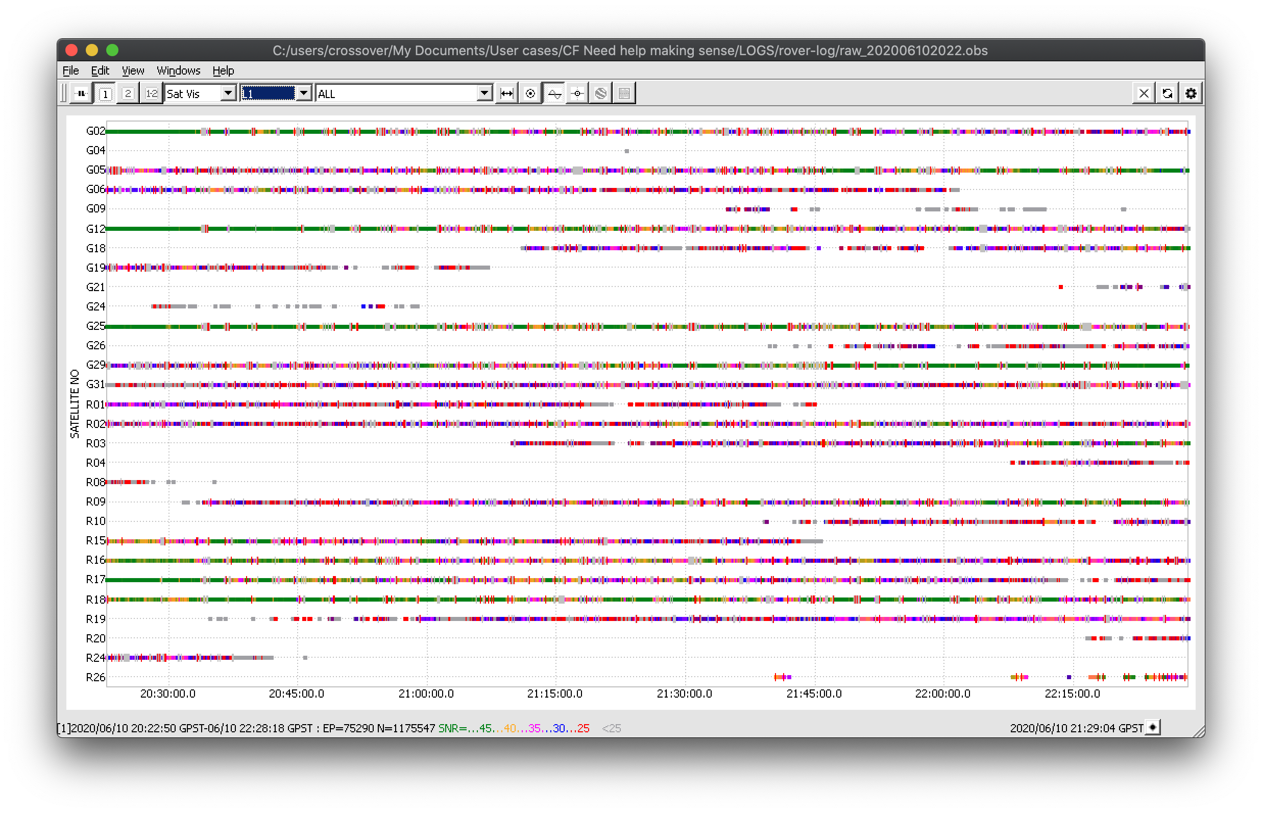
Day1 remote base log (static 49.1354526683, -123.816312154, -5.184)
[near rover, but near trees and obstacles]

Day1 office base log (static 49.20061693055556, -123.05765997777777, -8.237)
[far, but good sky visibility]

Day1 rover log (kinematic)

https://drive.google.com/drive/folders/1xqL6C-eRc8IBrrzBOQz7inoVDKUZ7fhF?usp=sharing

Thank you anyone in advance.

Hi Grigori,

I’ve looked into your data.

I can say that the observational quality of the rover log is rather poor. I’ll attach the screenshot below so that it’s visible.

You can see that the log is full of cycle slips and SNR mainly doesn’t exceed 35 for the majority of the satellites. This usually happens when the placement conditions are difficult for the receiver. Could you please send photos of the environment you surveyed in?

I have post-processed your data with the base logs you’ve shared. I’m afraid the results I was able to achieve contain mostly the Float solution. Please note that the log from the remote base also has a lot of cycle slips but the SNR is much better than for the rover.

To be able to determine the point location with PPP service, I believe you need to record logs for a much longer time. Also, I think you have to consider improving the receiver placement as at the moment, observational data visibly suffers from the environmental conditions.

Also, it’s a good practice to check the GNSS satellites’ availability at the time and place of your survey. You can use various tool for it, for example, GNSS Planning tool or GNSS Radar.

Thanks for the reply and the GNSS planning tools. I rushed the idea of Post Processing, without too much thought. We will most likely return to get better quality points.

Environment is tree covered island.

If you post processed, and got some solutions (float for us is ok at this point), do you mind sharing them, so I can compare? Thanks.

Hi Grigori,

Sorry for the delayed response!

I’ve post-processed your data with 76.2% of Float solution. I’ve sent the configuration file to your PM.

Have you had a chance to come back for obtaining the results with better observational quality? Was it possible to obtain better post-processing results or to use the PPP service?

Thanks Polina,

we ended up going out there again, and gathering a lot more date for each location. It ended up giving us acceptable results.

Thank you for your help.

1 Like

Grigori,

Thanks for the update!

This topic was automatically closed 100 days after the last reply. New replies are no longer allowed.