


anybody that can share vrs information from Missouri DOT VRS? I have username and password, but have found little information on how to connect to the network itself.
Any help will be greatly appreciated.
Jon
anybody that can share vrs information from Missouri DOT VRS? I have username and password, but have found little information on how to connect to the network itself.
Any help will be greatly appreciated.
Jon
found it!
Thanks…
Hi Jon,
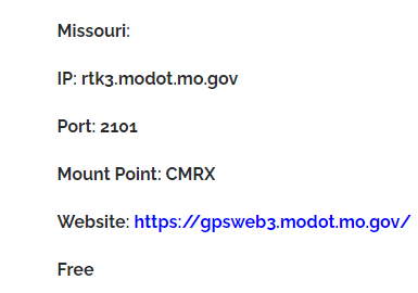
The mount point name sounds like it transmits data in CMR format. It’s a proprietary one and not supported by Reach. You need mount point which sends RTCM3.
Also, to work with VRS, don’t forget to enable Send receiver’s position to the provider option in NTRIP profile settings in ReachView 3. The full guide about working with NTRIP service is here.
Svetlana, thanks for getting back to me. Yes CMR plus is a Trimble proprietary message. I found the ip address on a Trimble vendor website. Just copied and pasted in my comment and didn’t put a whole lot of thought on the content of it. I am currently using RTCM3 and connected.
Thanks again
Jon
Great! Just decided to tell about that to prevent possible issues.
Glad you got it working. CMR(+) is a standard. Topcon uses it as well. It’s just Trimble tries to be the Apple of the GNSS world and like to make their “CMR” which it’s technically not and make it proprietary.
This topic was automatically closed 100 days after the last reply. New replies are no longer allowed.