


Mastering Ground Control Points: Strategies for Optimal Placement of GCPs
1. Introduction
Accurate geospatial data is the backbone of countless applications, from urban planning to environmental monitoring. However, the quality of such data depends heavily on the tools and methodologies used during its collection. Ground Control Points (GCPs) are one such tool that stands out for their critical importance in ensuring precision and reliability.
GCPs act as fixed reference points that anchor spatial data to real-world coordinates, enabling accurate georeferencing and alignment of datasets. Their significance extends across a wide range of fields, including topographic surveys, construction site management, precision agriculture, and disaster response planning. Without well-placed GCPs, even the most advanced mapping systems can yield outputs with distortions and inaccuracies.
By integrating GCPs into geospatial workflows, professionals can achieve unparalleled levels of accuracy, reducing errors and enhancing the credibility of their projects. Whether it’s creating a detailed 3D model of a construction site or mapping large agricultural fields, the strategic use of GCPs is a game-changer. This article delves into how to effectively place GCPs to maximize their benefits and ensure the highest quality results. In figure 1 can see a project area and GCP positions.
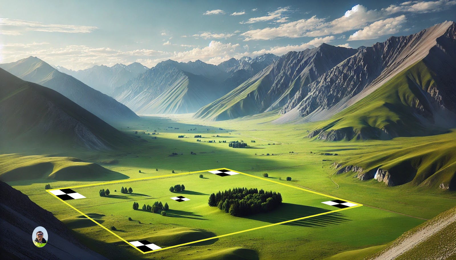
Figure.1: Shows a project area and GCP positions.
2. What Are Ground Control Points?
Ground Control Points (GCPs) are precisely marked locations on the Earth’s surface with known coordinates, which serve as reference points for geospatial data collection and analysis. These coordinates are typically measured using highly accurate surveying equipment such as GNSS (Global Navigation Satellite System) devices. GCPs act as anchors that align and georeference spatial data, ensuring that the collected data corresponds accurately to real-world locations.
GCPs are indispensable in a variety of fields due to their ability to enhance the accuracy and reliability of spatial datasets. Some key applications include:
- Topographic Surveys: GCPs provide a framework for creating detailed and accurate maps of terrain, essential for infrastructure planning and land management.
- Construction Projects: In construction, GCPs ensure that site surveys and 3D models align with design specifications, reducing errors and improving project outcomes.
- Environmental Studies: Researchers use GCPs to monitor changes in ecosystems, track erosion, and study climate impacts with high precision.
By offering a foundation for accurate spatial data, GCPs enable professionals in these fields to make informed decisions, optimize workflows, and achieve superior results.
3. Why GCP Placement Matters
Proper placement of Ground Control Points (GCPs) is a fundamental aspect of achieving reliable and accurate geospatial data. The strategic positioning of GCPs ensures that spatial datasets are aligned correctly, minimizing errors and maximizing efficiency during data collection and processing. Here are the key benefits of proper GCP placement:
A) Improved Accuracy
The primary purpose of GCPs is to enhance the accuracy of geospatial data by providing a reliable framework for georeferencing. Properly placed GCPs ensure that every point in the dataset corresponds precisely to its real-world location, significantly reducing positional errors. This level of accuracy is essential for projects that demand high precision, such as infrastructure development and cadastral mapping.
B) Reduced Distortion
Improperly distributed GCPs can lead to distortions in the final dataset, especially in areas far from control points. By placing GCPs strategically across the entire project area—including the edges and areas of varying terrain—you can ensure uniform accuracy and minimize distortions. This is particularly crucial in large-scale mapping projects or regions with complex topography.
C) Efficient Data Processing
Well-placed GCPs streamline the data processing workflow, reducing the need for extensive manual adjustments and corrections. This not only saves time but also ensures that the outputs are consistent and reliable. Efficient processing is especially valuable in projects with tight deadlines or those requiring the integration of multiple datasets.
By understanding and implementing proper GCP placement strategies, geospatial professionals can unlock the full potential of their data collection efforts.
4. Key Strategies for Optimal GCP Placement
A) Spread GCPs Evenly Across the Area
Uniform distribution of GCPs across the project area is crucial. Ensure that they cover the entire extent, including the edges, to minimize errors in areas far from the center.
Tip: Place at least one GCP at each corner of the project boundary and a few within the interior.
B) Use a Triangular or Cross Pattern
When possible, arrange GCPs in triangular or cross-shaped patterns. This geometry enhances spatial accuracy and prevents distortions in the dataset.
Example: For rectangular sites, a cross pattern with points at the center and corners works well.
C) Account for Terrain Variability
In areas with significant elevation changes, distribute GCPs at various heights. This approach ensures that elevation data remains accurate and reduces errors in 3D models.
Pro Tip: Place GCPs at both the highest and lowest points of the terrain.
D) Ensure Visibility from the Air
GCPs must be clearly visible in aerial imagery. Use high-contrast materials like painted targets, tarps, or checkerboard markers to enhance visibility.
Tip: Position GCPs away from obstructions like trees, shadows, or reflective surfaces.
E) Maintain Consistent Spacing
The spacing between GCPs should reflect the scale and resolution of your project. For high-resolution surveys, place GCPs closer together; for larger, low-resolution projects, wider spacing may suffice.
Rule of Thumb: For drone surveys, a spacing of 100–200 meters is often ideal.
F) Include Check Points
In addition to GCPs, designate a few points as check points to validate the accuracy of your results. These points should be measured but not used in the processing.
Best Practice: Use 10–20% of your total points as check points.
G) Secure and Mark GCPs Properly
GCPs should be physically stable and clearly marked to ensure consistent data collection. Document their locations with GPS coordinates and photographs for easy identification during processing.
5. Common Mistakes to Avoid
- Clustered Placement of GCPs
Placing too many GCPs in a single area while leaving other parts of the project sparsely covered can lead to uneven accuracy. This clustering creates regions with high precision but leaves other areas prone to significant errors. To avoid this, ensure a uniform distribution of GCPs across the entire project area. - Neglecting Edge Coverage
The edges of a project area are often the most vulnerable to distortion, especially in large-scale surveys. Failing to place GCPs at the boundaries can result in warped datasets and unreliable outputs. Always include GCPs at the edges and corners of the project to maintain uniform accuracy. - Ignoring Accessibility
GCPs should be placed in locations that are safe and accessible for surveyors to measure and maintain. Placing GCPs in hard-to-reach areas, such as dense vegetation or steep slopes, can complicate data collection and compromise the accuracy of measurements. Prioritize locations that are both visible and easily reachable. - Overlooking Quality Control
Neglecting to validate the accuracy of GCP coordinates can undermine the entire dataset. Errors in GCP measurements can propagate through the geospatial data, leading to inaccuracies in the final results. Always verify the accuracy of GCPs before integrating them into the workflow, and use check points to cross-validate the results.
By being aware of these common mistakes and actively working to avoid them, professionals can ensure the effective use of GCPs in their geospatial projects.
6. Tools for Efficient GCP Placement
GNSS Devices and RTK
Accurate coordinate collection is essential for GCP placement, and GNSS devices, particularly those with RTK (Real-Time Kinematic) capabilities, are the go-to tools for this task. These devices deliver centimeter-level precision, ensuring each GCP is accurately recorded in real-time for seamless integration into photogrammetry workflows.
Mapping Software
Specialized mapping software allows users to design and visualize GCP distribution patterns. These tools can simulate the impact of different placements, helping to optimize the layout for accuracy and efficiency.
7. Conclusion
Strategic placement of Ground Control Points is fundamental to the success of geospatial projects. Properly distributed GCPs ensure accurate, reliable, and distortion-free mapping, which is critical for applications ranging from construction to environmental studies. By implementing best practices, avoiding common mistakes, and leveraging advanced tools like GNSS with RTK devices, drones, and mapping software, professionals can significantly enhance the quality of their geospatial data. Embracing these strategies not only improves project outcomes but also establishes a strong foundation for future mapping endeavors. Accuracy starts with GCPs—place them wisely for results you can trust.