I find this very confusing because I have no formal training in surveying.
I have two RS2 units, one for base and rover. I’m using the Emlid Flow app on Android.
I have created a project in Georgia West (ftUS) EPSG 6447 in my Rover and I’ve used Manual to use a known point to set the base location. (I’ve done this in both the Base and the Rover, not sure if that is necessary). I get the message to make sure my base is in NAD83(2011). I do not know how to do this and it’s driving me crazy. I’ve searched online for hours and can’t find an answer. Can anyone help me here?
This is the line from the instructions online that I’m trying to comply with: After setting up coordinate system for your project on the rover, make sure to specify the same datum as on the base while configuring rover’s coordinate system in the survey project.
If your known point coordinate for your base is referenced to Georgia West (ftUS) EPSG 6447. Then your rover will be referencing the same coordinate system.
If you have created a project and set the coordinate system to Georgia West (ftUS) EPSG 6447. Then when you collect points with your rover, everything should be fine.
Georgia West (ftUS) EPSG 6447 is referenced to NAD83(2011)
So its all automatic if you pick the point from the project? Whatever the project CR is will control everything else? If this is how it works, thats nice and simple.
Whatever coordiante system you setup in the Flow project is what all the hardware is going to report. The the known base point coordinate was derived from the native WGS84/NAD83 projection then everything should match and you should be able to collect points that will be rectified when you open another software using the same CRS and units. Don’t forget to make sure the units USft vs INTft are the same. The same if you are importing data into Flow(360). If it doesn’t align it is usually one or more of the following three things.
Units: USft vs INTft
Scale Factor: Grid (native projection) vs Surface coordinates
Localization
Our project for example was surveyed with our SPCS in USft. The Engineer took that information and set their CAD up to feet (INTft) and applied a scale factor from grid to surface values which moved the CAD 300ft east and 1200ft north of the surveyed control if you reference in at 1:1. When I reverse the scale factor to bring their linework down it is still off 6ft east and 20ft north. That is the amount of the conversion between INTft and USft. They didn’t take that into account when they brought the survey data in to design to and if I hadn’t caught it one of the new buildings would have been 5ft into an adjacent existing building. We won’t even talk about the factor that the Engineer moved the origin point from 0,0 to one of the property corners…
There is no way to specify the datum when setting up the base. So, when you set it up over a known point, you need to ensure that the base coordinates are in NAD83(2011).
(I’ve done this in both the Base and the Rover, not sure if that is necessary)
You do not need to set up the coordinates for your rover. It will compute its position relative to your base.
All the coordinates are always based on a datum. It helps define where points are located. The same location in the WGS84 datum can have different coordinates if you use a local datum like NAD83(2011).
So, in Emlid Flow, you need to ensure that the coordinates you set up your base on are in NAD83(2011) if you need your rover’s position in NAD83(2011).
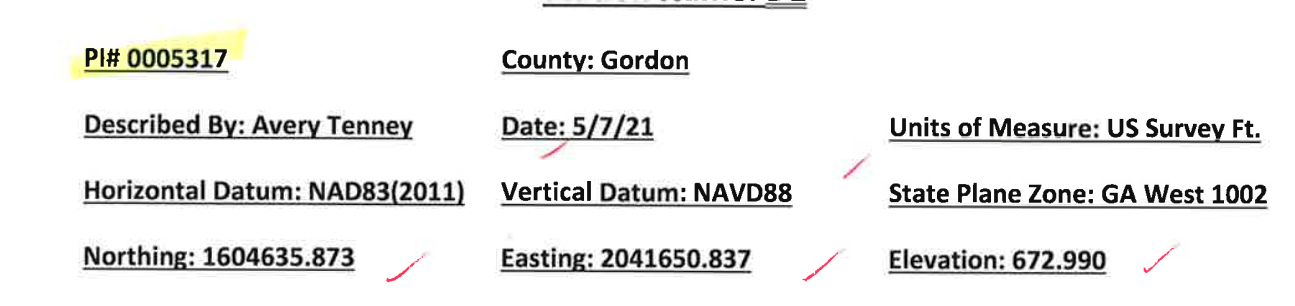
Where did you get these known coordinates from? Do you have the metadata or documentation for these known points?
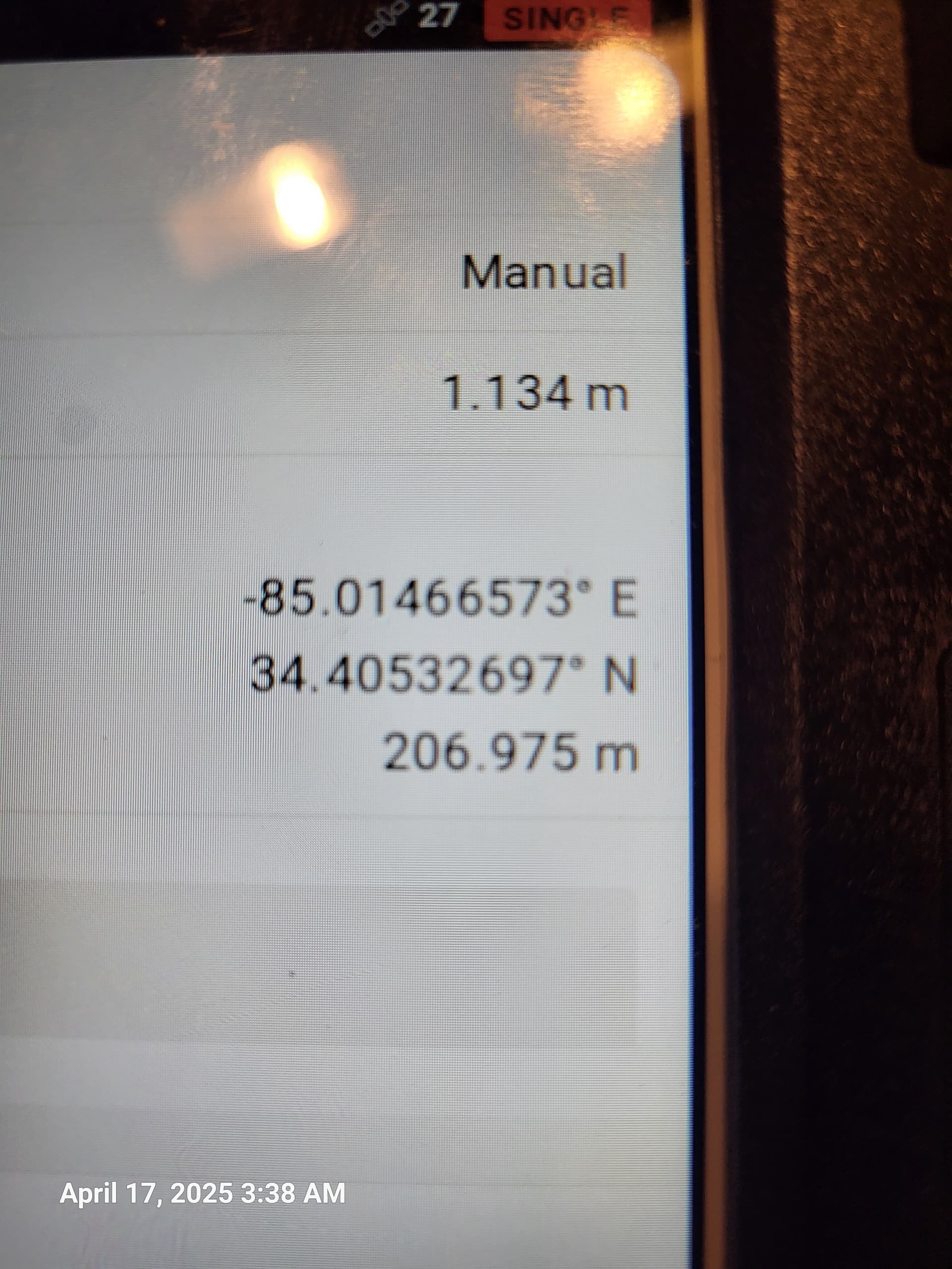
I’m sorry to be so late in responding to your offer of help, had to go out to the field and use the Emlid units. Below is a screnshot that should answer your question.
Then you don’t need to worry at all, as it seems like your known points are based on the NAD83(2011) datum, which is what you need. Your coordinates are local, and Emlid Flow requires the base coordinates in latitude, longitude, and ellipsoid height.
But don’t worry. You can set up your base using the point picker option in Flow. You can read more about it here.