


So I am using an extra M2 that I have with a static gps antenna mounted to the side of my building. I’m collecting it’s known point via a VRS network I pay for as well as against OPUS to determine the most accurate and tightest point. Once I have that, I will then connect the base to the Emlid caster and then in the field use an RS2 via the caster for the corrections. My question is, when using RV3 and I want to use the state plane coordinate system, is the M2 bases point collected in WGS84 or NAD83(2011)? I recall previous topics mentioning that RV3 will only collect via NTRIP based on the system that the base antenna was collected in. Ultimately I want to be able to collect in NAD83(2011) but not certain how to do that when doing a 30 minute base fix collect or when getting that point via OPUS.
I would collect data at the permanent base for at least 4 hours or more depending on baseline lengths to whatever CORS you are using. Then PP using OPUS or use your own software. If you use shorter observation time, you will see errors when checking into passive control marks.
If you use OPUS, check the box for “extended report”. You can then see the rms errors of the baselines used. This will give you an idea of the actual accuracy of the base. You should see less than 2 cm error in the baseline lengths. The rms values shown in the final computed position from OPUS in the “short” report can be misleading unless you look at the baseline rms errors.
This should “automatically” put your points in right systems, given that service is using the system you need ?
If your base is in NAD2011, your rover will be as well. However, the vertical component should always be supplied in ellipsoid.
With the above described flow, you should be able to get the whole thing in RV3.
However, you have a potentially big error source in your own derived base-point. You need to be absolutely sure you have the right coordinate down to the millimeter almost.
When you say is in NAD2011, do you mean as a setting somewhere in the software or physically sitting in that specific region of the planet on the side of my building?
When using RV3 via the NTRIP connection it’s telling me my PDOP is 1 and estimated Accuracy is 1.4cm Horizontal and 9.9mm Vertical.
Nope to both. The systems are basically using different offsets from WGS84. When inputting a base in your local system, this offset is included in your coordinates, and will also be applied when you enter your coordinates in your base.
Yep, at that given time. For a permanent base like yours, I would gather 1-2 days of data of process it. It is sitting there anyway, why not get the most precise base-coordinate?
So let it sit for 1 to 2 days and then run the 30 minute collect or run 1 or 2 days of RINEX and process via OPUS?
Run for 1-2 days of Rinex, and then Process that as static.
Hi Seth,
If your VRS network sends correction in NAD83(2011), you can create a project in ReachView 3 in NAD83(2011) and collect a point in NAD83(2011). You can then enter these coordinates in ReachView 2 base mode tab and use your Reach M2 as a permanent base station.
Using OPUS to establish coordinates is a good idea as well. You can do both methods, compare accuracy, and choose the best result.
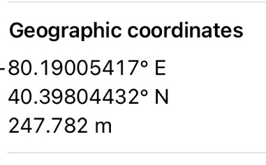
So I set my project to NAD83(2011) Pennsylvania South. Looking at the collected point there is the Coordinates and RMS as well as the Geographic Coordinates. I’m assuming I would enter in the geographic coordinates into the base section?
Also what coordinate system is this in?
Are you referring to decimal degrees instead of minutes/seconds/degrees?
I’m not certain. I’m trying to determine what I should use in the base section after collecting the known point via NTRIP like @svetlana.nikolenko mentioned to do with RV3.
those are LON/LAT and ALT (commonly known as LLH) in decimal degree format.
To enter them, just enter the numbers LAT= 40.39804432 LON= -80.19005417 ALT= 247.782 Make sure the minus sign is in front of the LON or else it makes it a W. As for what system, if I understand it correctly it is whatever system your CORS network is generating NAD83 WGS84 or whatever.
Thanks
Really interested to see how this goes! As you might have seen on another thread I am demo-ing RTKNET’s NTRIP and was thinking about do something similar to what you are doing before I bit the bullet and started paying for RTKNET. The major plus for their service is that my drone duties are starting to take me all over Texas so the self-service would only be good for specific areas. I was going to setup one at my house and one at the office which would capture a decent number of our projects, but where to go from there? I guess I could ask employees if I could set one up at their houses, lol…
Hi Seth,
You’re right. You should enter geographic coordinates as base coordinates.
These geographic coordinates are in NAD83(2011). You use NAD83(2011) Pennsylvania South, based on NAD83(2011).
Once you enter these coordinates as base coordinates, you can continue surveying in NAD83(2011) Pennsylvania South.
Let’s say that within ReachView 2 I ran a 30 minute fix collection under the base mode section. What coordinate system would that be produced under vs doing it as a 5 minute 59 second collect under RV3 as NAD83(2011) PA S Ellipsoid?
Since I used an NAD83(2011) NTRIP, I’m assuming then those coordinates for the 30 minute collect and the 5:59 minute collect will be the same as the NTRIP service.
you would get the same system, however, you would get a more trustworthy position for your base with the the 30 min obs.
Yeah it appears doing the 30 in RV2 also gave me many more decimals at the end then I received in RV3.
I also noticed the decimal degrees supplied by RV2 was also long than supplied by OPUS. I figured using the more finite and longer option from RV2 was better than the OPUS solution.