I am trying to work out a best practice for establishing a base location on an unknown coordinate, and I am using the NR-CAN PPP service for my first set of trials. I let my REACH RS log for 4 hours, and also recorded a number of points with the Reachview App at various intervals during the logging. I hope this will give me an idea of how much more accurate the PPP refined coordinates are.
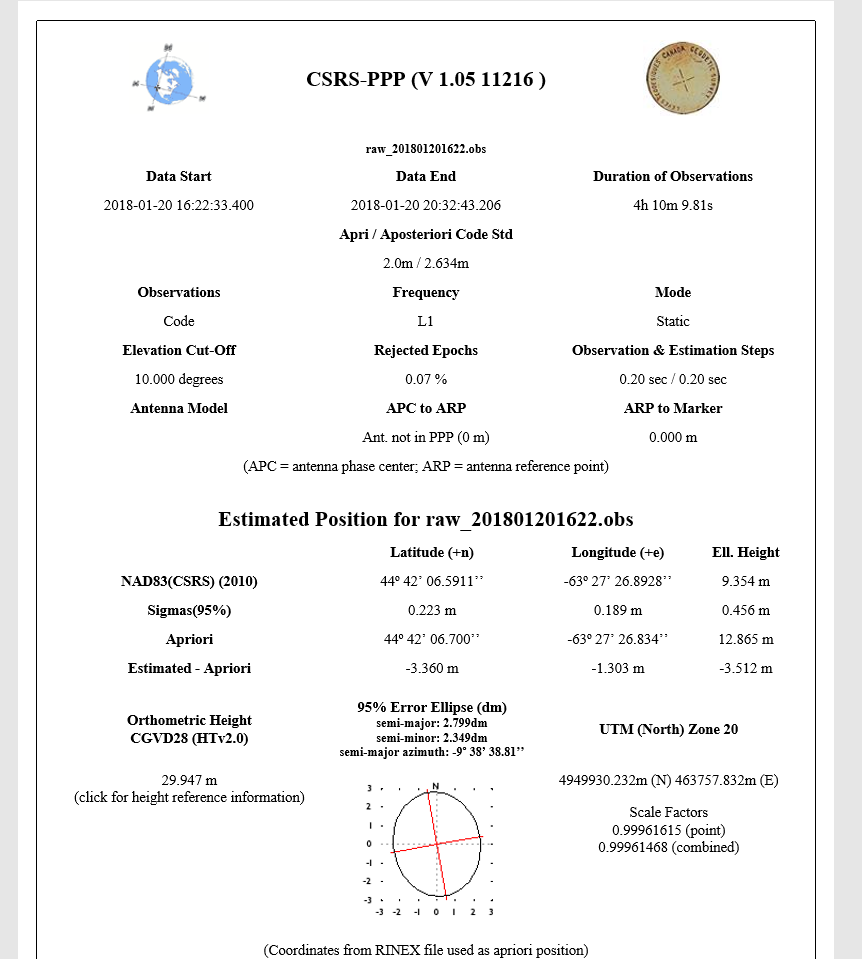
Anyway, I got my results back from NR-Can, and want to make sure I am looking at the right information. It returns coordinates for NAD83(CSRS) (2010) as well as UTM (North) Zone 20 (in Northing and Easting). Are these coordinates equivalent? NAD83 is a datum, and UTM is a coordinate system, correct? Is that to say that in the result these two are linked in both sets of coordinates? And if I convert the lat lon to N and E, I should get the numbers listed in the result?
I have used this service before for comparing coordinates during a course I took, but I am rusty to say the least. The coordinates come back in NAD 83 (CSRS) in lat and lon, whereas the points I recorded in survey mode at WGS84. Ideally, I want both in NAD 83 (CSRS) as easting and northing for easy computation of differences.
When I did something similar in my course, I had the luxury of working with some Leica and Trimble equipment which did a lot of the reprojections, coordinate system changes, and grid shit stuff for me. Now I have open source software I am not all the familiar with. I have been relying on QGIS for coordinate system transformation, but I am not all that sure it is accepting changing WGS84 to UTM with the NAD 83 (CSRS) datum
Can anyone suggest a sure fire way to get these coordinates in the same reference frame for comparison?
Hi,m I might have time to post more about this later, but one question is how accurate do you need a real world position, … NRCAN can’t get very accurate positions for l1 only GPS receiver (like reach) you need a dual frequency for that.
With l1 only and NRCAN ppp – I think your lucky to be less then 0.5m
I set up my Reach base over the same spot on 20 Jan and again on 27 Jan. I sent raw files to NR Can for PPP on both dates to determine the consistency in results. I am not liking what I am seeing, but unsure if it is a limitation of NRCAN processes, maybe poor GNSS Geometry, or the slightly varied logging time (I spent 4 hours on 20 Jan, and only 3 hours and a few minutes on 27 Jan)
Anyway, my Northing is off by 22cm (that is fine, as my tripod rig is not survey grade) but my northing is off by 2.17 meters. If that is the standard I can hope for, using PPP to establish a reliable base location for RTK is not very encouraging. I know logging more time would help absolute accuracy, but I was expecting to see results more closer based on 3-4 hours. (Is that a poor assumption?)
Any tips to get better coordinates if I run this sort of test again? It’s got to be sub-meter for sure, and I am hoping to get below 25cm difference while setting up on the same point.
I would suggest your request to NRCAN should be ITRF 2008 and CGVD2013.
More of an apples to apples result as Reach RS is stuck in WGS84. Not having access to projections with Reach is a unique challenge. I have been quizzing friends who are legal surveyors and they agree, it is a difficult work around.
CGVD28 is the only Datum listed with the local survey markers in my area and I am avoiding it. Going to try to stick with the new 2013 for my hobbyist ambitions.