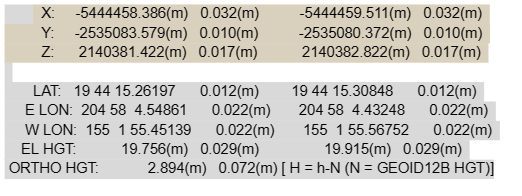
I wanted to double check that I am entering my manual base coordinates correctly. I obtained a “known point” using a survey grade GPS and got a report from OPUS. I attached a screenshot below with these coordinates used. Is it correct that in the “base mode” settings, I need to input them in WGS format and convert them to decimal degrees? For example, for my latitude it would be about 19.737572? Also, what do I enter in the “Height, m” box in the base settings? Is it the ellipsoidal height or orthometric height found in the OPUS report?
I eventually want to record my survey project in the “NAD83/Hawaii Zone 5 EPSG:26965” coordinate system. Does this make a difference for how I set up my base mode settings, etc?
Thank you in advance for anyone who may provide helpful advice! I am fairly new to using Emild RTK equipment so thanks for learning with me. Please let me know if there are any follow up questions.