how to use geoid model EGM2008 of 1 minute grid on Emlid flow,
in the app only gives the opcion to download the 2.5 minutes one, “us_nga_egm08_25.tiff”
I have geoid 1 minute file in tif and ggf format, but I dont see how to load it in the app.
At the moment, Emlid Flow doesn’t support uploading custom geoid models. I can note it as a feature request, but just wanted to ask: why do you need a 1 minute EGM2008 model? Is it for a specific project?
we are surveying also with other app, SurPad, we got a 1 minute geoid that is used in our country, Dominican Republic, and want both apps to use the same geoid resolution for more Precision in the orthometric elevation,
and also want to implement the 1 minute geoid in the photogrammetric procesing with MetaShape the geoid found in their website
The colleague says something very true and that is from the world of topography, perhaps it is difficult to imagine why I require a Geoid with a smaller grid than 2.5, but most brands of GPS support that resolution and also the processing programs.
When capturing heights with Emlid flow with the current geoid model, it produces elevation differences when confronted with points taken with Lyeca, Trimble, CHC etc.
The 1 minute models are common in topography and postpocesso, it is of daily use, here in Chile we use them a lot.
I support the colleague’s request, this is necessary for engineering surveying.
hi, I just noticed the Emlid Flow geoid 2008 was updated to 1’ resulution but it keeps on the name “25” for 2.5’ resolution,
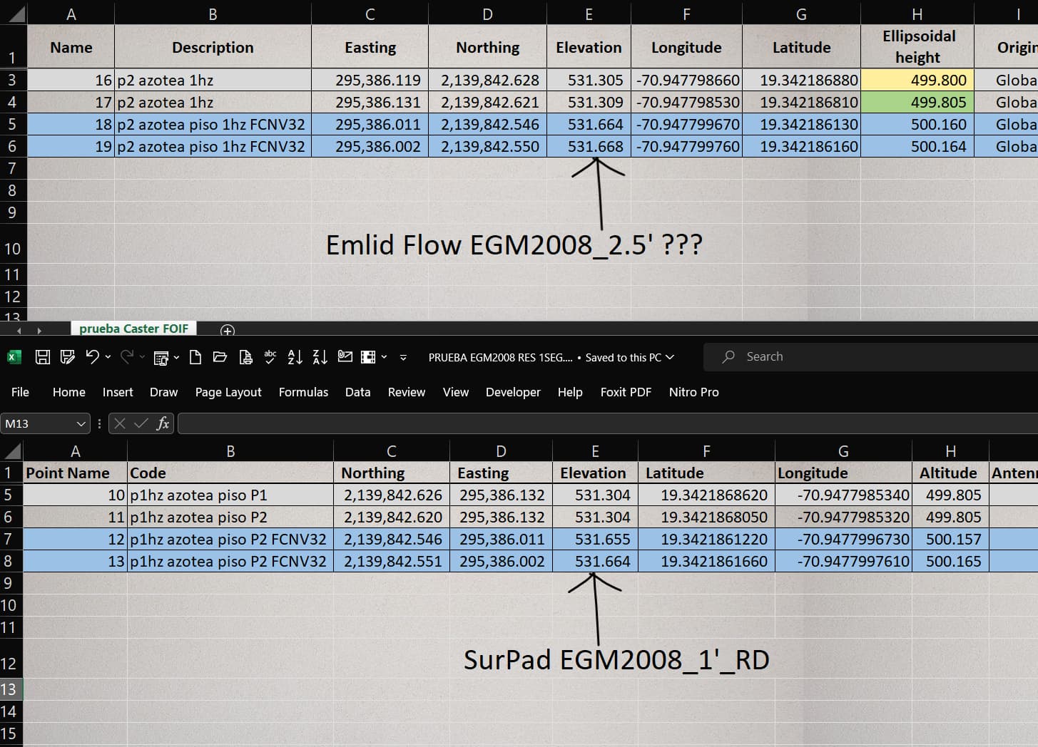
I made some tests, measuring points with emlid flow and surpad where I can switch geoid file, when applying the 1’ geoid file on surpad, elevations match the emlid ones,
and when I change to geoid 2.5’ the elevations differs by 28cm,
same point was measure several times with two cords,
it is nice the 1’ geoid file has been added, but the name should be updated,
and the 2.5’ option, I think, whould be kept in case for some project it needed.
see attached files…
Thank you for sharing your test results! This is interesting.
The model we have in the app still has a 2.5’ resolution. But it must be quite close to the 1’ model on flat surfaces. So that could be the reason for such results.
You can do the adjustments manually. I just found this raster that has the EGM2008 height above ellipsoid in a 1 minute (1/60th of a degree) grid Agisoft Metashape: Geoids