Hi, there doesn’t seem to be anyway to collect data from two points (A & B) then stake out a line between (A&B). I didn’t expect full COGO functions with the unit but I thought this would be a basic feature. Even if the the points had a Bearing you could maintain a heading OR a shadow line that is displayed between the points so you can see if you have moved of course. Not just a connection from the point to the rover position. Is this a future feature? it would be so useful.
I concur!
Yes this would be awesome
In the field it is basic to have this option implemented in stakeout.
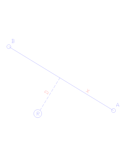
The chart illustrates what is required.
Given two known points A and B, let us show the distance D from the Rover to the line A-B perpendicularly and the distance X from point A.
Hi guys,
This feature is not there, currently, but we have plans to add it in future versions of ReachView 3. We had requests for this and other COGO features and understand the demand.
Thank you for sharing your thoughts too!
Very excited to know it is being considered!
Being able to measure two points, offset and plot a straight line would make cutting brush for fence lines a breeze!
It’s called “perpendicular offset” in the CONUS
That’s great news , looking forward to the feature.
Kind Regards
Brendan M Boyer
My pleasure, guys!
I would also like this feature. it would make the RV3 much more functional.
Hi Kevin,
Your request is also noted. Thanks!
This would be a game changer for some of us. Really looking forward to the implantation of this feature.
Totally understand this! We’ll do our best.
Hi Svetlana,
Any news on this function yet?
Regards
Buddy
Hi Buddy,
COGO is a big set of features, so it’s still at the research stage. We’ll post all the updates once we have something to share.
This topic was automatically closed 100 days after the last reply. New replies are no longer allowed.


