


hi, how long would you recommend logging for the base please? i followed your workflow here and my base point was over 1m away from the point i was expecting. I was logging for 30minutes - is that enough?
Hello,
My base was placed on an ordnance survey point so I had a known point to compare my reach results too.
In rtk post I set it as static.
Thank you!
if you logged data to create a base point then the resulting coordinates are in WGS84/ITRF/IGS08 what EXACTLY are you trying to compare this value to?
hi there,
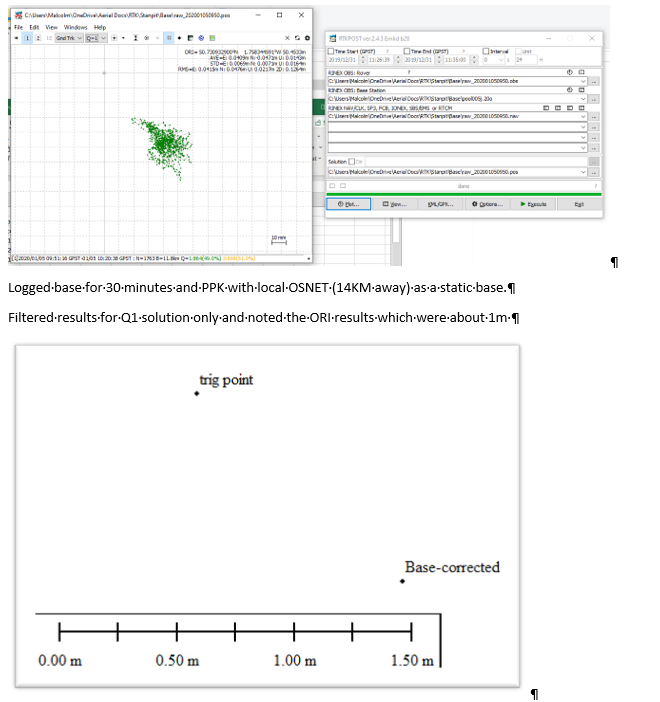
I was using a trig point in the UK.
i converted the eastings/northings to lat/long, so i expect i have missed something else.
I’m reading this from the OS website but its going a little over my head:
Triangulation stations
OSGB36 National Grid is now defined by the ETRS89 (European Terrestrial Reference System 1989) coordinates of the Ordnance Survey National GPS Network plus the definitive OSTN15 transformation. To obtain true OSGB36 National Grid coordinates for a point it must be first coordinated in ETRS89 from the National GPS Network. The transformation to OSGB36 via OSTN15 is then considered error free. See www.ordnancesurvey.co.uk/gps/ for more detail.
The coordinates supplied for this triangulation station have not been realised via ETRS89 and OSTN15. They are the original archive coordinates and can therefore no longer be considered as true OSGB36 National Grid Coordinates of the station. It is expected that agreement between ETRS89/OSTN15 derived coordinates and the original archive coordinates of triangulation stations (down to third order) will be at the 0.10 metre root mean square (r.m.s) level. Results returned will be limited to a maximum of 100 results.
I guess i should have somehow converted the OSGB36 National Grid Coordinates of the station to WGS84?
Would a few hours logging be enough time to get precision of say 200mm? and how much longer would you say for 20mm precision please?
Many thanks!
Hi,
i made sure to convert the OSGB36 easting/northings to WGS84 lat/long and my base is still over 1M away.
Do you think it was because i didnt log for long enough?
thanks
Hello,
My base was placed on an ordnance survey point so I had a known point to compare my reach results too.
In rtk post I set it as static.
Thank you!
Naaa, your point spread are within acceptable standard-deviation for the baseline, so I don’t think that is your problem. Several hours of logging usually only fluctuates up to 5-10 cm.
I also think the issue is caused by wrong/outdated base-coordinates, or some kind of error in converting.
1 Like
OK thank you Wizprod
I will have to go and try again!
Hi @malcolmdavidge,
Before post-processing the Reach’s RINEX log with a RINEX log from the base, what did you specify in RTKPost Options/Positions/Base position? Did you manually enter the base position in WGS84?
Hi @tatiana.andreeva
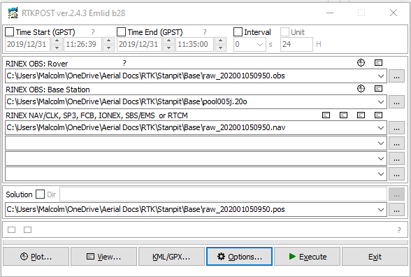
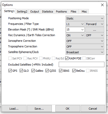
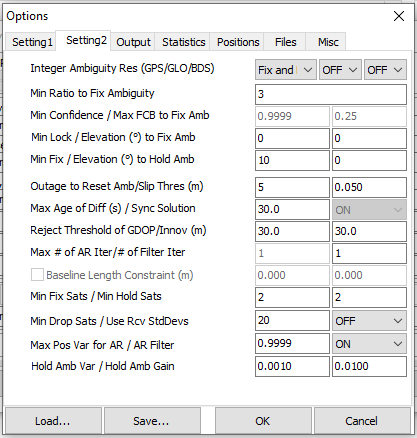
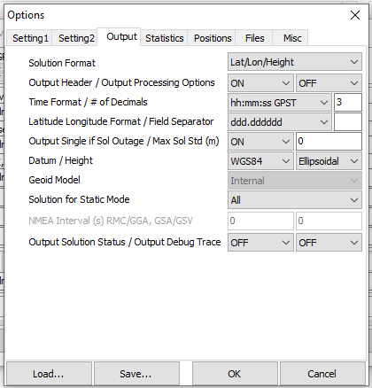
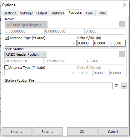
i didn’t manually enter the base position because i wanted to post process the reach independently to check my accuracy against a known point. these are the settings i used to process:
thank you 
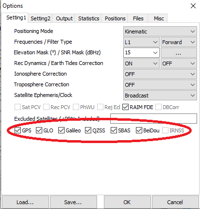
We didnt use BeiDou. would that matter?
Hi @tatiana.andreeva,
I have since tried another test placing GCP’s using propeller aeropoints:
unfortunately my results are really not very impressive so i hope you can help. I am starting to lose faith in the reach - i haven’t had a single positive result yet and i have been trying for over a year!
chichester.zip (5.3 MB)
i have uploaded the reach base logs and rinex data here, as well as the aeropoint results. The reach base was set up over the aeropoint #1 for a bout 3hours. when i processed it the reach was about 1m away from the aeropoint. please can you see if that is correct? many thanks
Are the Aeropoints and Reach unit corrected from the same source?
How have you verified that the Aeropoint’s position is correct?
1 meter off sounds much more like a conversion-error of some sort than anything else.
Also, there is a hole in the correction-data between 14-15?
1 Like
hi wizprod,
i believe the Aero’s utilise the same Rinex data. I cant think how to check the aero’s position other than that they are at least in the correct position visually, they claim accuracy of 20mm xy and 50mm z and they have far more experience than me 
i expect i am doing somethig wrong to get such bad results but i cant find it. I had the same issue when i tried to set the base over the survey point at the beginning of the year.
in the hard019k.20o file?
Believe or know? ![]()
How do you process the data from the aeropoints?
I am not familiar with how they work from a processing point of view.
i’m very sure they do use the same rinex data.
i THINK  one of the aero’s acts as a base, and the others create a network. they all communicate anyway, and the more you use the more accuracy you get. one on its own is not so great apparently. to process, you create a wifi hotspot and they all upload to the cloud, click process and choose your output. i was using ETRS89 EPSG code 4937
So cloud-magic happened
Do you have 2 units Reach units?
If you do, you could place the base unit on 1 aeropoint, and then use the rover for whatever you need to measure. Then, when post-processing, use the aero-point coordinate for the base position. Now you should be aligned.