We’re continuing our deep dive into GNSS basics. From a surveyor’s perspective, the space segment is essential as it directly impacts positioning accuracy and reliability. In today’s tip, we’ll explore how satellites operate.
Positioning data in
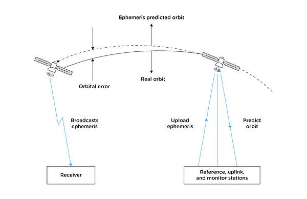
GNSS satellites don’t calculate their position on the fly—they’re placed into precisely planned orbits and continuously tracked by ground control, i.e. reference, uplink, and monitor stations on Earth. Their position is defined within a standardized coordinate system called WGS84. This shared reference frame allows satellites, control stations, and receivers to “speak the same language,” ensuring consistent and accurate global positioning. Let’s break this down a bit.
GNSS satellites rely on onboard systems to stay operational and accurate. Power is supplied by solar panels, while navigation data and system health are managed by internal computers. Precise orbit control is handled by small thrusters and reaction wheels. At the core of each satellite is an atomic clock—typically cesium or rubidium—which provides the ultra-precise timing needed for reliable positioning.
To ensure continued accuracy, the satellites are supported by ground control stations. which monitor satellite trajectories, correct for any orbital drift, and upload updated position data, known as ephemeris. Ephemeris data contains the predicted orbital positions of GNSS satellites over a short period of time—usually a few hours—satellite velocity, clock correction parameters, and health status of the satellite. This information allows a receiver to calculate where each satellite will be in the sky.
Positioning data out
Each GNSS satellite continuously broadcasts a radio signal containing the data needed for positioning. At the core of this signal is the carrier wave—the transport layer for delivering essential information to the receivers on Earth. The information sent includes two key elements:
-
Ranging code
A unique binary sequence that allows the receiver to determine how long the signal took to reach it. This time delay is used to estimate the distance to the satellite.
-
Navigation data
Contains the satellite’s orbital information, clock correction data, and status. This lets the receiver know exactly where the satellite was when it transmitted the signal.
Together, they form the foundation of GNSS positioning. Without accurate time and position data from the satellites, the receiver would not be able to compute its location reliably. In the next tip, we’ll take a closer look at GNSS signals and what happens after the receiver picks them up—specifically, how it processes that data to calculate the position.


